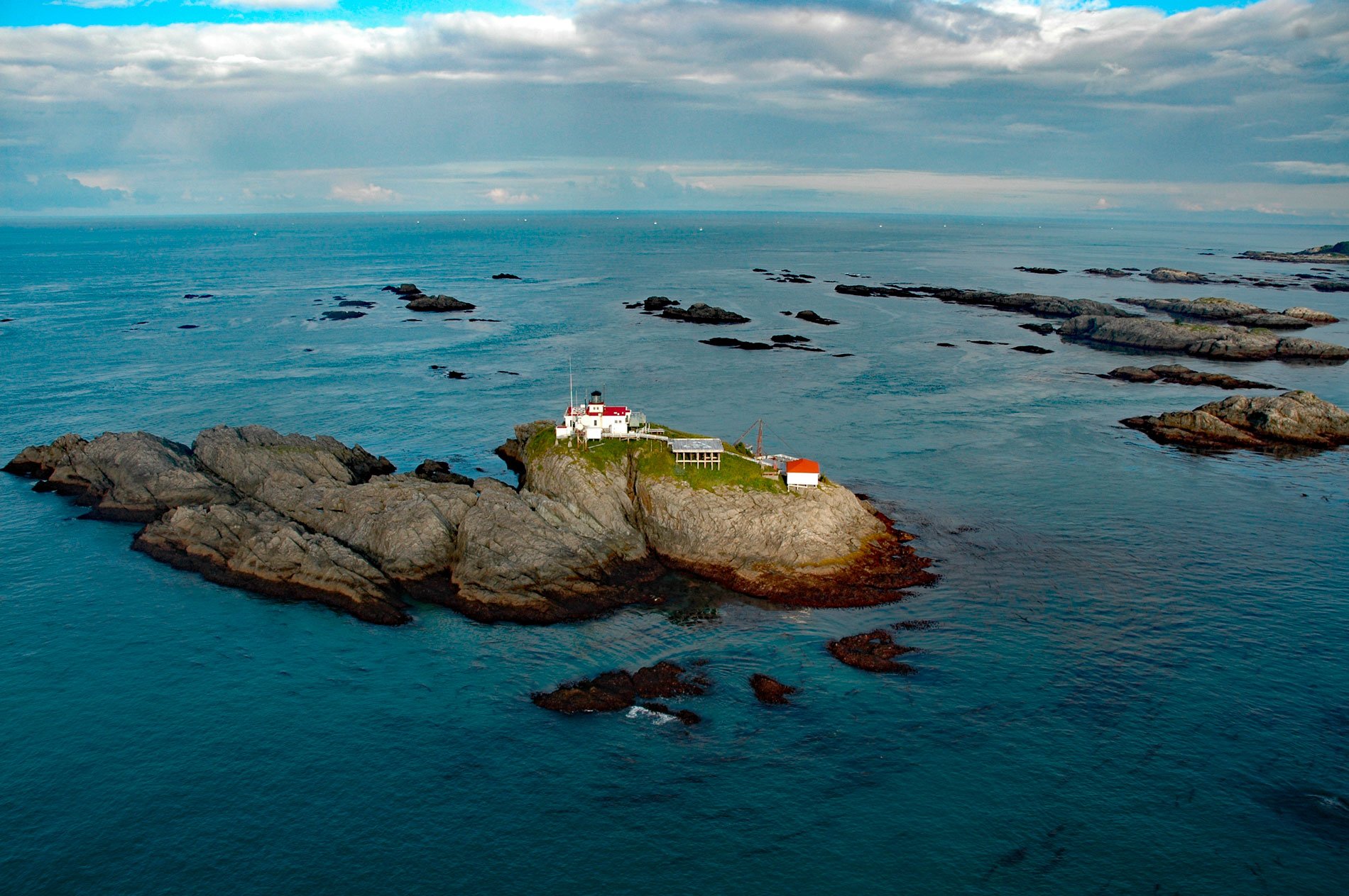
Cape Spencer is a prominent headland in Glacier Bay National Park and Preserve marking the northern entrance to Cross Sound adjacent to an area with numerous offshore islets, rocks, and islands, one of which, near the entrance to Dicks Arm, is the site of a historic lighthouse, about 45 miles (73 km) northwest of Hoonah and 37 miles (60 km) southwest of Gustavus, Alaska. Cross Sound was named by Captain James Cook in 1778 on Holy Cross day. Cape Spencer was named in 1794 by Captain George Vancouver for Earl George J. Spencer, who was a member of the English House of Commons and First Lord of the British Admiralty. The cape and most of the offshore islands are formed by metasedimentary rocks lithically similar to the Valdez Group, part of the Southern Margin Composite terrane that underlies much of the southern Alaska coast. The rocks principally consist of Sitka Greywacke, sandstone and mudstone turbidites that developed during the Cretaceous in a deep-water marine trench, slope-basin, and as submarine fan deposits.
Cross Sound is the traditional territory of the Tlingit Xunaa Kwáan, also known as the Hoonah Tlingit, where a kwáan is the fundamental unit of Tlingit social organization, consisting of all individuals living within the boundaries of the lands and waters controlled by the clans residing in a particular winter village. Hoonah Tlingit oral history is closely tied to Glacier Bay, archeological evidence and oral history place the Tlingit people and their predecessor’s occupation of the region at about 9,000 years. Hoonah oral accounts describe a village site that existed at Bartlett Cove prior to the most recent glacial advance during the Little Ice Age. One commonly told sacred narrative relates how the Hoonah people fled the readvancing ice sheet to their present-day village site at Hoonah on Chichagof Island. In 1794, Captain George Vancouver sailed south along the coast from Yakutat Bay and reached Cross Sound, where a party of Hoonah Tlingit paddled out from Cape Spencer in a canoe to trade with HMS Chatham. Small boats were dispatched from HMS Discovery to survey Cross Sound and Icy Strait, and the latter was described as being filled with ice. The vast quantity of ice near Glacier Bay’s entrance, coupled with the high velocity of the flowing tide, threatened to crush the party’s small boats, causing them to turn back.
In 1924, a light station was built on an unnamed island at the entrance to Cross Sound that consisted of a boathouse, blacksmith shop, aerial tramway, and a single-story reinforced concrete building for the fog signal equipment and to house the light keepers. The summit of the rock island is at 70 feet (21 m), and the light tower rises from the center of the structure’s roof another 25 feet (7.6 m). The island has sheer cliffs rising on all sides and no boat landing, so a landing platform, derrick, and hoisting machinery were built to facilitate the transfer of supplies and personnel. To get off the island the crane was hooked up to a boat 16 feet (5 m) long with an outboard engine, the men would climb into the boat and be swung by the crane over the edge of the island and dropped 60 feet (18 m) to the water. On one occasion, the boat was released from the cable, but the outboard could not be started, and the boat was swept out to sea in the strong currents. Returning to the island was no less hazardous, the boat had to be maneuvered under the hook at the base of the cliff, attached and lifted back up. Resupply was accomplished the same way, hoisting cargo nets of supplies up onto the boathouse deck. In 1974, due to rising maintenance costs, the light keepers were removed and the station automated. The small lighthouse is now accessed by helicopter and is still considered an important navigational aid and receives regular visits by the U.S. Coast Guard. Read more here and here. Explore more of Cape Spencer and Cross Sound here:

