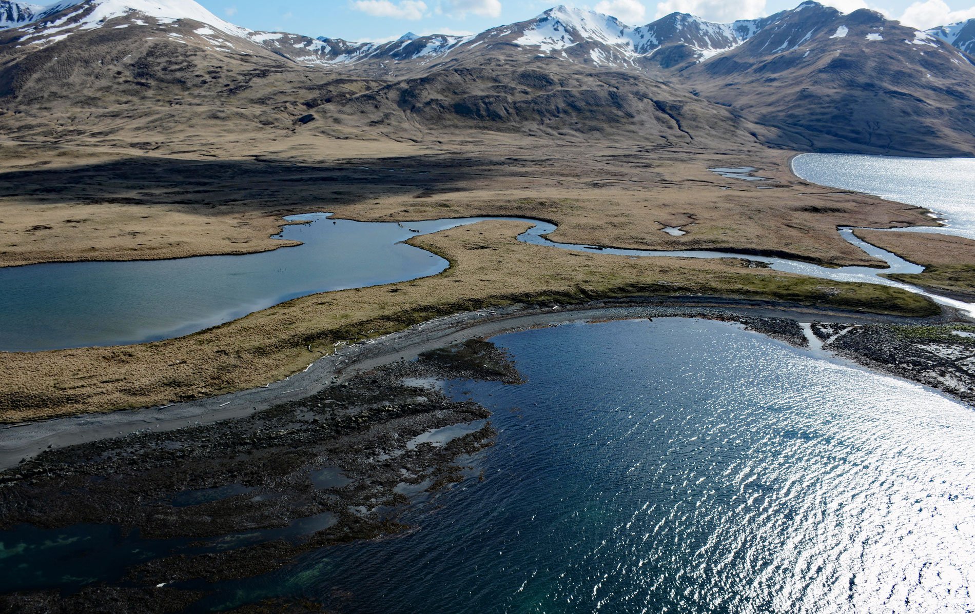
Kashega is an abandoned Aleut Unangan village on the Bering Sea coast of Unalaska Island, situated on a spit between Brennan Lake and Kashega Bay, about 79 miles (127 km) northeast of Nikolski and 39 miles (63 km) southwest of Dutch Harbor, Alaska. Kashega Bay was named in 1792 by Lieutenant Gavril Sarychev of the Imperial Russian Navy in honor of Yefim Koshigin a Russian promyslovik who spent the winter at Unalaska in 1763. The village is named after Kashega Bay and was first published on a chart by Sarychev as Koshiga Village. However, recent scholars suggest the name may have been derived from the Unanga word ‘Qusiix’. In the 18th century, there were seven villages on the Bering Sea coast of Unalaska Island including Chernofski and Makushin. Chernofski was inhabited for thousands of years but was abandoned in 1928 when most of the people moved to either Kashega or Unalaska. Kashega was located at the confluence of streams flowing from two freshwater lakes. The lakes support the most significant sockeye salmon runs in the Aleutian Islands. The larger and more western lake extends into a valley that leads past small streams and freshwater lagoons to Kuliliak Bay on the Pacific side of the island. This low pass between the precipitous Shaler Mountains to the north, that Veniaminov characterized as “high, steep, and impassable”, and the gently rolling hills to the south, provided a relatively easy portage for people and boats between the Gulf of Alaska and the Bering Sea. Alexander Baranov, the first manager of the Russian-American Company, described Kashega Bay as “one of the worst” bays on the island because of high winds that are funneled through the pass, but there was certainly a strategic advantage for the village to be located close to a reliable salmon run and a cross-island portage.
The Aleut Unangan developed a complex civilization consisting of multiple villages and settlements in one of the harshest places in North America. Archaeologists estimate the Unangan and their forbearers occupied the islands for at least 9,000 years. Based on estimates from Unangan oral history, the archaeological record, and early Russian period documents it is likely that about 12,000-15,0000 Unangan people occupied a territory that included the western end of the Alaska Peninsula, the Shumagin Islands just south of the peninsula, and the Aleutian archipelago from Unimak Island in the east to Attu Island in the west. The population was likely somewhat more concentrated in the eastern area of this territory due to the greater coastline available and a higher concentration of food resources. The earliest peoples used stone tools and constructed semi-subterranean longhouses called barabaras that were heated with oil lamps. They used whale bones and driftwood for roof beams and some had central floors up to 20 x 50 feet (6-15 m)with 2 to 14 adjoining rooms connected by low narrow passageways. The Unangan subsisted on halibut, cod, and shellfish, as well as the abundant sea mammals such as sea otters, Steller sea lions, harbor seals, and whales. In 1741, Russians were exploring the Aleutian Island and the Alaska mainland in search of sea otters for the maritime fur trade. The explorers were soon followed by Russian promyslovik, fur hunters who set out with increasing frequency into the rich waters of the Aleutian archipelago. These voyages often lasted several years, with crews returning to their homeland only when a sufficient supply of skins had been amassed. They exploited not only the fur resources but also the indigenous population. Because Unangan Aleut men were skilled at hunting, they were forced to hunt sea otters, first for independent Russian fur trading companies, and after 1799, for the Russian-American Company. In the 50 years following the first contact with Russian fur traders an estimated 80% of the Aleut Unangan population died. This loss occurred from the combined effects of Russian-Aleut conflicts, Russian atrocities, introduced diseases, and increased accidental deaths. As a result of this severe population loss, villages became fewer in number, and in some cases entire islands and island groups became deserted.
In 1831, Kashega was the headquarters of the foreman for the Russian-American Company on the west coast of Unalaska Island. In 1867, the Alaska Purchase transferred the Russian territory to the United States. The economy of the Aleutian Islands continued to be based on the exploitation of sea otter fur and salmon with Aleut Unangan providing much of the labor for these ventures. Kashega had a Russian Orthodox Holy Transfiguration Chapel near the bay, nine houses, a school with an outhouse and shed near the lake, and a cemetery at the opposite end of the bay from the church. A footbridge over the creek led to an Alaska Commercial Company store that was closed in 1897. In the summer of 1942, following the Imperial Japanese Navy attack on Dutch Harbor, 881 residents of the Aleutian Islands, almost all of them Aleut Unangan, were evacuated and transported to Southeast Alaska on the USS Delarof. The Kashega villagers were first moved to the grounds of a government-run Alaska Native boarding school in Wrangell, and then twenty residents from Kashega were sent to a camp at Ward Lake near Ketchikan. In April 1945, 18 former Kashega residents were returned to Unalaska. During the war, the military had destroyed or damaged many homes and several communities including Kashega were not formally resettled. Some families were split apart by economic or health concerns, such as hospitalization for tuberculosis, and some had died during their internment in Ketchikan. Only a few people decided to return to Kashega. Two Kashega men made a sustained attempt to resettle their former village, but they eventually left and moved to Unalaska. The village was finally abandoned in the 1950s. Only depressions from former houses and the remains of a few wooden structures are visible today. Read more here and here. Explore more of Kashega here:

