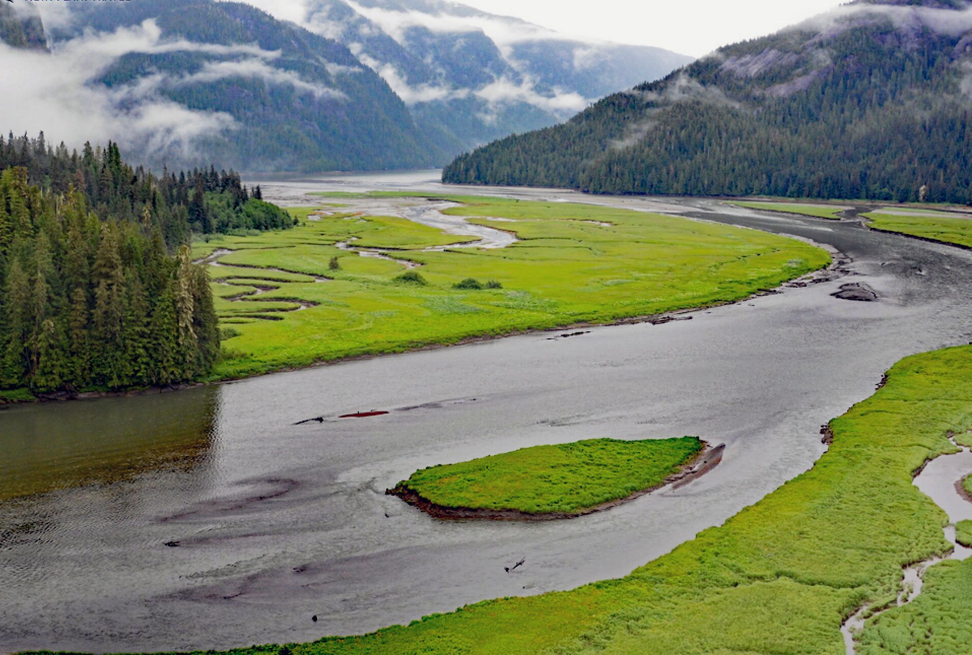
Gilttoyees Creek starts from a series of cirque basins on the east and south flank of Tentacle Peak in the Kitimat Ranges and flows generally southeast for about 20 miles (32 km) through the Foch-Gilttoyees Provincial Park and Protected Area to Gilttoyees Inlet which opens to Douglas Channel, about 60 miles (97 km) southeast of Prince Rupert and 20 miles (32 km) southwest of Kitimat, British Columbia. The creek is named after the inlet and is derived from the Haisla ‘Giltu’yis’ meaning ‘long inlet’. The inlet was first charted but not named by Captain George Vancouver in 1793, who also named Douglas Channel in honor of Sir James Douglas, the first governor of the Colony of British Columbia. Gilttoyees Creek drains an alpine watershed of 69,246 acres (28,023 ha) and deposits the accumulated suspended sediments in an estuary notable for its intertidal flats dominated by salt marsh communities. The estuary has very high wildlife values, particularly as an over-wintering habitat for trumpeter swan, Barrow’s goldeneye, harlequin duck, surf scoter, long-tailed duck, and western grebe. Gilttoyees Inlet extends 9 miles (15 km) generally south from the mouth of Gilttoyees Creek to Douglas Channel. Foch-Gilttoyees Park and Protected Area is in the Coast Mountain Range on the north side of the Douglas Channel and encompasses 151,186 acres (61,183 ha) of rugged coastal and mountainous terrain including snow-covered peaks, glacial tarns, cirque basins, and receding glaciers. The park includes diverse habitats such as pristine alpine watersheds, old-growth forests, tidal estuaries, and an isolated undeveloped coastline. The park adjoins the Gitnadoiks River Provincial Park to the north, providing a contiguous protected corridor between the Douglas Channel and the Skeena River. The corridor was historically used by First Nations as a trade route between the Skeena River and the Douglas Channel and was reputedly called a ‘grease trail‘, the grease being valuable fish oil derived from eulachons, an anadromous fish once plentiful in Gilttoyees Creek and Douglas Channel.
In 1788, British Captain Charles Duncan on Princess Royal engaged in the maritime fur trade may have been the first European to enter Douglas Channel but did not venture far before turning and making for Haida Gwaii. In 1792, Spanish Captain Don Jacinto Caamano on the Aranzazu anchored near the southern end of Hawkesbury Island and then sent Second Pilot Martinez y Zayas up Douglas Channel in a longboat. Martinez y Zayas traveled about 54 miles (87 km) and saw only one indigenous fishing canoe. In June of 1793, Captain George Vancouver anchored HMS Discovery and sent a cutter and a launch under the command of Lieutenant Joseph Whidbey and Robert Barrie deep into the fjords of the mainland. Whidbey’s party included the surgeon and naturalist Archibald Menzies and they explored Douglas Channel and noted the entrance to Gilttoyees Inlet. They also made contact and were treated well by the Indigenous X’aisla of the Kitamaat people. The Kitamaat are a combination of at least three pre-European contact bands including the Nalabila, meaning dwellers upriver (on the Kitimat River), the X’aisla, meaning dwellers farthest downriver (on the Kitimat River), and the Gildalidox, who were inhabitants of Kildala Arm. Sometime before the first white settlement, the three branches began to winter together at the village of the X’aisla, located just upstream from the mouth of the Kitimat River at the head of Douglas Channel. In 1893, the Methodist missionary George Raley established Kitamaat Mission on an old village site on the east shore of Douglas Channel about 5 miles (8 km) from the X’aisla village. Christian converts moved there and by the early 20th century virtually all the Kitamaat (now Haisla) had undergone at least nominal conversion and migrated to Kitamaat Mission. The natives returned to the old X’aisla village site to potlatch out of reach of the missionary and Indian agent. The Kitimat River historically was a major salmon stream and supported an important eulachon run, and the old village site was still used to catch and process fish.
The anadromous eulachon is a small species of smelt that spawns in the lower reaches of coastal rivers and streams from northern California to the southern Bering Sea. The eulachon was one of the most valuable resources for the Kitamaat. The fish was central to sustenance, culture, economy, and relations with neighboring tribes. Until 1998, eulachons arrived in the rivers of Douglas Channel every March. They were the first anadromous fish to arrive after a long winter and their return signaled the beginning of spring and was celebrated by indigenous communities. The fish were cooked or smoked for eating or were rendered into oil to be used as medicine and were important for their social, cultural, and economic value. Eulachon oil was a central trade commodity and highly valued by interior First Nations. Ancient indigenous trade routes connected coastal and interior trading partners prior to contact with Europeans. The X’aisla traveled the Gilttoyees-Gitnadoiks trail and traded eulachon oil for smoked moose meat, soapberries, and buckskin moccasins, gloves, and coats with tribes from the upper Skeena watershed. The X’aisla also traded eulachon oil with their western neighbors for abalone, seaweed, red cod, black cod, halibut, clams, and herring eggs. Nearly all eulachon spawning runs have declined from California to southeastern Alaska especially since the mid-1990s. The causes of the declines are uncertain, but over-harvesting and climate change are implicated as a cause of a general decline, but other factors cannot be overlooked, including local habitat alterations and bycatch in commercial trawl fisheries. The decline of eulachons is a concern for many fisheries managers and the commercial fishing industry because eulachons are common as bycatch in shrimp trawls in some areas. The decline of eulachons has prompted specific management actions to limit eulachon bycatch, and such actions may reduce potential shrimp catches in some areas. Read more here and here. Explore more of Gilttoyees Inlet here:

