Beaches
Recent Articles
More Articles
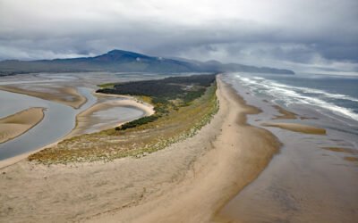
Netarts Spit, Cape Lookout State Park
Netarts Spit is in Cape Lookout State Park and extends north for 6 miles (10 km) from Cape Lookout, forming Netarts Bay, an estuary of 2,179 acres (883 ha) for several minor streams draining the western flank of an unnamed peninsula separating Tillamook Bay from the Pacific Ocean, about 53 miles (85 km) south of Astoria and 5.7 miles (9 km) west-southwest of Tillamook, Oregon.
Hoh River, Olympic National Park
Hoh River starts from the terminus of the Hoh Glacier at an elevation of roughly 4,200 feet (1,280 m) on the northeast flank of Mount Olympus in Olympic National Park and flows generally west-southwest for 56 miles (90 km) draining a watershed of 191,360 acres (77,441 ha) to the Pacific Ocean, about 99 miles (159 km) west of Seattle and 15 miles (24 km) south of Forks, Washington.
Leffingwell Camp, Flaxman Island
Leffingwell Camp is situated on Flaxman Island, a shape-shifting barrier island separating the Beaufort Sea to the north and Lion Bay to the south, about 58 miles (94 km) east of Deadhorse and 58 miles (94 km) west of Kaktovik, Alaska.
Makarius Bay, Amchitka Island
Makarius Bay is on the southeastern coast of Amchitka Island, the southernmost of the Rat Islands group in the Aleutian Islands of Southwest Alaska, bounded by the Bering Sea to the north and the Pacific Ocean to the south, about 2500 miles (4024 km) north-northwest of Honolulu and 182 miles (293 km) west-southwest of Adak, Alaska.
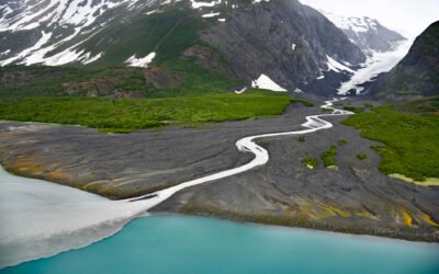
Dinglestadt Glacier, Kenai Fjords National Park
Dinglestadt Glacier has two land terminating lobes that straddle a watershed divide in the Kenai Mountains, with a minor lobe descending southeast for 4 miles (6 km) from an elevation of roughly 3300 feet (1006 m) to a tidal delta on the western shore of McCarty Glacier in Kenai Fjords National Park, about 44 miles (71 km) south-southwest of Seward and 42 miles (68 km) east of Homer, Alaska.
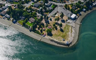
Cordova Bay, Saanich Peninsula
Cordova Bay is a shallow bight and a community located on the eastern shore of the Saanich Peninsula in the municipality of Saanich, one of the 13 cities comprising the Greater Victoria Region on Vancouver Island, about 9 miles (14.5 km) south-southeast of Sidney and 7 miles (11 km) north of downtown Victoria, British Columbia.
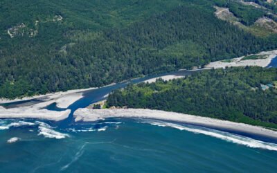
Floras Creek, New River
Floras Creek starts from an elevation of roughly 2,786 feet (849 m) on the north flank of Edson Butte in the Oregon Coast Range and flows generally west for 13 miles (21 km), draining a watershed of 51,652 acres (20,903 ha) to the outlet of Floras Lake where the stream makes a sharp turn to the north and becomes the New River, about 12 miles (19 km) north of Port Orford and 3 miles (5 km) west-southwest of Langlois, Oregon.
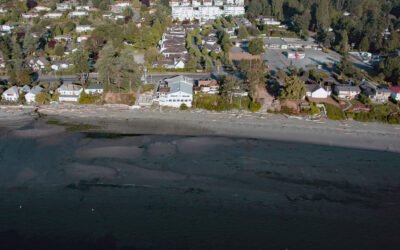
Browns Point, East Passage
Browns Point is a conspicuous landmark in Puget Sound located at the southern end of East Passage and at the entrance to Commencement Bay, about 21 miles (34 km) south-southwest of Seattle and 4 miles (6.5 km) north of Tacoma, Washington.
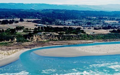
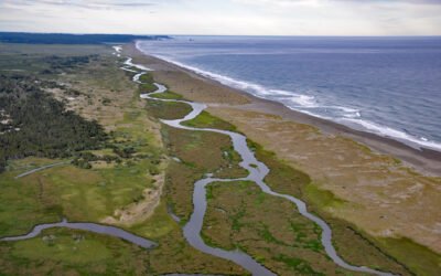
Mad River, McKinleyville
Mad River starts in the Coast Range at an elevation of 4,845 ft (1,477 m) and flows generally northwest for 113 miles (182 km), draining a watershed of 318,080 acres (128,722 ha), and enters the Pacific Ocean about 12 miles (19 km) north of Eureka and 1.8 miles (3 km) northwest of McKinleyville, California.
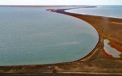
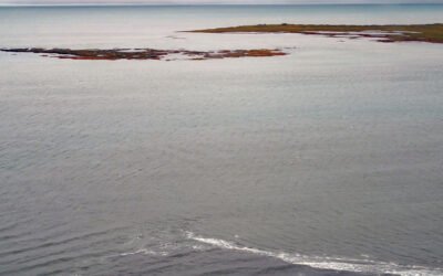
Point Barrow, Elson Lagoon
Point Barrow is a spit that extends northeast from the mainland for 4 miles (6.4 km) into the Arctic Ocean forming Elson Lagoon to the southeast, about 150 miles (242 km) northwest of Nuiqsut and 9.8 miles (16 km) northeast of Utqiaġvik, Alaska.
About the background graphic
This ‘warming stripe’ graphic is a visual representation of the change in global temperature from 1850 (top) to 2019 (bottom). Each stripe represents the average global temperature for one year. The average temperature from 1971-2000 is set as the boundary between blue and red. The colour scale goes from -0.7°C to +0.7°C. The data are from the UK Met Office HadCRUT4.6 dataset.
Click here for more information about the #warmingstripes.