Glaciers
Recent Articles
More Articles
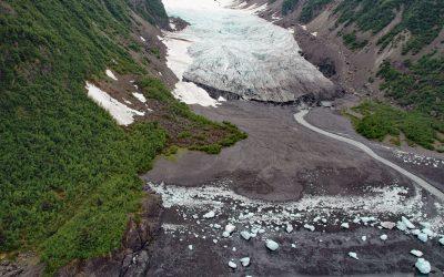
Tigertail Glacier, Nassau Fjord
Tigertail Glacier starts at an elevation of about 2,850 feet (869 m) in the Sargent Icefield on the Kenai Peninsula and flows generally northeast for 3.3 miles (5.3 km) and terminates 0.2 miles (0.3 km) from the western shore of Nassau Fjord, which is a northern arm of Icy Bay in western Prince William Sound, about 36 miles (58 km) east-northeast of Seward and 36 miles (58 km) south-southeast of Whittier, Alaska.
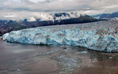
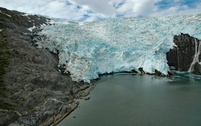
Hubbard Glacier, Disenchantment Bay
Hubbard Glacier originates from icefields at an elevation of around 11,000 feet (3,400 m) in the Centennial Range of the Saint Elias Mountains in Kluane National Park and Reserve and flows about 48 miles (77 km) to the Alaska border and then continues for another 28 miles (45 km) through Wrangell-Saint Elias National Park to its terminus in Disenchantment Bay, about 220 miles (355 km) east-southeast of Cordova and 32 miles (52 km) north-northeast of Yakutat, Alaska.
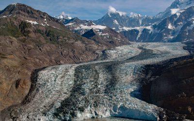
Tyndall Glacier, Taan Fjord
Tyndall Glacier starts at an elevation of about 10,000 feet (3,050 m) in the Saint Elias Mountains near the Canadian border, between Mount Huxley to the west and Mount Saint Elias to the east, and flows generally south-southwest for 13 miles (21 km) to the head of Taan Fjord in Icy Bay, about 160 miles (258 km) east-southeast of Cordova and 68 miles (110 km) northwest of Yakutat, Alaska.
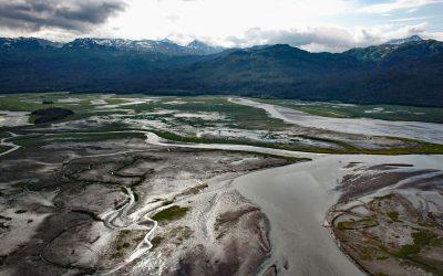
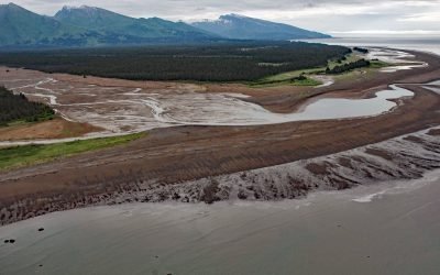
Bradley River, Kachemak Bay
Bradley River is located on the Kenai Peninsula and flows generally northwest for 7 miles (11 km) from Bradley Lake at an elevation of 1,090 feet (332 m) to Kachemak Bay, about 31 miles (50 km) southeast of Ninilchik and 25 miles (40 km) northeast of Homer, Alaska.
Red River, Lake Clark National Park and Preserve
Red River starts from the terminus of Red Glacier on the eastern flank of Mount Iliamna and flows southeast for 7 miles (11.3 km) through Lake Clark National Park and Preserve to the western shore of Cook Inlet, about 126 miles (203 km) southwest of Anchorage and 48 miles (77 km) northwest of Homer, Alaska.
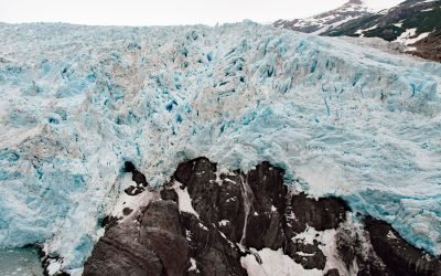
Harriman Glacier, Prince William Sound
Harriman Glacier is 8 miles (13 km) long, and trends northeast to its terminus at the head of Harriman Fjord, in Prince William Sound, about 74 miles (119 km) west-southwest of Valdez and 16 miles (26 km) northeast of Whittier, Alaska.
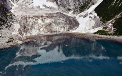
Anchor Glacier, Northwestern Fjord
Anchor Glacier starts from an elevation of about 5700 feet (1737 m) on the eastern flank of McCarty Ridge in the Kenai Mountains and cascades east for 3 miles (5 km) to Northwestern Fjord, about 52 miles (84 km) east-northeast of Homer and 32 miles (52 km) southwest of Seward, Alaska.
Tiger Glacier, Icy Bay
Tiger Glacier starts at an elevation of 5,400 feet (1,646 m) in the Sargent Icefield on the Kenai Peninsula and flows east for 8 miles (13 km), covering an area of 15,040 acres (6,090 ha), to a tidewater terminus about 0.5 miles (0.8 km) wide at the head of Icy Bay in Prince William Sound, about 98 miles (158 km) southwest of Valdez and 42 miles (68 km) east-southeast of Whittier, Alaska.
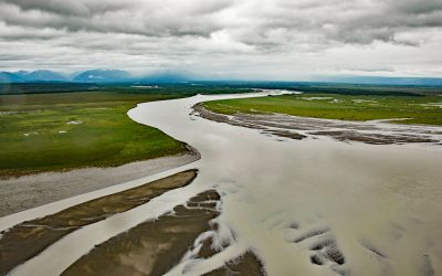
McArthur River, Trading Bay
McArthur River starts at the terminus of McArthur Glacier in the Neacola Mountains and flows southeast for about 9 miles (15 km) to the confluence of the outflow from the Blockade Glacier in the Chigmit Mountains, and then continues for another 21 miles (34 km) through the Trading Bay State Game Refuge to the western coast of Cook Inlet, about 65 miles (105 km) southwest of Anchorage and 29 miles (46 km) northwest of Kenai, Alaska.
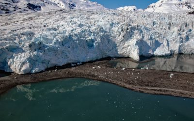
Blackstone Glacier, Blackstone Bay
Blackstone Glacier starts at an elevation of about 5,000 feet (1,500 m) in the Kenai Mountains and flows generally north for 7 miles (11 km) and terminates at tidewater at the head of Blackstone Bay, about 87 miles (140 km) west-southwest of Valdez and 8 miles (13 km) south of Whittier, Alaska.
About the background graphic
This ‘warming stripe’ graphic is a visual representation of the change in global temperature from 1850 (top) to 2019 (bottom). Each stripe represents the average global temperature for one year. The average temperature from 1971-2000 is set as the boundary between blue and red. The colour scale goes from -0.7°C to +0.7°C. The data are from the UK Met Office HadCRUT4.6 dataset.
Click here for more information about the #warmingstripes.