Islands
Recent Articles
More Articles
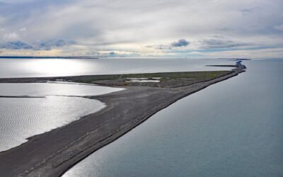
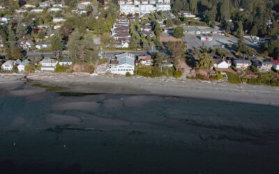
Bodfish Island, Simpson Lagoon
Bodfish Island is part of the Jones Island barrier chain between Cottle Island to the east and Bertoncini Island to the west, separating Simpson Lagoon from the Beaufort Sea, about 178 miles (286 km) southeast of Utqiagvik and 30 miles (48 km) northwest of Deadhorse, Alaska.
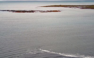
Leffingwell Camp, Flaxman Island
Leffingwell Camp is situated on Flaxman Island, a shape-shifting barrier island separating the Beaufort Sea to the north and Lion Bay to the south, about 58 miles (94 km) east of Deadhorse and 58 miles (94 km) west of Kaktovik, Alaska.
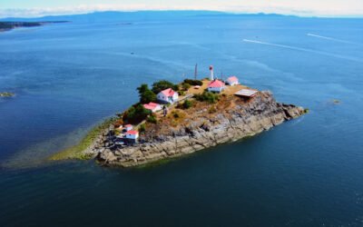
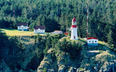
Chrome Island, Baynes Sound
Chrome Island is located 0.15 miles (0.24 km) south of Boyle Point Provincial Park, on the southern tip of Denman Island, and is the site of a historic lighthouse that marks the southern entrance to Baynes Sound, about 72 miles (116 km) west-northwest of Vancouver and 2 miles (3.2 km) east-northeast of Deep Bay, British Columbia.
Makarius Bay, Amchitka Island
Makarius Bay is on the southeastern coast of Amchitka Island, the southernmost of the Rat Islands group in the Aleutian Islands of Southwest Alaska, bounded by the Bering Sea to the north and the Pacific Ocean to the south, about 2500 miles (4024 km) north-northwest of Honolulu and 182 miles (293 km) west-southwest of Adak, Alaska.
Cordova Bay, Saanich Peninsula
Cordova Bay is a shallow bight and a community located on the eastern shore of the Saanich Peninsula in the municipality of Saanich, one of the 13 cities comprising the Greater Victoria Region on Vancouver Island, about 9 miles (14.5 km) south-southeast of Sidney and 7 miles (11 km) north of downtown Victoria, British Columbia.
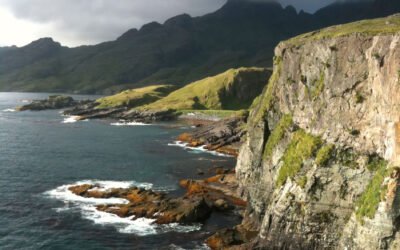
Langara Island, Haida Gwaii
Langara is the northernmost island of the Haida Gwaii archipelago and the site of a historic light station that marks the southern boundary of Dixon Entrance, about 94 miles (151 km) southwest of Ketchikan, Alaska and 38 miles (61 km) west-northwest of Masset, British Columbia.
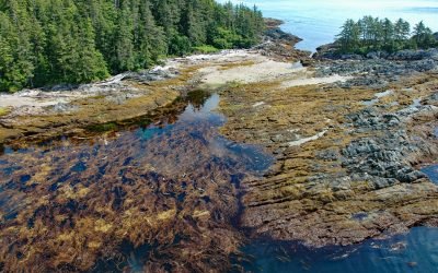
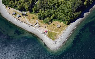
Boot Bay, Adak Island
Boot Bay is 3 miles (5 km) west of Kagalaska Strait on the south coast of Adak Island, the site of intensive military activity from 1942 to 1997, near the western extent of the Andreanof Islands group of the Aleutian Islands, about 443 miles (713 km) southwest of Unalaska and 11 miles (18 km) southeast of the community of Adak, Alaska.
Kaigani Point, Long Island
Kaigani Point is at the southwest tip of Long Island between Kaigani Strait to the west and Cordova Bay to the east, about 100 miles (161 km) northwest of Prince Rupert and 56 miles (90 km) southwest of Ketchikan, Alaska.
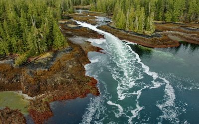
Skookumchuck, Brownson Island
A skookumchuck is a tidal rapid that occurs at the mouth of an unnamed embayment that nearly bisects Brownson Island which is located on the west shore of Ernest Sound and separated from Etolin Island by Canoe Passage, about 47 miles (75 km) north-northwest of Ketchikan and 36 miles (58 km) south of Wrangell, Alaska.
Point Robinson, Maury Island
Point Robinson is the eastern point of Maury Island in Puget Sound and the site of a historic lighthouse, about 15 miles (24 km) south of Seattle and 10 miles (16 km) north-northeast of Tacoma, Washington.
About the background graphic
This ‘warming stripe’ graphic is a visual representation of the change in global temperature from 1850 (top) to 2019 (bottom). Each stripe represents the average global temperature for one year. The average temperature from 1971-2000 is set as the boundary between blue and red. The colour scale goes from -0.7°C to +0.7°C. The data are from the UK Met Office HadCRUT4.6 dataset.
Click here for more information about the #warmingstripes.