LAST MONTH
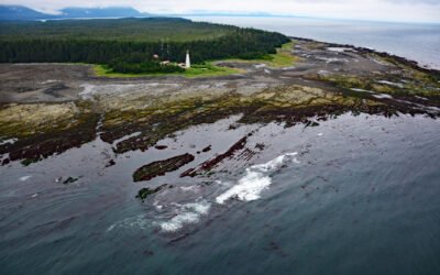
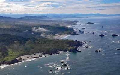
Estevan Point, Hesquiat Peninsula
Estevan Point is the site of a historic lighthouse at the end of the Hesquiat Peninsula which forms the southern entrance to Nootka Sound on the west coast of Vancouver Island, about 35 miles (56 km) southwest of Gold River and 33 miles (53 km) northwest of Tofino, British Columbia.
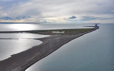
Bodfish Island, Simpson Lagoon
Bodfish Island is part of the Jones Island barrier chain between Cottle Island to the east and Bertoncini Island to the west, separating Simpson Lagoon from the Beaufort Sea, about 178 miles (286 km) southeast of Utqiagvik and 30 miles (48 km) northwest of Deadhorse, Alaska.
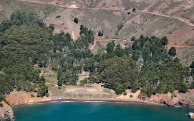
Kirby Cove, Marin Headlands
Kirby Cove is an embayment in the Marin Headlands on the northern shore of the Golden Gate in the Golden Gate National Recreation Area, and the site of a historic military installation, about 5.5 miles (9 km) northwest of downtown San Francisco and 2.3 miles (4 km) south of Sausalito, California.
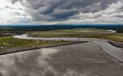
Kasilof River, Kenai Peninsula
Kasilof River starts at the outlet of Tustumena Lake on the Kenai Peninsula and flows generally northwest for 17 miles (27 km) through the Kenai Lowland to Cook Inlet, draining a watershed of 93,275 acres (37,747 ha), about 51 miles (82 km) north-northeast of Homer and 13 miles (21 km) south-southwest of Kenai, Alaska.
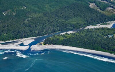
Lone Ranch Beach, Cape Ferrelo
Lone Ranch Beach is a sand and gravel deposit at Cape Ferrelo situated between Lone Ranch Creek to the north and Ram Creek to the south in Samuel H. Boardman State Scenic Corridor, about 22 miles (35 km) south of Gold Beach and 5 miles (8 km) northwest of Brookings, Oregon.
Tongue Point, Crescent Bay
Tongue Point is a rocky ledge in the Strait of Juan de Fuca that projects from a peninsula forming the eastern shore of Crescent Bay on the north coast of the Olympic Peninsula and the site of a historical port and shipwreck, about 44 miles (71 km) east-southeast of Neah Bay and 13 miles (21 km) west-northwest of Port Angeles, Washington.
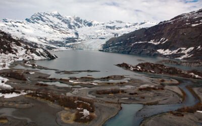
Gilman Glacier, Johns Hopkins Inlet
Gilman Glacier starts at an elevation of roughly 6,000 feet (1,828 m)in the Fairweather Range of the Saint Elias Mountains and flows generally northwest for 7.5 miles (12 km) to Johns Hopkins Inlet in Glacier Bay National Park and Preserve, about 105 miles (169 km) southeast of Yakutat and 58 miles (93 km) northwest of Gustavus, Alaska.
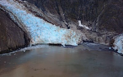
Shoup Glacier, Port Valdez
Shoup Glacier starts at an elevation of roughly 6,800 feet (2,073 m) in the Chugach Mountains between Mount Shouplina to the west and Mount Logan to the east, and flows 16 miles (26 km) generally south-southwest to Shoup Bay on the northwest shore of Port Valdez in Prince William Sound, about 74 miles (119 km) east-northeast of Whittier and 9 miles (15 km) west of Valdez, Alaska.
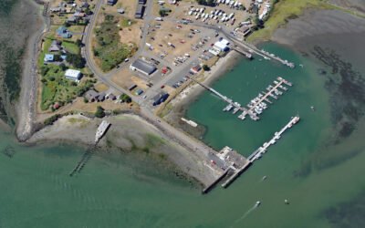
Toke Point, Willapa Bay
Toke Point is at the end of Tokeland Spit that projects southeast for 3 miles (5 km) from the northern shore of Willapa Bay, a large estuary formed by several streams, the largest being Willapa River, about 55 miles (89 km) southwest of Olympia and 15 miles (24 km) south-southeast of Westport, Washington.
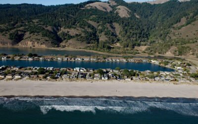
Stinson Beach, Bolinas Bay
Stinson Beach is a community on Bolinas Bay developed on a crescent-shaped sand spit partially enclosing Bolinas Lagoon between Duxbury Point to the northwest and Rocky Point to the south, about 15 miles (24 km) northwest of San Francisco and 14 miles (23 km) south-southeast of Point Reyes Station, California.
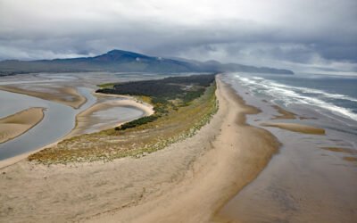
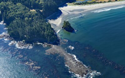
Netarts Spit, Cape Lookout State Park
Netarts Spit is in Cape Lookout State Park and extends north for 6 miles (10 km) from Cape Lookout, forming Netarts Bay, an estuary of 2,179 acres (883 ha) for several minor streams draining the western flank of an unnamed peninsula separating Tillamook Bay from the Pacific Ocean, about 53 miles (85 km) south of Astoria and 5.7 miles (9 km) west-southwest of Tillamook, Oregon.
Hoh River, Olympic National Park
Hoh River starts from the terminus of the Hoh Glacier at an elevation of roughly 4,200 feet (1,280 m) on the northeast flank of Mount Olympus in Olympic National Park and flows generally west-southwest for 56 miles (90 km) draining a watershed of 191,360 acres (77,441 ha) to the Pacific Ocean, about 99 miles (159 km) west of Seattle and 15 miles (24 km) south of Forks, Washington.