Lighthouses
Recent Articles
More Articles
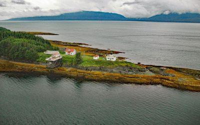
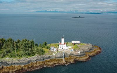
Point Retreat, Admiralty Island
Point Retreat is a headland with a historic lighthouse on the Mansfield Peninsula at the northern tip of Admiralty Island, between Lynn Canal to the west and Saginaw Channel of Stephens Passage to the east, about 60 miles (97 km) south-southeast of Haines and 20 miles (32 km) northwest of Juneau, Alaska.
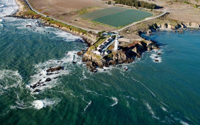
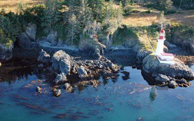
Pigeon Point Lighthouse, Pigeon Point
Pigeon Point is a prominent headland and the site of a historic lighthouse, situated between Bolsa Point to the north and Franklin Point to the south, about 25 miles (40 km) northwest of Santa Cruz and 5 miles (8 km) south of Pescadero, California.
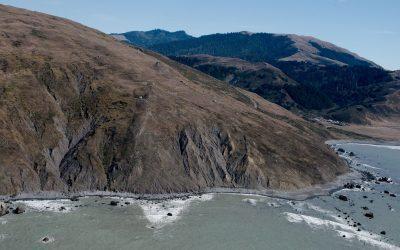
Cape Mendocino, Lost Coast
Cape Mendocino is a major headland on the Lost Coast and the westernmost point in California, situated between Bear River to the north and Mattole River to south, about 210 miles (338 km) northwest of San Francisco, and 28 miles (45 km) southwest of Eureka, California.
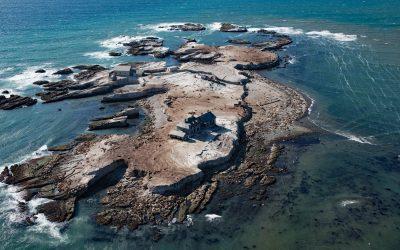
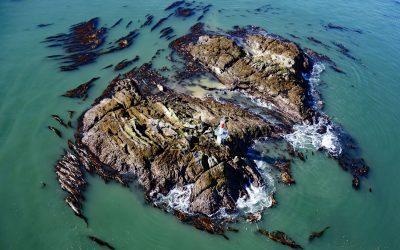
Año Nuevo Island, Año Nuevo State Park
Año Nuevo Island is the site of a historic light tower and fog signal on about 9 acres (3.6 ha) and separated from Point Año Nuevo by a shallow channel encompassed by Año Nuevo State Park, about 21 miles (34 km) northwest of Santa Cruz and 11 miles (18 km) south-southeast of Pescadero, California.
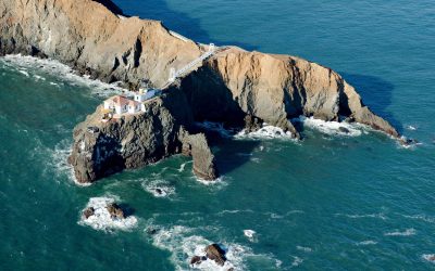
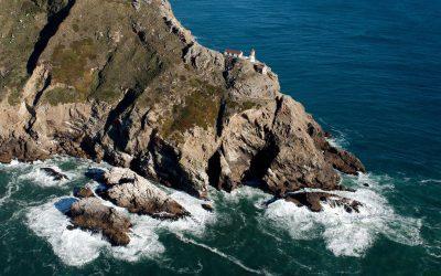
Point Bonita, Marin Headlands
Point Bonita is the site of a historic lighthouse situated on the Marin Headlands at the northern entrance to the Golden Gate, about 7 miles (11 km) west-northwest of San Francisco, and 4 miles (7 km) southwest of Sausalito, California.
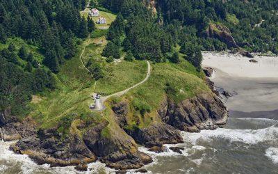
North Head, Ilwaco
North Head is a rocky promontory with a summit elevation of 300 feet (91 m) and the site of a historic lighthouse situated on Cape Disappointment at the mouth of the Columbia River between Baker Bay to the east and the Pacific Ocean to the west, about 14 miles (23 km) northwest of Astoria and 2 miles (3.2 km) southwest of Ilwaco, Washington.
Point Reyes, Point Reyes National Seashore
Point Reyes is a prominent headland with a historic lighthouse located in Point Reyes National Seashore, a park and nature preserve of 71,028 acres (28,744 ha), about 35 miles (56 km) northwest of San Francisco and 12 miles (19 km) southwest of Inverness, California.
Five Fingers, Stephens Passage
Five Fingers is a group of islets and the site of a historic lighthouse situated at the southern entrance to Stephens Passage, about 67 miles (108 km) east-northeast of Sitka and 41 miles (66 km) northwest of Petersburg, Alaska.
Sheringham Point, Strait of Juan de Fuca
Sheringham Point is the site of a historic lighthouse located on the southern shore of Vancouver Island and on the Strait of Juan de Fuca, between Otter Point to the east and Point No Point to the west, about 26 miles (42 km) west-southwest of Victoria and 7 miles (11 km) southeast of Jordon River, British Columbia.
Lawyer Island, Malacca Passage
Lawyer Islands are located in Malacca Passage, part of the Canadian Inside Passage between Porcher Island to the south and the Tsimpsean Peninsula to the north and just off the mouth of the Skeena River, about 102 miles (165 km) southeast of Ketchikan and 13 miles (20 km) south of Prince Rupert, British Columbia.
About the background graphic
This ‘warming stripe’ graphic is a visual representation of the change in global temperature from 1850 (top) to 2019 (bottom). Each stripe represents the average global temperature for one year. The average temperature from 1971-2000 is set as the boundary between blue and red. The colour scale goes from -0.7°C to +0.7°C. The data are from the UK Met Office HadCRUT4.6 dataset.
Click here for more information about the #warmingstripes.