Rivers
Recent Articles
More Articles
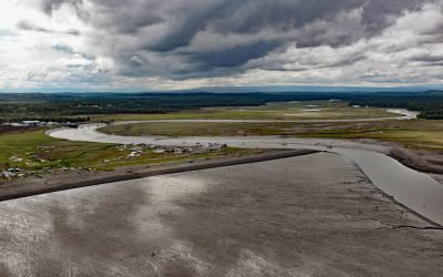
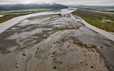
Kasilof River, Kenai Peninsula
Kasilof River starts at the outlet of Tustumena Lake on the Kenai Peninsula and flows generally northwest for 17 miles (27 km) through the Kenai Lowland to Cook Inlet, draining a watershed of 93,275 acres (37,747 ha), about 51 miles (82 km) north-northeast of Homer and 13 miles (21 km) south-southwest of Kenai, Alaska.
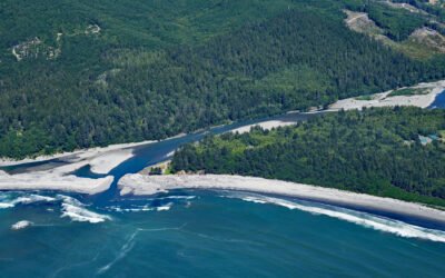
Hoh River, Olympic National Park
Hoh River starts from the terminus of the Hoh Glacier at an elevation of roughly 4,200 feet (1,280 m) on the northeast flank of Mount Olympus in Olympic National Park and flows generally west-southwest for 56 miles (90 km) draining a watershed of 191,360 acres (77,441 ha) to the Pacific Ocean, about 99 miles (159 km) west of Seattle and 15 miles (24 km) south of Forks, Washington.
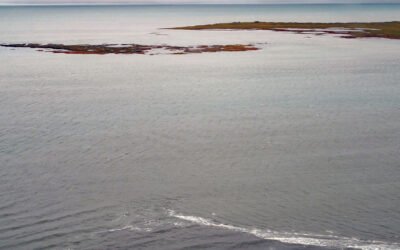
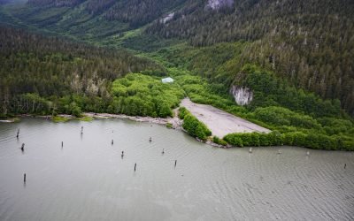
Leffingwell Camp, Flaxman Island
Leffingwell Camp is situated on Flaxman Island, a shape-shifting barrier island separating the Beaufort Sea to the north and Lion Bay to the south, about 58 miles (94 km) east of Deadhorse and 58 miles (94 km) west of Kaktovik, Alaska.
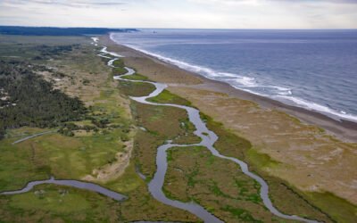
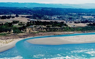
Floras Creek, New River
Floras Creek starts from an elevation of roughly 2,786 feet (849 m) on the north flank of Edson Butte in the Oregon Coast Range and flows generally west for 13 miles (21 km), draining a watershed of 51,652 acres (20,903 ha) to the outlet of Floras Lake where the stream makes a sharp turn to the north and becomes the New River, about 12 miles (19 km) north of Port Orford and 3 miles (5 km) west-southwest of Langlois, Oregon.
Bering River, Controller Bay
Bering River starts from a series of ice-marginal lakes and streams draining from the Martin River, Steller, and Bering glaciers, and flows generally south-southwest for 18 miles ( km) to Controller Bay on the Gulf of Alaska, about 63 miles (102 km) west of Cape Yakutaga and 58 miles (94 km) southeast of Cordova, Alaska.
Scotia River, Great Bear Rainforest
Scotia River starts at an elevation of 5,023 feet (1,531 m) in the Coast Range and flows generally north-northwest for 14 miles (22 km) through the Great Bear Rainforest, draining a watershed of 33,360 acres (13,500 ha) to the southern shore, or left bank, of the Skeena River, about 49 miles (79 km) southwest of Terrace and 29 miles (47 km) east-southeast of Prince Rupert, British Columbia.
Mad River, McKinleyville
Mad River starts in the Coast Range at an elevation of 4,845 ft (1,477 m) and flows generally northwest for 113 miles (182 km), draining a watershed of 318,080 acres (128,722 ha), and enters the Pacific Ocean about 12 miles (19 km) north of Eureka and 1.8 miles (3 km) northwest of McKinleyville, California.
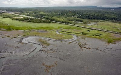
Rabbit Creek, Potter Marsh
Rabbit Creek starts at the outlet of Rabbit Lake, at the base of the west flank of North Yuyanq’ Ch’ex in the Chugach Mountains at an elevation of 3,082 feet (940 m), and flows generally west-northwest for 26 miles (42 km) draining a watershed of 9,152 acres (3,704 ha) to Potter Marsh where it merges with Little Rabbit Creek and discharges into Turnagain Arm, about 13 miles (21 km) northwest of Hope and 10 miles (16 km) south-southeast of downtown Anchorage, Alaska.
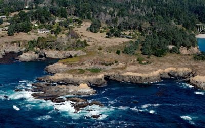
Devil’s Punchbowl, Russian Gulch State Park
Devil’s Punchbowl is a sinkhole formed by a collapsed sea cave over 70 feet (21 m) deep and 100 feet (30 m) in diameter near the mouth of Russian Gulch Creek in Russian Gulch State Park, about 8 miles (13 km) south of Fort Bragg and 1.6 miles (2.6 km) north-northwest of Mendocino, California.
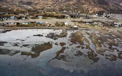
Chignik Lagoon, Alaska Peninsula
Chignik Lagoon is an embayment that trends southwest for 8.5 miles (14 km) from the head of Chignik Bay to the mouth of Chignik River on the Gulf of Alaska coast of the Alaska Peninsula, about 45 miles (73 km) south of Port Heiden and 5 miles (8 km) west-northwest of the community of Chignik, Alaska.
About the background graphic
This ‘warming stripe’ graphic is a visual representation of the change in global temperature from 1850 (top) to 2019 (bottom). Each stripe represents the average global temperature for one year. The average temperature from 1971-2000 is set as the boundary between blue and red. The colour scale goes from -0.7°C to +0.7°C. The data are from the UK Met Office HadCRUT4.6 dataset.
Click here for more information about the #warmingstripes.