Shipwrecks
Recent Articles
More Articles
Cape Pankof, Ikatan Peninsula
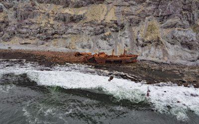
Cape Pankof is a point of land situated at the eastern tip of the lkatan Peninsula on Unimak Island and the site of the shipwrecked SS Oduna, about 148 miles (239 km) northeast of Dutch Harbor and 18 miles (29 km) southeast of False Pass, Alaska.
Siuslaw River, Florence
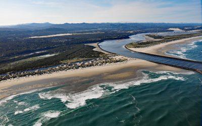
Siuslaw River starts at an elevation of 636 feet (194 m) in the Coast Range and flows generally west-northwest for 110 miles (177 km) to the Pacific Ocean at Florence, draining a watershed of 494,720 acres (200,206 ha), about 53 miles (85 km) west of Eugene and 43 miles (69 km) south of Newport, Oregon.
Corea Creek, Clam Gulch
Corea Creek drains a fen at an elevation of 200 feet (60 m) on the Kenai Peninsula and flows generally southwest for 2.4 miles (4 km) to the eastern shore of Cook Inlet and the site of a historic shipwreck, about 37 miles (60 km) north of Homer and 5 miles (8 km) south-southwest of Clam Gulch, Alaska.
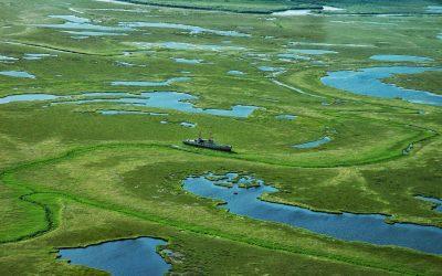
Admiralty Trading Company, Gambier Bay
Gambier Bay is the site of an infamous shipwreck and a historical salmon cannery operated by Admiralty Trading Company near Stephens Passage on the east coast of Admiralty Island, about 61 miles ( km) northwest of Petersburg and 59 miles (km) south-southeast of Juneau, Alaska.
Peter Iredale, Clatsop Spit
Peter Iredale was a British four-masted bark-rigged sailing ship with a length of 275 feet (84 m) that ran aground in 1906 and wrecked on Clatsop Spit, about 7 miles (11 km) west of Astoria and 2 miles ( km) southwest of Hammond, Oregon.
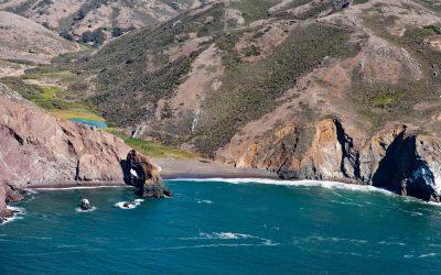
Tennessee Cove, Golden Gate National Recreation Area
Tennessee Cove is an embayment with a sandy beach about 600 feet (180 m) long on the Pacific Ocean between Pirates Cove to the north and Rodeo Cove to the south in Golden Gate National Recreation Area about 10 miles (16 km) northwest of San Francisco and 3.6 miles (5.8 km) southwest of Mill Valley, California.
Dangerous Cape, Port Graham
Dangerous Cape is a headland with an elevation of 66 feet (20 m) on the southern Kenai Peninsula, at the northern entrance of Port Graham near the mouth of Kachemak Bay, about 22 miles (35 km) southwest of Homer and 4 miles (6.5 km) northwest of the community of Port Graham, Alaska.
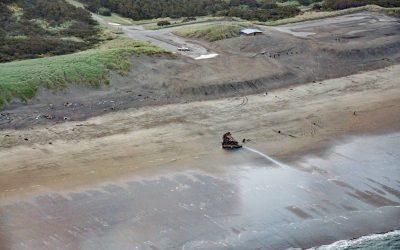
King Philip, Ocean Beach
King Philip was a clipper ship that wrecked in 1878 on Ocean Beach, on the west coast of the San Francisco Peninsula in the Sunset District, about 1 mile (1.6 km) south of Golden Gate Park and 7 miles (11 km) west-southwest of downtown San Francisco, California.
Twin Hills, Togiak Bay
Twin Hills is a Yup’ik village situated on a distributary channel of the Togiak River at the head of Togiak Bay, about 130 miles (210 km) southeast of Bethel and 64 miles (103 km) west of Dillingham, Alaska.
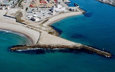
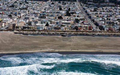
La Jenelle, Silver Strand
La Jenelle was a passenger ship that went aground and wrecked in 1970 on Silver Strand at Port Hueneme, a sandy beach created partly from dredged harbor sand about 1 mile (1.6 km) long and 450 feet(140 m) wide, about 33 miles (53 km) southeast of Santa Barbara and 3.3 miles (5.3 km) south of Oxnard, California.
About the background graphic
This ‘warming stripe’ graphic is a visual representation of the change in global temperature from 1850 (top) to 2019 (bottom). Each stripe represents the average global temperature for one year. The average temperature from 1971-2000 is set as the boundary between blue and red. The colour scale goes from -0.7°C to +0.7°C. The data are from the UK Met Office HadCRUT4.6 dataset.
Click here for more information about the #warmingstripes.