
British Columbia
Recent Articles
More Articles
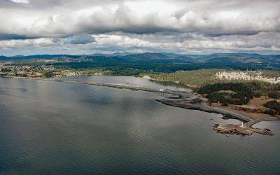
Esquimalt Lagoon, Royal Roads
Esquimalt Lagoon is formed by the Coburg Peninsula, a sand and gravel barrier spit 1.2 miles (1.9 km) long at Royal Roads on Vancouver Island, about 4.4 miles (7.3 km) west of Victoria in the city of Colwood, British Columbia.

Cape Scott, Cape Scott Provincial Park
Cape Scott is a headland about 500 feet (150 m) high at the extreme northwestern point of Vancouver Island in Cape Scott Provincial Park, about 256 miles 412 km) south-southeast of Prince Rupert and 41 miles (66 km) west of Port Hardy, British Columbia.
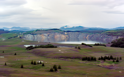
Island Copper Mine, Rupert Inlet
Island Copper was an open pit mine located at the northern end of Vancouver Island on Rupert Inlet at the head of Quatsino Sound, about 4.6 miles (7.4 km) east of Coal Harbour and 8.5 miles (14 km) south of Port Hardy, British Columbia.

Pachena Point Lighthouse, Pacific Rim National Park Reserve
Pachena Point Light Station is located on the west coast of Vancouver Island in Pacific Rim National Park Reserve, about 82 miles (132 km) northwest of Victoria and 8 miles (13 km) south-southeast of Bamfield, British Columbia.

Staines Point, Trial Islands
Staines Point is the southern tip of the Trial Islands which comprise two islets separated by a narrow channel situated in the Strait of Juan de Fuca about 0.5 miles (0.8 km) offshore from the southern end of Vancouver Island at McNeill Bay, about 3.5 miles (5.6 km) southeast of Victoria and 2 miles (3.2 km) south-southeast of Oak Bay, British Columbia.

Butedale, Princess Royal Island
Butedale is a historical salmon cannery and community located on a small embayment adjacent to Butedale Falls along the Inside Passage on the northeast side of Princess Royal Island across from Work Island on the southern shore of Fraser Reach, which is part of Princess Royal Channel, about 103 miles (166 km) southeast of Prince Rupert and 59 miles (95 km) south of Kitimat, British Columbia.

Siwash Rock, Stanley Park
Siwash Rock is a sea stack on the western shoreline of Stanley Park in Burrard Inlet, between English Bay to the south and the entrance to Vancouver Harbour to the north, about 3 miles (5 km) northwest of downtown Vancouver, British Columbia.
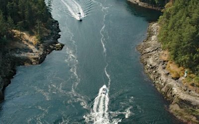
Dodd Narrows, Mudge Island
Dodd Narrows is at the northwest end of Mudge Island separating Mudge Island from Vancouver Island, about 33 miles (53 km) southwest of Vancouver and 6 miles (9.7 km) southeast of Nanaimo, British Columbia.

Gonzales Bay, Victoria
Gonzales Bay is on Vancouver Island and the northern shore of the Strait of Juan de Fuca, situated between Ross Bay to the west and McNeill Bay to the east, and is also the name of a neighborhood about 1.4 miles (2.3 km) southwest of Oak Bay and 2 miles (3.2 km) southeast of downtown Victoria, British Columbia.

James Island, Southern Gulf Islands
James Island is one of the Southern Gulf Islands located in Haro Strait between Cordova Channel to the west and Sidney Channel to the east, about 12 miles (19 km) north of Victoria and 4 miles (6.5 km) southeast of Sidney, British Columbia.
About the background graphic
This ‘warming stripe’ graphic is a visual representation of the change in global temperature from 1850 (top) to 2019 (bottom). Each stripe represents the average global temperature for one year. The average temperature from 1971-2000 is set as the boundary between blue and red. The colour scale goes from -0.7°C to +0.7°C. The data are from the UK Met Office HadCRUT4.6 dataset.
Click here for more information about the #warmingstripes.