Beaches
Recent Articles
More Articles
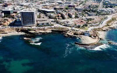
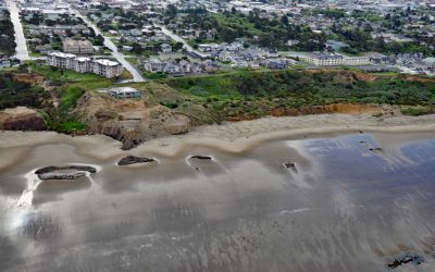
Childrens Pool, La Jolla
Children’s Pool was one of the many gifts that philanthropist Ellen Browning Scripps gave to the community of La Jolla, about 13 miles (21 km) south of Encinitas and 11.4 miles (18 km) northwest of San Diego, California.

Maple Bay, Sansum Narrows
Maple Bay is a community located on Sansum Narrows, a narrow inlet in the Salish Sea that separates Vancouver Island from Salt Spring Island, about 29 miles (47 km) northwest of Victoria and 28 miles (45 km) southeast of Nanaimo, British Columbia.

Salmon Creek, Sonoma Coast State Park
Salmon Creek starts at an elevation of 570 feet (174 m) and flows generally southwest for 19 miles (31 km) draining a watershed of 22,487 acres (9,100 ha) between the Northern Coast Ranges and the Pacific Ocean at Salmon Creek Beach in Sonoma Coast State Park, about 20 miles (32 km) southwest of Santa Rosa and 2 miles (3.2 km) northwest of Bodega Bay, California.
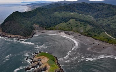
Hunters Cove, Cape Sebastian
Hunters Cove is on the south side of Cape Sebastian, a prominent headland in Cape Sebastian State Scenic Corridor, about 20 miles (32 km) north-northwest of Brooking and 6.3 miles (10 km) south of Gold Beach, Oregon.
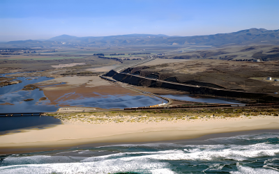
Surf Beach, Santa Ynez River
Surf Beach is within Vandenberg Space Force Base and extends south-southwest for about 4.5 miles (7.3 km) from the mouth of the Santa Ynez River estuary to Spring Canyon, about 31 miles (50 km) south of Pismo Beach and 9 miles (14.5 km) west-northwest of Lompoc, California.
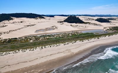
Umpqua Beach, Oregon Dunes National Recreation Area
Umpqua Beach is an off-highway vehicle staging area south of the Umpqua River mouth in the Oregon Dunes National Recreation Area that extends for about 35 miles (56 km) along the coast from the Siuslaw River at Florence in the north to the Coos River at North Bend, Oregon.
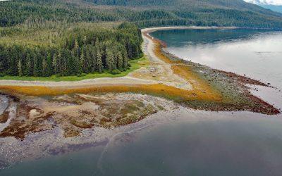
Sumdum, Endicott Arm
Sumdum is a historical Tlingit village of the S’awdaan Kwáan located north of Powers Creek at the northern end of Endicott Arm where it meets Holkham Bay in Tracy Arm-Fords Terror Wilderness, about 70 miles (113 km) north-northwest of Petersburg and 49 miles (79 km) southeast of Juneau, Alaska.
Nye Beach, Newport
Nye Beach is situated in Newport between Agate Beach to the north and Yaquina Beach to the south, and historically was demarcated at the north end by a rocky point with a sea stack known as Jump-Off Joe, about 22 miles (35 km) south of Lincoln City and 1.9 miles (3 km) north of Yaquina Bay, Oregon
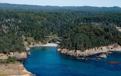
Russian Gulch, Mendocino Coast
Russian Gulch is a river that starts at an elevation of about 800 feet (244 m) on the northwestern flank of Hi Chute Ridge in the California Coast Ranges and flows generally northwest for 5 miles (8 km) to the Pacific Ocean, draining a watershed of 2,456 acres (994 ha) in Russian Gulch State Park, about 2 miles (3.3 km) north of Mendocino and 7 miles (11 km) south of Fort Bragg, California.
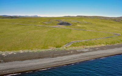
Chariot, Cape Thompson
Cape Thompson is a headland on the Chukchi Sea coast near the site of Project Chariot, about 41 miles (66 km) northwest of Kivalina and about 31 miles (50 km) southeast of Point Hope, Alaska.
About the background graphic
This ‘warming stripe’ graphic is a visual representation of the change in global temperature from 1850 (top) to 2019 (bottom). Each stripe represents the average global temperature for one year. The average temperature from 1971-2000 is set as the boundary between blue and red. The colour scale goes from -0.7°C to +0.7°C. The data are from the UK Met Office HadCRUT4.6 dataset.
Click here for more information about the #warmingstripes.