BEST OF 2023
Clark’s Point, Nushagak Bay
Clark’s Point is the site of a historic community and salmon cannery located on the eastern shore of Nushagak Bay at the mouth of Clark Slough, about 57 miles (92 km) west-northwest of Naknek and 14 miles (23 km) south-southwest of Dillingham, Alaska.

North Dawes Glacier, Endicott Arm
North Dawes Glacier starts from the Stikine Icefield at an elevation of about 5,200 feet (1,585 m) on the western flank of Sheppard Peak and flows generally southwest for 15 miles (24 km) to a proglacial lake at an elevation of 1000 feet (305 m) which is 2 miles (3.2 km) long and drained by a stream 1.3 miles (2.1 km) long at the head of an inlet extending north from Endicott Arm, about 74 miles (119 km) southeast of Juneau and 51 miles (82 km) north of Petersburg, Alaska.

Salmon Creek, Sonoma Coast State Park
Salmon Creek starts at an elevation of 570 feet (174 m) and flows generally southwest for 19 miles (31 km) draining a watershed of 22,487 acres (9,100 ha) between the Northern Coast Ranges and the Pacific Ocean at Salmon Creek Beach in Sonoma Coast State Park, about 20 miles (32 km) southwest of Santa Rosa and 2 miles (3.2 km) northwest of Bodega Bay, California.

Old Chenega Village, Chenega Island
Old Chenega is a historical village at the head of Chenega Cove on the southern tip of Chenega Island in western Prince William Sound, which is part of the traditional territory of the Chugach Sugpiaq people, about 82 miles (132 km) west-southwest of Cordova and 40 miles (64 km) southeast of Whittier, Alaska.

Coal Point, Homer Spit
Coal Point forms the tip of the Homer Spit in Kachemak Bay on the southern Kenai Peninsula, about 15 miles (24 km) northeast of Seldovia and 5.7 miles (9 km) southeast of Homer, Alaska.

Tennessee Cove, Golden Gate National Recreation Area
Tennessee Cove is an embayment with a sandy beach about 600 feet (180 m) long on the Pacific Ocean between Pirates Cove to the north and Rodeo Cove to the south in Golden Gate National Recreation Area about 10 miles (16 km) northwest of San Francisco and 3.6 miles (5.8 km) southwest of Mill Valley, California.

Elfin Cove, Chichagof Island
Elfin Cove is an embayment that extends south from Cross Sound for 1 mile (1.6 km) and narrows to just over 100 feet (30 m) on the western shore of the Inian Peninsula at the northern end of Chichagof Island in Tongass National Forest, about 80 miles (129 km) west of Juneau and 34 miles (55 km) northwest of Hoonah, Alaska.

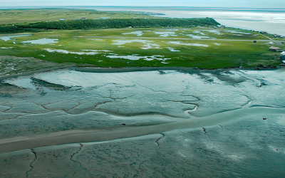
Rolph Slough, Nushagak Point
Rolph, or Ralph Slough is a tidal creek in an area of grass meadows and numerous unnamed sloughs that cut through vast mud flats on the left bank near the mouth of the Nushagak River at Nushagak Point, about 55 miles (89 km) west-northwest of Naknek and 6 miles (10 km) south of Dillingham, Alaska.

Sealing Point, Cape Krusenstern
A sealing observation tower used seasonally by Iñupiat hunters is at the tip of Cape Krusenstern, about 48 miles (77 km) southeast of Kivalina and 35 miles (56 km) northwest of Kotzebue, Alaska.

Kustatan, West Foreland
Kustatan is a historical Dena’ina community on West Foreland, on the west side of Cook Inlet near the mouth of the Kustatan River, about 71 miles (115 km) southwest of Anchorage and 20 miles (32 km) northwest of Kenai, Alaska.
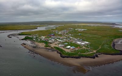
Mekoryuk, Nunivak Island
Mekoryuk is a community situated at the western entrance to Shoal Bay on the northern shore of Nunivak Island in the Bering Sea, about 153 miles (246 km) west-southwest of Bethel and 80 miles (129 km) south of Hooper Bay, Alaska.