Lighthouses
Recent Articles
More Articles
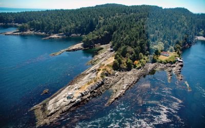
Porlier Pass, Galiano Island
Porlier Pass separates Galiano and Valdes Islands in the Southern Gulf Islands of Georgia Strait, about 28 miles (45 km) southwest of Vancouver and 10 miles (16 km) east-northeast of Ladysmith, British Columbia.
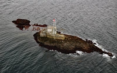
Lincoln Rock Light, Clarence Strait
Lincoln Rock and Lincoln Island are small islets in Clarence Strait in Southeast Alaska, about 63 miles (102 km) northwest of Ketchikan and 31 miles (50 km) southwest of Wrangell, Alaska.
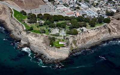
Point Fermin, San Pedro
Point Fermin is the site of a historic lighthouse at the southernmost tip of the Palos Verdes Peninsula in the city of San Pedro, about 25 miles (40 km) southeast of Santa Monica and 7 miles (11 km) southwest of Long Beach, California.
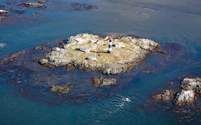
Race Rocks, Strait of Juan de Fuca
Race Rocks is a group of nine islets including North Rock, West Race, Great Race, and Rosedale Rock located about 1 mile (1.6 km) off Cape Calver on the southern tip of Vancouver Island in the Strait of Juan de Fuca, about 12 miles (19 km) southwest of Victoria and 11 miles (18 km) southeast of Sooke, British Columbia.
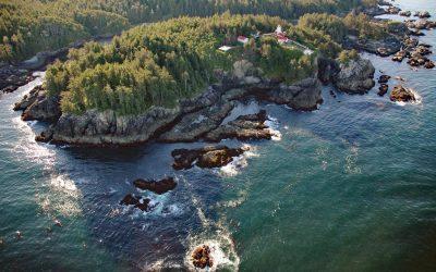
Cape Beale, Barkley Sound
Cape Beale is the site of a historic lighthouse marking the southern entrance to Barkley Sound on the west coast of Vancouver Island in Pacific Rim National Park Reserve, about 89 miles (143 km) west-northwest of Victoria and 4.7 miles (7.6 km) southwest of Bamfield, British Columbia.
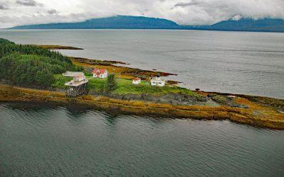
Point Retreat, Admiralty Island
Point Retreat is a headland with a historic lighthouse on the Mansfield Peninsula at the northern tip of Admiralty Island, between Lynn Canal to the west and Saginaw Channel of Stephens Passage to the east, about 60 miles (97 km) south-southeast of Haines and 20 miles (32 km) northwest of Juneau, Alaska.
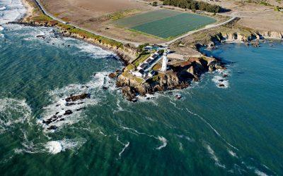
Pigeon Point Lighthouse, Pigeon Point
Pigeon Point is a prominent headland and the site of a historic lighthouse, situated between Bolsa Point to the north and Franklin Point to the south, about 25 miles (40 km) northwest of Santa Cruz and 5 miles (8 km) south of Pescadero, California.
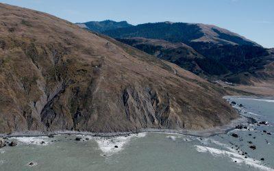
Cape Mendocino, Lost Coast
Cape Mendocino is a major headland on the Lost Coast and the westernmost point in California, situated between Bear River to the north and Mattole River to south, about 210 miles (338 km) northwest of San Francisco, and 28 miles (45 km) southwest of Eureka, California.

Año Nuevo Island, Año Nuevo State Park
Año Nuevo Island is the site of a historic light tower and fog signal on about 9 acres (3.6 ha) and separated from Point Año Nuevo by a shallow channel encompassed by Año Nuevo State Park, about 21 miles (34 km) northwest of Santa Cruz and 11 miles (18 km) south-southeast of Pescadero, California.

Point Bonita, Marin Headlands
Point Bonita is the site of a historic lighthouse situated on the Marin Headlands at the northern entrance to the Golden Gate, about 7 miles (11 km) west-northwest of San Francisco, and 4 miles (7 km) southwest of Sausalito, California.
About the background graphic
This ‘warming stripe’ graphic is a visual representation of the change in global temperature from 1850 (top) to 2019 (bottom). Each stripe represents the average global temperature for one year. The average temperature from 1971-2000 is set as the boundary between blue and red. The colour scale goes from -0.7°C to +0.7°C. The data are from the UK Met Office HadCRUT4.6 dataset.
Click here for more information about the #warmingstripes.