
Climate Change
Recent Articles
More Articles
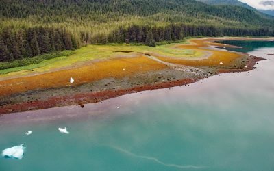
Tracy Arm, Tracy Arm-Fords Terror Wilderness
Tracy Arm is a fjord in the Coast Mountains of Southeast Alaska about 85 miles (137 km) northeast of Sitka and 42 miles (67.7 km) southeast of Juneau, Alaska.
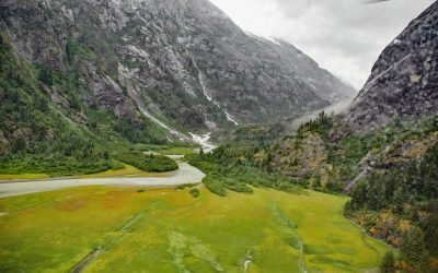
North Dawes Glacier, Endicott Arm
North Dawes Glacier starts from the Stikine Icefield at an elevation of about 5,200 feet (1,585 m) on the western flank of Sheppard Peak and flows generally southwest for 15 miles (24 km) to a proglacial lake at an elevation of 1000 feet (305 m) which is 2 miles (3.2 km) long and drained by a stream 1.3 miles (2.1 km) long at the head of an inlet extending north from Endicott Arm, about 74 miles (119 km) southeast of Juneau and 51 miles (82 km) north of Petersburg, Alaska.

Yahtse Glacier, Icy Bay
Yahtse Glacier starts from the south flank of Mount Miller in Barkley Ridge at an elevation of 8,200 feet (2,500 m) and flows generally southeast for 40 miles (65 km) through Wrangell-Saint Elias National Park and Preserve to a tidewater terminus between Guyot Hills to the west and Karr Hills to the east in Icy Bay, about 152 miles (245 km) east-southeast of Cordova and 71 miles (115 km) northwest of Yakutat, Alaska.

North Sawyer Glacier, Tracy Arm
Sawyer Glacier, also called North Sawyer Glacier, starts in the Coast Mountains of British Columbia at an elevation of about 6,600 feet (2,012 m) and flows generally west for 14 miles (23 km) to the Alaska border at an elevation of 3,600 feet (1,097 m) and then another 7 miles (11 km) to a terminus at sea level in Tracy Arm, about 78 miles (126 km) north of Petersburg and 53 miles (85 km) southeast of Juneau, Alaska.
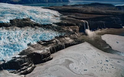
Kashteen Peninsula, Tsaa Fjord
Kashteen Peninsula is located in Wrangell-Saint Elias National Park and Preserve on the eastern shore of Icy Bay, between Tsaa Fjord to the south and Guyot Fjord to the north, and is emerging from under the retreating Guyot Glacier, about 149 miles (240 km) east-southeast of Cordova and 73 miles (118 km) northwest of Yakutat, Alaska.

Guyot Glacier, Icy Bay
Guyot Glacier starts from an elevation of about 6,700 feet (2,042 m) on the eastern flank of Yaga Peak in the Robinson Mountains and flows generally east-southeast for 34 miles (55 km) to its terminus just south of the Guyot Hills on the western shore of Icy Bay in Wrangell-Saint Elias National Park and Preserve, about 146 miles (235 km) east-southeast of Cordova and 76 miles (123 km) northwest of Yakutat, Alaska.

Sumdum Glacier, Powers Creek
Sumdum Glacier starts on the south flank of Mount Sumdum with a summit elevation of 6,666 feet (2,032 m) and flows southwest to a hanging terminus at 2,100 feet (640 m) and the start of Powers Creek that flows 2 miles (3.2 km) to the eastern shore of Endicott Arm, about 89 miles (144 km) northeast of Sitka and 50 miles (81 km) southeast of Juneau, Alaska.
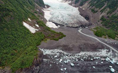
Tigertail Glacier, Nassau Fjord
Tigertail Glacier starts at an elevation of about 2,850 feet (869 m) in the Sargent Icefield on the Kenai Peninsula and flows generally northeast for 3.3 miles (5.3 km) and terminates 0.2 miles (0.3 km) from the western shore of Nassau Fjord, which is a northern arm of Icy Bay in western Prince William Sound, about 36 miles (58 km) east-northeast of Seward and 36 miles (58 km) south-southeast of Whittier, Alaska.
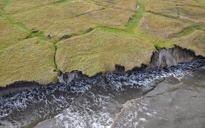
Drew Point, Smith Bay
Drew Point is located at the eastern entrance to Smith Bay on the Beaufort Sea and is formed by rapidly eroding permafrost and ice wedges at the edge of the Arctic Coastal Plain, about 81 miles (131 km) northwest of Nuiqsut and 70 miles (113 km) southeast of Utqiaġvik, Alaska.
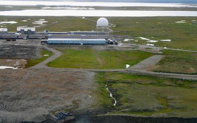
North Warning System, Barter Island
The North Warning System at Barter Island is a long-range radar facility on the Beaufort Sea coast, situated between Arey Lagoon to the west and Kaktovik Lagoon to the east and adjacent to the village of Kaktovik, about 273 miles (440 km) northwest of Inuvik, Northwest Territories, and 112 miles (180 km) east of Deadhorse, Alaska.
About the background graphic
This ‘warming stripe’ graphic is a visual representation of the change in global temperature from 1850 (top) to 2019 (bottom). Each stripe represents the average global temperature for one year. The average temperature from 1971-2000 is set as the boundary between blue and red. The colour scale goes from -0.7°C to +0.7°C. The data are from the UK Met Office HadCRUT4.6 dataset.
Click here for more information about the #warmingstripes.