
Parks
Recent Articles
More Articles
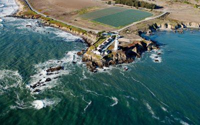
Pigeon Point Lighthouse, Pigeon Point
Pigeon Point is a prominent headland and the site of a historic lighthouse, situated between Bolsa Point to the north and Franklin Point to the south, about 25 miles (40 km) northwest of Santa Cruz and 5 miles (8 km) south of Pescadero, California.

Tyndall Glacier, Taan Fjord
Tyndall Glacier starts at an elevation of about 10,000 feet (3,050 m) in the Saint Elias Mountains near the Canadian border, between Mount Huxley to the west and Mount Saint Elias to the east, and flows generally south-southwest for 13 miles (21 km) to the head of Taan Fjord in Icy Bay, about 160 miles (258 km) east-southeast of Cordova and 68 miles (110 km) northwest of Yakutat, Alaska.
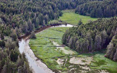
South Slough, Coos Bay
South Slough is a tidal embayment designated as a National Estuarine Research Reserve that extends 6 miles (10 km) south from Coos Bay, which is an estuary of the Coos River, about 13 miles (21 km) north-northeast of Bandon and 4 miles (6.5 km) south of Charleston, Oregon.
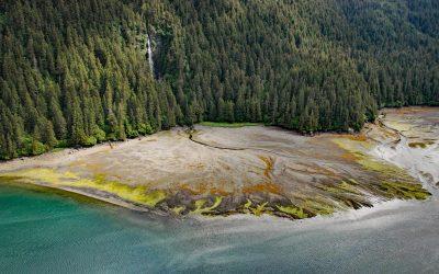
Tutka Bay, Kachemak Bay State Park
Tutka Bay is a deglaciated fjord that extends 8.5 miles (14 km) in Kachemak Bay State Park from Eldred Passage to the mouth of an unnamed river that flows generally west-northwest for 7 miles (11 km) from small remnants of the Southern Glacier, about 18 miles (29 km) southeast of Homer and 15 miles (24 km) east of Seldovia, Alaska.
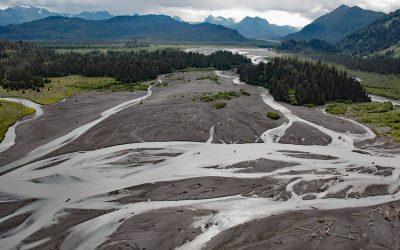
McKeon Flats, Wosnesenski River
McKeon Flats is formed by the Wosnesenski River that flows into Neptune Bay on the south shore of Kachemak Bay on the Kenai Peninsula, about 14 miles (23 km) northeast of Seldovia and 9 miles (14.5 km) southeast of Homer, Alaska.

Año Nuevo Island, Año Nuevo State Park
Año Nuevo Island is the site of a historic light tower and fog signal on about 9 acres (3.6 ha) and separated from Point Año Nuevo by a shallow channel encompassed by Año Nuevo State Park, about 21 miles (34 km) northwest of Santa Cruz and 11 miles (18 km) south-southeast of Pescadero, California.
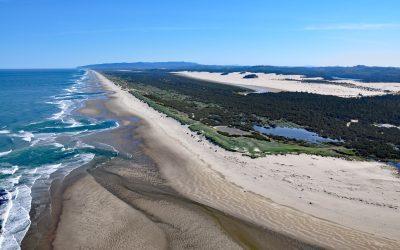
Siltcoos River, Oregon Coastal Dunes
Siltcoos River begins at the outlet of Siltcoos Lake and meanders generally west for 3 miles (4.8 km) through the Oregon Coastal Dunes to the Pacific Ocean, about 8 miles (13 km) south of Florence and 13 miles (21 km) north of Reedsport, Oregon.

Point Bonita, Marin Headlands
Point Bonita is the site of a historic lighthouse situated on the Marin Headlands at the northern entrance to the Golden Gate, about 7 miles (11 km) west-northwest of San Francisco, and 4 miles (7 km) southwest of Sausalito, California.

North Head, Ilwaco
North Head is a rocky promontory with a summit elevation of 300 feet (91 m) and the site of a historic lighthouse situated on Cape Disappointment at the mouth of the Columbia River between Baker Bay to the east and the Pacific Ocean to the west, about 14 miles (23 km) northwest of Astoria and 2 miles (3.2 km) southwest of Ilwaco, Washington.

Point Reyes, Point Reyes National Seashore
Point Reyes is a prominent headland with a historic lighthouse located in Point Reyes National Seashore, a park and nature preserve of 71,028 acres (28,744 ha), about 35 miles (56 km) northwest of San Francisco and 12 miles (19 km) southwest of Inverness, California.
About the background graphic
This ‘warming stripe’ graphic is a visual representation of the change in global temperature from 1850 (top) to 2019 (bottom). Each stripe represents the average global temperature for one year. The average temperature from 1971-2000 is set as the boundary between blue and red. The colour scale goes from -0.7°C to +0.7°C. The data are from the UK Met Office HadCRUT4.6 dataset.
Click here for more information about the #warmingstripes.