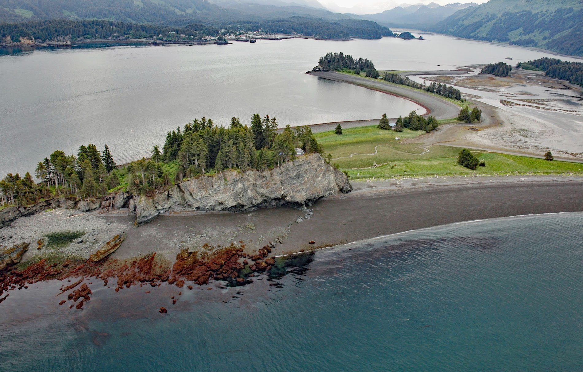
Point Naskowhak was an island that is now connected to the mainland of the Kenai Peninsula by a tombolo or spit, creating a tied island at the western entrance to Seldovia Bay, about 15 miles southwest of Homer and 1.5 miles (2.4 km) northwest of Seldovia, Alaska. The name is from the Alutiiq language word ‘Nasquruaq’ meaning ‘a head-like point’ and was first reported by the U.S. Coast and Geodetic Survey in 1908 as ‘Naskowhak’. The relatively resistant rock of Point Naskowhak is part of the Tyonek Formation, non-marine strata in the Cook Inlet basin that was formed during the Neogene and is exposed in Kachemak Bay at coastal formations between Barabara Point and Coal Cove. The Neogene is a geologic period that started about 23 million years ago and ended about 3 million years ago. During this period mammals and birds evolved into modern forms while other groups of life remained relatively unchanged. Early hominids, the ancestors of humans, appeared in Africa near the end of the Neogene. Identification of fossils from Point Naskowhak indicates well-preserved bivalves in sandstones that include features suggestive of rapid deposition in relatively deep water indicating short transport paths between the shallow water source area for the fauna and the depositional site. The island rock is primarily interbedded poorly-sorted pebble conglomerate, sandstone, and minor mudstone.
The tombolo connecting Point Naskowhak to the mainland is a spit that developed as an accretional feature of sand, pebbles, and cobbles eroded from sea cliffs. These sediments are transported and deposited by waves that strike the coast at an oblique angle. Most spits grow in the direction of predominant longshore sediment transport and are often a continuation of a beach adjacent to the coast. Some spits may depart from the trend of the coast and align nearly at right angles to the prevailing wave direction. The free end of the spit may terminate at an island, such as Point Naskowhak, or wave refraction may cause the spit to recurve. Spits are most common on irregular coasts where they grow across bay mouths, confining the bay to a tidal inlet. Nearby examples include MacDonald Spit and Homer Spit. The growth of spits in this way is an important factor in smoothing an initially irregular coastline.
The first salmon trap was built in Cook Inlet in about 1885. It was patterned after the pound nets used in the Great Lakes fisheries but was modified considerably to withstand strong tidal currents and waves. This type of salmon trap became known as a pile trap because whole log piles were driven into the sandy bottoms to support the trap and the webbing and wire netting were fastened to piles to form the walls. The first trap was so successful that more were built in other areas including Kachemak Bay which had 4 traps; one on the north shore between Travers Creek and Diamond Creek, and three on the south shore at MacDonald Spit, Point Naskowhak, and adjacent to Flat Island on the mainland. By the 1930s, the fish traps were owned by the Fidalgo Island Packing Company, which also operated the cannery at Port Graham. Read more here and here. Explore more of Point Naskowhak here:

