Communities
Recent Articles
More Articles

Excursion Inlet, Icy Strait
Excursion Inlet is an embayment that extends 11 miles (18 km) north-northwest from the northern coast of Icy Strait to the mouth of Excursion River, about 38 miles (61 km) west-northwest of Juneau and 9.5 miles (15 km) east of Gustavus, Alaska.

Butedale, Princess Royal Island
Butedale is a historical salmon cannery and community located on a small embayment adjacent to Butedale Falls along the Inside Passage on the northeast side of Princess Royal Island across from Work Island on the southern shore of Fraser Reach, which is part of Princess Royal Channel, about 103 miles (166 km) southeast of Prince Rupert and 59 miles (95 km) south of Kitimat, British Columbia.

SS Palo Alto, Seacliff Beach
SS Palo Alto is a shipwreck that now serves as an artificial reef for marine life at Seacliff State Beach on the northern coast of Monterey Bay, about 6.4 miles (10.3 km) east of Santa Cruz and 0.9 miles (1.5 km) southwest of Aptos, California.

Siwash Rock, Stanley Park
Siwash Rock is a sea stack on the western shoreline of Stanley Park in Burrard Inlet, between English Bay to the south and the entrance to Vancouver Harbour to the north, about 3 miles (5 km) northwest of downtown Vancouver, British Columbia.

Gonzales Bay, Victoria
Gonzales Bay is on Vancouver Island and the northern shore of the Strait of Juan de Fuca, situated between Ross Bay to the west and McNeill Bay to the east, and is also the name of a neighborhood about 1.4 miles (2.3 km) southwest of Oak Bay and 2 miles (3.2 km) southeast of downtown Victoria, British Columbia.
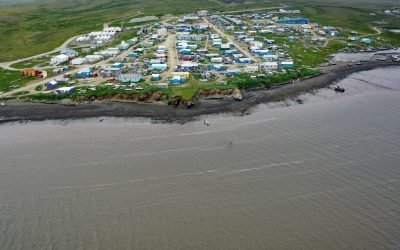
Toksook Bay, Nelson Island
Toksook Bay is a Yup’ik community on Nelson Island, in the Yukon-Kuskokwim Delta, about 112 miles (181 km) west-southwest of Bethel and 13.5 miles (22 km) west-northwest of Nightmute, Alaska.
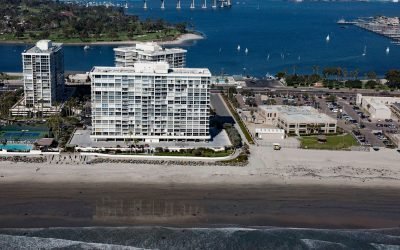
SS Monte Carlo, Coronado Shores
The shipwreck of the SS Monte Carlo is occasionally exposed by shifting sands during the winter on Coronado Shores, a wide sandy beach also known as South Beach, on Coronado Island about 4.5 miles (7.3 km) east of Point Loma and 3.4 miles (5.5 km) south of San Diego, California.
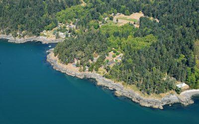
Doe Bay, Orcas Island
Doe Bay is a small community on the southeastern shore of Orcas Island in the San Juan Islands of Puget Sound, about 7 miles (11.3 km) southeast of the community of Eastsound, and 3 miles (4.8 km) northeast of Olga, Washington.
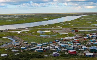
Scammon Bay, Kun River
Scammon Bay is a small community at the base of the Askinuk Mountains, on the left bank and about 1 mile (1.6 km) upstream from the mouth of the Kun River in the Yukon-Kuskokwim Delta, about 147 miles (237 km) northwest of Bethel and 73 miles (118 km) southwest of Emmonak, Alaska.

King Cove, Alaska Peninsula
King Cove is a small community on the Alaska Peninsula located partially on a spit separating King Cove Bay and King Cove Lagoon, about 18 air miles (29 km) southeast of the village of Cold Bay, Alaska.
About the background graphic
This ‘warming stripe’ graphic is a visual representation of the change in global temperature from 1850 (top) to 2019 (bottom). Each stripe represents the average global temperature for one year. The average temperature from 1971-2000 is set as the boundary between blue and red. The colour scale goes from -0.7°C to +0.7°C. The data are from the UK Met Office HadCRUT4.6 dataset.
Click here for more information about the #warmingstripes.