Historical Sites
Recent Articles
More Articles
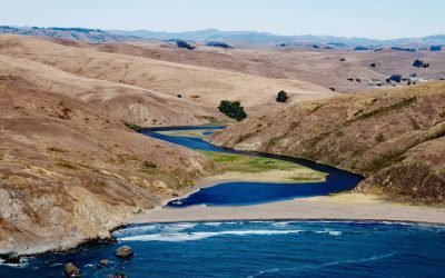
Estero de San Antonio, Bodega Bay
Estero de San Antonio is a small coastal lagoon formed by a sand bar that dams Stemple Creek, a stream that starts in the hills of Marin and Sonoma Counties and flows generally west to Bodega Bay near the mouth of Tomales Bay, 5.75 miles (9 km) southeast of the community of Bodega Bay and 1.5 mi (2.4 km) northwest of Dillon Beach, California.
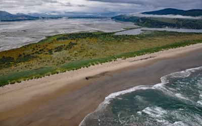
Bayocean, Tillamook Bay
Bayocean was a planned resort community founded in 1906 on a sand spit 4 miles, (6.5 km) long and 0.5 miles (0.8 km) wide, that separates Tillamook Bay from the Pacific Ocean, about 63 miles (102 km) west of Portland and 7 miles (11 km) northwest of Tillamook, Oregon.
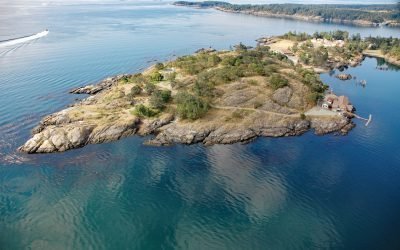
Quarantine Cove, William Head
Quarantine Cove is a bight on the northern shore of William Head, a peninsula near the southern tip of Vancouver Island on the north coast of the Strait of Juan de Fuca, located between Pedder Bay to the south and Parry Bay to the north, approximately 9.7 miles (15.6 km) east-southeast of Sooke and 9.6 miles (15.5 km) southwest of Victoria, British Columbia.

Pilot Point, Ugashik Bay
Pilot Point is a community on the eastern shore of Ugashik Bay, on the north coast of the Alaska Peninsula, 83 miles (134 km) south-southwest of King Salmon and 7 miles (11 km) northwest of Ugashik, Alaska.
Port Camden, Kuiu Island
Port Camden is an embayment on the northeast coast of Kuiu Island, about 36 miles (58 km) south-southwest of Petersburg, and 61 miles (98 km) northwest of Wrangell, Alaska.
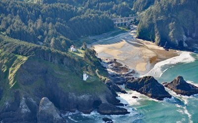
Heceta Head Lighthouse, Heceta Head
Heceta Head Lighthouse is at an elevation of 205 feet (62 m) on the Heceta headland, about 13 miles (21 km) north of Florence, and 13 miles (21 km) south of Yachats, Oregon.
Skeena City, Khyex River
Skeena City is an abandoned community on the north shore of the Skeena River, at the mouth of the Khyex River, 22 miles (35 km) south-southeast of Prince Rupert, and 52 miles (84 km) southwest of Terrace, British Columbia.

Todd Cannery, Peril Strait
Todd is an abandoned cannery and a historical settlement on Lindenberg Harbor in Peril Strait, on the southern coast of Chichagof Island, 9 miles (15 km) west of Chatham Strait and 32 air miles (52 km) north-northeast of Sitka, Alaska.
Daykins Bay, Nitinat Lake
Daykins Bay is on the southeastern shore of Nitinat Lake, approximately 7 miles (11 km) northeast of the outlet at Whyac and 6 miles (10 km) southwest from the Ditidaht village of Malachan, British Columbia.
Uyak Bay, Kodiak Island
Uyak Bay extends south-southeast for 40 miles (65 km) from Shelikof Strait on the northwest coast of Kodiak Island, about 59 miles (95 km) west-southwest of Kodiak, Alaska.
About the background graphic
This ‘warming stripe’ graphic is a visual representation of the change in global temperature from 1850 (top) to 2019 (bottom). Each stripe represents the average global temperature for one year. The average temperature from 1971-2000 is set as the boundary between blue and red. The colour scale goes from -0.7°C to +0.7°C. The data are from the UK Met Office HadCRUT4.6 dataset.
Click here for more information about the #warmingstripes.