Historical Sites
Recent Articles
More Articles

Canadian Fishing Company, Prince Rupert
The Canadian Fishing Company operates fish processing plants on Prince Rupert Harbour at Seal Cove and at George Hills Way, about 89 miles (143 km) southeast of Ketchikan and 72 miles (116 km) west-southwest of Terrace, British Columbia.

McArthur River, Trading Bay
McArthur River flows southeast to Trading Bay on the west coast of Cook Inlet, approximately 65 miles (105 km) southwest of Anchorage and 29 miles (46 km) northwest of Kenai, Alaska.
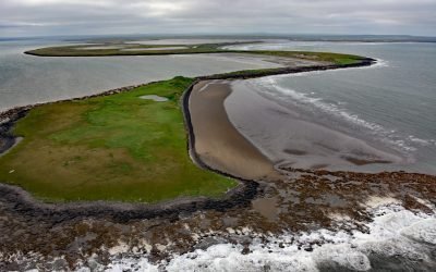
Cape Etolin, Nunivak Island
Cape Etolin is a point of land extending about 4.6 miles (7.4 km) north into the Bering Sea on the northern coast of Nunivak Island, about 50 miles (80 km) west of Nightmute on the mainland and 4 miles (6 km) north-northeast of Mekoryuk, Alaska.
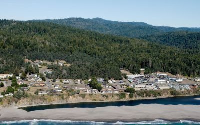
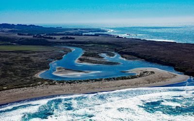
Gualala, Gualala River
The Gualala River flows into the Pacific Ocean at the community of Gualala, approximately 92 miles (148 km) northwest of San Francisco and 40 miles (64 km) south-southeast of Mendocino, California.

Blackstone Glacier, Blackstone Bay
Blackstone Glacier flows north for 7 miles (11 km), terminating at tidewater at the head of Blackstone Bay, about 87 miles (140 km) west-southwest of Valdez and 8 miles (13 km) south of Whittier, Alaska.
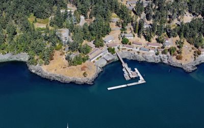
Friday Harbor Laboratories, San Juan Island
Friday Harbor Laboratories is a marine biology field station of the University of Washington situated on the northern shore of Friday Harbor, an embayment on the eastern coast of San Juan Island, about 72 miles (116 km) northwest of Seattle and 18 miles (29 km) west of Anacortes, Washington.
Chugachik Island, Kachemak Bay
Chugachik Island lies between Bear Cove to the south and Martin River to the north on the Kenai Peninsula, about 18 miles (29 km) northeast of Homer and 3.3 miles (5.3 km) south-southeast of Kachemak Selo, Alaska.

Claxton, Telegraph Passage
Claxton is a historical salmon cannery and community at the mouth of Claxton Creek on the eastern shore of Telegraph Passage in the Skeena River estuary, about 66 miles (106 km) southwest of Terrace and 19 miles (31 km) south-southeast of Prince Rupert, British Columbia.

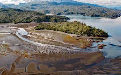
Cataract Glacier, Surprise Inlet
Cataract Glacier flows to the southern shore of Surprise Inlet, a fjord in Prince William Sound, about 51 miles (82 km) east-southeast of Anchorage and 20 miles (32 km) northeast of Whittier, Alaska.
Garcia River, Manchester Beach
The Garcia River flows generally northwest for 44 miles (71 km) to Manchester Beach, north of Point Arena Lighthouse and at Manchester State Park, about 34 miles (55 km) south of Fort Bragg and 4 miles (6.4 km) northwest of the community of Point Arena, California.
About the background graphic
This ‘warming stripe’ graphic is a visual representation of the change in global temperature from 1850 (top) to 2019 (bottom). Each stripe represents the average global temperature for one year. The average temperature from 1971-2000 is set as the boundary between blue and red. The colour scale goes from -0.7°C to +0.7°C. The data are from the UK Met Office HadCRUT4.6 dataset.
Click here for more information about the #warmingstripes.