Historical Sites
Recent Articles
More Articles

Beaver Point, Salt Spring Island
Beaver Point is a prominent headland in Ruckle Provincial Park on the southeastern shore of Salt Spring Island in the Southern Gulf Islands and at the northwestern end of Swanson Channel, about 8 miles (13 km) north-northeast of Sidney and 4 miles (6 km) east of Fulford Harbour, British Columbia.
Limestone Inlet, Stephens Passage
Limestone Inlet, 0.25 miles (0.4 km) wide, extends about 2 miles (3.2 km) into the mainland from the eastern shore of Stephens Passage, approximately 84 miles (135 km) northeast of Sitka and 25 miles (40 km) southeast of Juneau, Alaska.

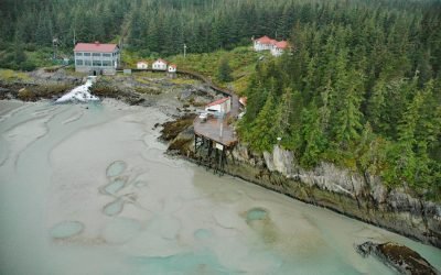
Copper Harbor, Hetta Inlet
Copper Harbor is an embayment on Prince of Wales Island on the eastern shore of Hetta Inlet, near the historical Coppermount mine, about 38 miles (61 km) west-southwest of Ketchikan and 8.6 miles (14 km) east-northeast of Hydaburg, Alaska.
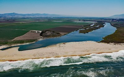
Salinas River, Castroville
The Salinas River begins in the central California Coast Ranges and flows 175 miles (282 km) generally northwest to Monterey Bay, approximately 12 miles (19 km) north-northeast of Monterey and 3 miles (5 km) west-southwest of Castroville, California.

Ford Arm, Chichagof Island
Ford Arm is an embayment approximately 0.3 miles (483 m) wide and 4 miles (6.5 km) long on the west coast of Chichagof Island, about 44 miles (71 km) north-northwest of Sitka and 28 miles (44 km) south-southeast of Pelican, Alaska.
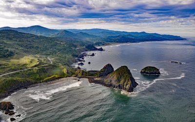
Sisters Rocks, Frankport
Sisters Rocks, historically known as Three Sisters Rocks, is a minor headland located between Mussel Creek to the north and Eucher Creek to the south, about 13 miles (21 km) north of Gold Beach and 11 miles (18 km) south-southeast of Port Orford, Oregon.
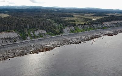
Travers Creek, Kachemak Bay
Travers Creek flows generally west-southwest to the north shore of Kachemak Bay, approximately 3.5 miles (5.5 km) south of Anchor Point and 12 miles (19 km) northwest of Homer, Alaska.
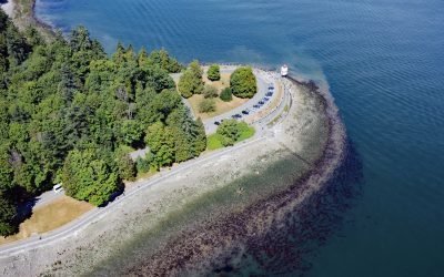
Brockton Point, Stanley Park
Brockton Point is a prominent peninsula in Stanley Park, located on the southern coast of Burrard Inlet, about 19 miles (30 km) north of Tsawwassen and 2.6 miles (4 km) southeast of West Vancouver, British Columbia.
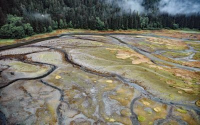
Annex Creek, Taku Inlet
Annex Creek flows southeast for 5 miles (8 km) through the Annex Lakes to Taku Inlet, about 0.35 miles (0.6 km) southwest of the Annex Creek hydroelectric power facility and 12 miles (19 km) east of Juneau, Alaska.

Vassar Glacier, College Fjord
Vassar Glacier flows southeast for 4.3 miles (7 km) from the eastern flank of Peak 8080 in the Chugach Mountains to the western shore of College Fjord near the confluence of Harvard Arm and Yale Arm and 2 miles (3.2 km) west of College Point, about 52 miles (83 km) west of Valdez and 42 miles (68 km) northeast of Whittier, Alaska.
About the background graphic
This ‘warming stripe’ graphic is a visual representation of the change in global temperature from 1850 (top) to 2019 (bottom). Each stripe represents the average global temperature for one year. The average temperature from 1971-2000 is set as the boundary between blue and red. The colour scale goes from -0.7°C to +0.7°C. The data are from the UK Met Office HadCRUT4.6 dataset.
Click here for more information about the #warmingstripes.