Historical Sites
Recent Articles
More Articles
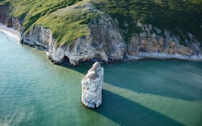
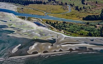
Square Rock, Norton Sound
Square Rock is a marble pillar formed by an eroding sea stack situated about 200 feet (60 m) offshore from the eastern end of Bluff Cliffs on the south coast of the Seward Peninsula in Norton Sound, about 50 miles (80 km) east of Nome and 18 miles (29 km) west of Golovin, Alaska.
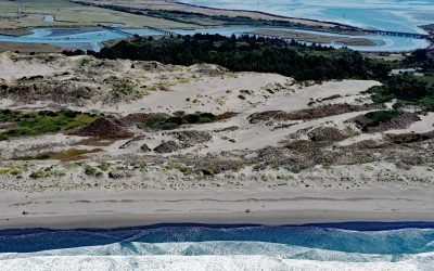
Ma-le’l Dunes, Humboldt Bay
Ma-le’l Dunes, a National Natural Landmark, lie between the Mad River Slough and the Pacific Ocean at the base of the Samoa Peninsula, which partially encloses the northern part of Humboldt Bay, about 1 mile (1.6 km) north of Manila and 3.5 miles (5.6 km) west of Arcata, California.
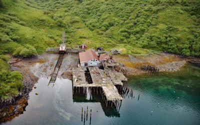
Uganik Fisheries Cannery, Northeast Arm
Uganik Fisheries is a historical salmon cannery on the north shore of Northeast Arm in Uganik Bay on the northwestern coast of Kodiak Island, about 147 miles (237 km) south-southwest of Homer and 35 miles (56 km) west of Kodiak, Alaska.
Northeast Cape, Saint Lawrence Island
Northeast Cape is a headland at the far eastern end of Saint Lawrence Island, formed by the Kinipaghulghat Mountains, between Cape Kulowye to the west and Cape Seevooka to the south, about 133 miles (214 km) southwest of Nome and 96 miles (155 km) east-southeast of Gambell, Alaska.
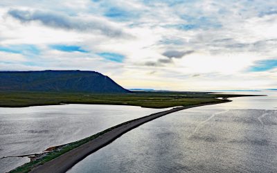
Pysht River, Pillar Point
Pysht River originates near Ellis Mountain on the Olympic Peninsula and flows generally northeast for 16 miles (26 km), draining a watershed of 29,632 acres (11,992 ha), to the Strait of Juan de Fuca at Pillar Point, about 31 miles (50 km) west-northwest of Port Angeles and 26 miles (42 km) southeast of Neah Bay, Washington.
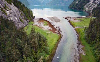
Brim River Hot Springs, Gardner Canal
Brim River Hot Springs and adjoining Owyacumish River Park protect 2,488 acres (1,007 ha) at the head of Owyacumish Bay on the north shore of Gardner Canal, about 96 miles (155 km) southwest of Prince Rupert and 40 miles (64 km) south-southwest of Kitimat, British Columbia.
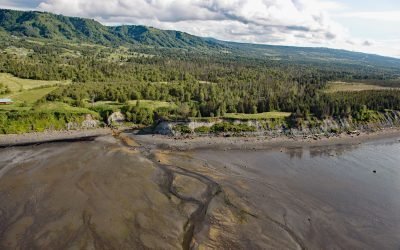
Fritz Creek, Kachemak Bay
Fritz Creek is a stream on the Kenai Peninsula that starts from a watershed divide between Lookout Mountain to the south and Bald Mountain to the north and flows generally south for 7 miles (11 km) to the north shore of Kachemak Bay, about 17 miles (27 km) southeast of Anchor Point and 6 miles (10 km) northeast of Homer, Alaska.
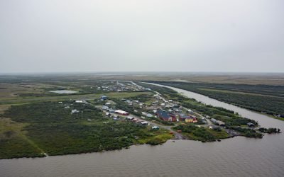
Napakiak, Kuskokwim River
Napakiak is a village located on an island situated between the Kuskokwim River to the south and Johnson Slough to the north, about 167 miles (269 km) southeast of Emmonak and 10 miles (16 km) southwest of Bethel, Alaska.
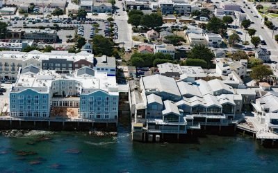
Pacific Biological Laboratories, Cannery Row
Pacific Biological Laboratories is a small, unpainted, two-story wood-frame building toward the northwest end of Cannery Row that served as a biological supply company operated by Edward F. Ricketts from 1937 to 1948, on a small property on Monterey Bay now sandwiched between the Monterey Bay Aquarium and the Intercontinental Hotel in Monterey, California.
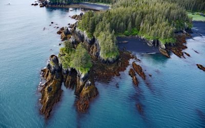
Yalik Point, Nuka Bay
Yalik Point is the site of a historical Alutiiq village in Nuka Bay on the outer coast of the Kenai Peninsula, in present-day Kenai Fjords National Park, about 61 miles (98 km) southwest of Seward and 47 miles (76 km) east of Nanwalek, Alaska.
About the background graphic
This ‘warming stripe’ graphic is a visual representation of the change in global temperature from 1850 (top) to 2019 (bottom). Each stripe represents the average global temperature for one year. The average temperature from 1971-2000 is set as the boundary between blue and red. The colour scale goes from -0.7°C to +0.7°C. The data are from the UK Met Office HadCRUT4.6 dataset.
Click here for more information about the #warmingstripes.