Historical Sites
Recent Articles
More Articles

Old Chenega Village, Chenega Island
Old Chenega is a historical village at the head of Chenega Cove on the southern tip of Chenega Island in western Prince William Sound, which is part of the traditional territory of the Chugach Sugpiaq people, about 82 miles (132 km) west-southwest of Cordova and 40 miles (64 km) southeast of Whittier, Alaska.

Coal Point, Homer Spit
Coal Point forms the tip of the Homer Spit in Kachemak Bay on the southern Kenai Peninsula, about 15 miles (24 km) northeast of Seldovia and 5.7 miles (9 km) southeast of Homer, Alaska.

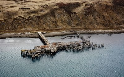
Strogonof Point, Port Heiden
Port Heiden is an embayment on the northern coast of the Alaska Peninsula that extends 9 miles (15 km) southeast from Bristol Bay between Strogonof Point and the community of Port Heiden, to the mouth of the Meshik River, about 147 miles (237 km) south of Dillingham and 45 miles (72 km) north-northwest of Chignik, Alaska.

Peter Iredale, Clatsop Spit
Peter Iredale was a British four-masted bark-rigged sailing ship with a length of 275 feet (84 m) that ran aground in 1906 and wrecked on Clatsop Spit, about 7 miles (11 km) west of Astoria and 2 miles ( km) southwest of Hammond, Oregon.
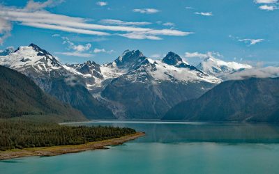
Lituya Bay, Glacier Bay National Park and Preserve
Lituya Bay is a fjord located in Glacier Bay National Park and Preserve on the outer coast of Southeast Alaska, about 97 miles (156 km) southeast of Yakutat and 70 miles (113 km) west-northwest of Gustavus, Alaska.

Tennessee Cove, Golden Gate National Recreation Area
Tennessee Cove is an embayment with a sandy beach about 600 feet (180 m) long on the Pacific Ocean between Pirates Cove to the north and Rodeo Cove to the south in Golden Gate National Recreation Area about 10 miles (16 km) northwest of San Francisco and 3.6 miles (5.8 km) southwest of Mill Valley, California.

Dangerous Cape, Port Graham
Dangerous Cape is a headland with an elevation of 66 feet (20 m) on the southern Kenai Peninsula, at the northern entrance of Port Graham near the mouth of Kachemak Bay, about 22 miles (35 km) southwest of Homer and 4 miles (6.5 km) northwest of the community of Port Graham, Alaska.

Pachena Point Lighthouse, Pacific Rim National Park Reserve
Pachena Point Light Station is located on the west coast of Vancouver Island in Pacific Rim National Park Reserve, about 82 miles (132 km) northwest of Victoria and 8 miles (13 km) south-southeast of Bamfield, British Columbia.
Mutton Cove, Chernofski Harbor
Mutton Cove is an embayment on Unalaska Island about 0.3 miles (0.5 km) across situated on the northern shore of Chernofski Harbor and protected by Observatory Point to the west, about 64 miles (103 km) northeast of Nikolski and 53 miles (85 km) southwest of Dutch Harbor, Alaska.

King Philip, Ocean Beach
King Philip was a clipper ship that wrecked in 1878 on Ocean Beach, on the west coast of the San Francisco Peninsula in the Sunset District, about 1 mile (1.6 km) south of Golden Gate Park and 7 miles (11 km) west-southwest of downtown San Francisco, California.
About the background graphic
This ‘warming stripe’ graphic is a visual representation of the change in global temperature from 1850 (top) to 2019 (bottom). Each stripe represents the average global temperature for one year. The average temperature from 1971-2000 is set as the boundary between blue and red. The colour scale goes from -0.7°C to +0.7°C. The data are from the UK Met Office HadCRUT4.6 dataset.
Click here for more information about the #warmingstripes.