Historical Sites
Recent Articles
More Articles
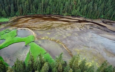
Mink Bay, Boca de Quadra
Mink Bay is an estuary that extends south for 5.4 miles (8.7 km) from Boca de Quadra an embayment on the east side of Revillagigedo Channel, about 54 miles (87 km) north-northwest of Prince Rupert and 40 miles (65 km) southeast of Ketchikan, Alaska.

Lime Kiln Lighthouse, San Juan Island
Lime Kiln Light was established in 1919 on Lime Kiln Point, a day-use park of 36 acres (15 ha) overlooking Deadman Bay to the south and Haro Strait to the west on the west coast of San Juan Island, about 12 miles (19 km) northeast of Victoria and 6.4 miles (10 km) west-southwest of Friday Harbor, Washington.

La Jenelle, Silver Strand
La Jenelle was a passenger ship that went aground and wrecked in 1970 on Silver Strand at Port Hueneme, a sandy beach created partly from dredged harbor sand about 1 mile (1.6 km) long and 450 feet(140 m) wide, about 33 miles (53 km) southeast of Santa Barbara and 3.3 miles (5.3 km) south of Oxnard, California.

SS Yukon, Sanak Island
The steamship Yukon, bound from Goodnews Bay on the Kuskokwim River to Seattle in 1913, ran aground in fog and became a total loss on the northwest end of Sanak Island on what is now called Yukon Reef, about 156 miles (252 km) east-northeast of Dutch Harbor and 48 miles (77 km) south-southwest of King Cove, Alaska.

Excursion Inlet, Icy Strait
Excursion Inlet is an embayment that extends 11 miles (18 km) north-northwest from the northern coast of Icy Strait to the mouth of Excursion River, about 38 miles (61 km) west-northwest of Juneau and 9.5 miles (15 km) east of Gustavus, Alaska.

Butedale, Princess Royal Island
Butedale is a historical salmon cannery and community located on a small embayment adjacent to Butedale Falls along the Inside Passage on the northeast side of Princess Royal Island across from Work Island on the southern shore of Fraser Reach, which is part of Princess Royal Channel, about 103 miles (166 km) southeast of Prince Rupert and 59 miles (95 km) south of Kitimat, British Columbia.
Treadwell Mine, Douglas Island
Treadwell is a historical gold mine on the eastern coast of Douglas Island on Gastineau Channel, about 1.2 miles (1.9 km) southeast of the community of Douglas and 3 miles (4.8 km) southeast of Juneau, Alaska.

SS Palo Alto, Seacliff Beach
SS Palo Alto is a shipwreck that now serves as an artificial reef for marine life at Seacliff State Beach on the northern coast of Monterey Bay, about 6.4 miles (10.3 km) east of Santa Cruz and 0.9 miles (1.5 km) southwest of Aptos, California.

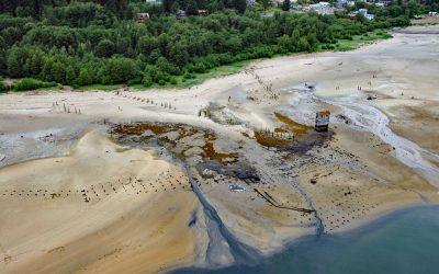
New Carissa, North Spit
New Carissa was a freighter 639 feet (195 m) in length that grounded on North Spit in 1999, causing an oil spill about 5 miles (8 km) northwest of Coos Bay and 4 miles (6.5 km) west of the community of North Bend, Oregon.

Siwash Rock, Stanley Park
Siwash Rock is a sea stack on the western shoreline of Stanley Park in Burrard Inlet, between English Bay to the south and the entrance to Vancouver Harbour to the north, about 3 miles (5 km) northwest of downtown Vancouver, British Columbia.
About the background graphic
This ‘warming stripe’ graphic is a visual representation of the change in global temperature from 1850 (top) to 2019 (bottom). Each stripe represents the average global temperature for one year. The average temperature from 1971-2000 is set as the boundary between blue and red. The colour scale goes from -0.7°C to +0.7°C. The data are from the UK Met Office HadCRUT4.6 dataset.
Click here for more information about the #warmingstripes.