Historical Sites
Recent Articles
More Articles
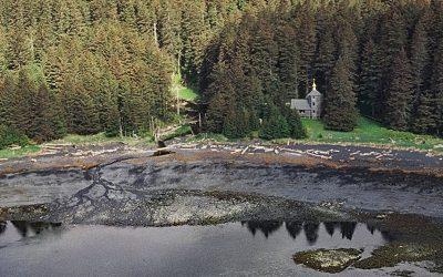
Tyee, Murder Cove
Tyee is the site of a historical cannery and shore whaling station in Murder Cove, an embayment about 0.7 miles (1.2 km) across at the southern tip of Admiralty Island, about 24 miles (39 km) west of Kake and 11 miles (18 km) southeast of Baranof, Alaska.

SS Dominator, Palos Verdes
SS Dominator is a shipwrecked freighter that ran aground in 1961 on the Palos Verdes Peninsula, about 13 miles (21 km) west of Long Beach and 5.6 miles (9 km) south-southwest of Redondo Beach, California.

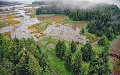
Kukak Cannery, Katmai National Park and Preserve
Kukak Bay is the site of a historical razor clam cannery on the western shore of Shelikof Strait, in Katmai National Park and Preserve, about 132 miles (212 km) southwest of Homer and 77 miles (124 km) northwest of Kodiak, Alaska.

USS Milwaukee, Samoa Beach
The USS Milwaukee was a U.S. Navy cruiser that in 1917 was overcome by wind and waves close to shore and was beached at the community of Samoa on the northern peninsula of Humboldt Bay, about 7 miles (11 km) southwest of Arcata and 1.5 miles (2.4 km) west of Eureka, California.

Gonzales Bay, Victoria
Gonzales Bay is on Vancouver Island and the northern shore of the Strait of Juan de Fuca, situated between Ross Bay to the west and McNeill Bay to the east, and is also the name of a neighborhood about 1.4 miles (2.3 km) southwest of Oak Bay and 2 miles (3.2 km) southeast of downtown Victoria, British Columbia.
Monks Lagoon, Spruce Island
Monks Lagoon is on Icon Bay, a bight about 1 mile (1.6 km) across, on the southeastern shore of Spruce Island, about 6.6 miles (10.6 km) north of Kodiak and 5.7 miles (9 km) south-southeast of Ouzinkie, Alaska.

Bay of Pillars, Kuiu Island
Bay of Pillars is on the west coast of Kuiu Island and 1.5 miles (2.4 km) across between Point Sullivan to the north and Point Ellis to the south, about 52 miles (84 km) southeast of Sitka and 52 miles (84 km) west-southwest of Petersburg, Alaska.
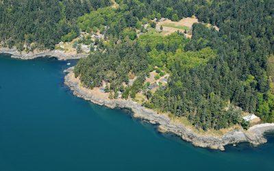
Doe Bay, Orcas Island
Doe Bay is a small community on the southeastern shore of Orcas Island in the San Juan Islands of Puget Sound, about 7 miles (11.3 km) southeast of the community of Eastsound, and 3 miles (4.8 km) northeast of Olga, Washington.
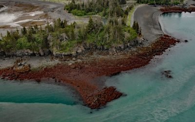
Lancashire Rocks, Kachemak Bay
Lancashire Rocks are a group of offshore rocks and reefs on the western edge of Neptune Bay along the eastern shore of Kachemak Bay, about 13 miles (21 km) northeast of Seldovia and 8 miles (13 km) southeast of Homer, Alaska.
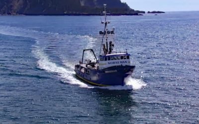
FV Norseman, Princess Royal Channel
The fishing vessel Norseman sank in June 1978 in Princess Royal Channel, approximately 11 miles (18 km) southeast of Butedale and 115 miles (185 km) southeast of Prince Rupert, British Columbia.
About the background graphic
This ‘warming stripe’ graphic is a visual representation of the change in global temperature from 1850 (top) to 2019 (bottom). Each stripe represents the average global temperature for one year. The average temperature from 1971-2000 is set as the boundary between blue and red. The colour scale goes from -0.7°C to +0.7°C. The data are from the UK Met Office HadCRUT4.6 dataset.
Click here for more information about the #warmingstripes.