Islands
Recent Articles
More Articles
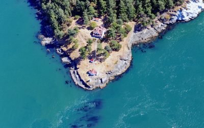
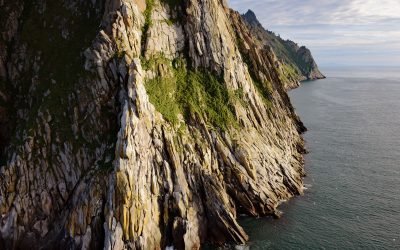
Turn Point, Boundary Pass
Turn Point is a headland with a historic light station on the northwest coast of Stuart Island overlooking Haro Strait to the west and Boundary Pass to the north, located on property that is part of the San Juan Islands National Monument, about 34 miles (55 km) west of Bellingham and 15 miles (24 km) northwest of Friday Harbor, Washington.
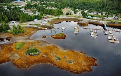
Thorne Bay, Prince of Wales Island
Thorne Bay is a small community, and an estuary of the Thorne River on the eastern coast of Prince of Wales Island, the largest of approximately 1,100 islands interspersed by marine channels in the Alexander Archipelago of Southeast Alaska, about 55 miles (89 km) southwest of Wrangell and 42 miles (68 km) northwest of Ketchikan, Alaska.
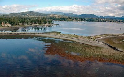
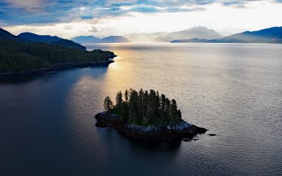
Sooke Harbour, Strait of Juan de Fuca
Sooke is a community on the western shore of Sooke Harbour, a narrow natural embayment separated from the Strait of Juan de Fuca by Whiffin Spit, about 35 miles (56 km) southwest of Port Renfrew and 17 miles (27 km) west-southwest of Victoria, British Columbia.
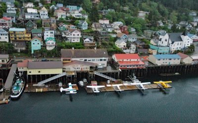
Ketchikan, Revillagigedo Island
Ketchikan is a coastal community and U.S. port of entry on the north shore of Tongass Narrows, on the southern coast of Revillagigedo Island, about 88 miles (142 km) northwest of Prince Rupert and 84 miles (135 km) south-southeast of Wrangell, Alaska.
King Island, Bering Sea
King Island is about 1.7 miles (2.7 km) long and 1.4 miles (2.3 km) wide with steep rocky cliffs on all sides and a summit elevation of about 1,050 feet (320 m), located in the northern Bering Sea, about 86 miles (139 km) northwest of Nome, and 44 miles (71 km) south of Cape Prince of Wales, Alaska.
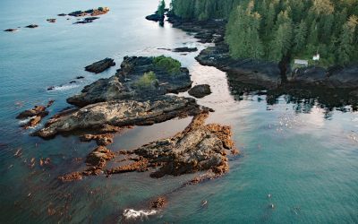
Cerantes Rocks, San Juan Point
Cerantes Rocks is a group of reefs and one large islet situated off of San Juan Point, a rocky headland forming the eastern entrance to Port San Juan on Vancouver Island, about 51 miles (82 km) west-northwest of Victoria and 2.4 miles (4 km) southwest of Port Renfrew, British Columbia.

Big Port Walter, Baranof Island
Port Walter is a fjord 3.7 miles (6 km) long that opens into Chatham Strait on the southeast coast of Baranof Island, about 91 miles (146 km) west of Wrangell and 51 miles (82 km) south-southeast of Sitka, Alaska.
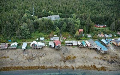
Tenakee Springs, Chichagof Island
Tenakee Springs is a community on the north shore of Tenakee Inlet, on the eastern shore of Chichagof Island in the Alexander Archipelago of Southeast Alaska, about 46 miles (74 km) southwest of Juneau and 30 miles (48 km) northwest of Angoon, Alaska.
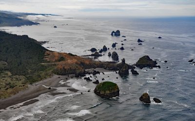
Crook Point, Oregon Islands National Wildlife Refuge
Crook Point is a prominent headland within the Oregon Islands National Wildlife Refuge that includes 1.4 miles (2.3 km) of shoreline with sandy beaches and areas of rocky intertidal, offshore rocks, islets, and subtidal reefs with kelp beds, about 15 miles (24 km) north-northwest of Brookings and 11 miles (18 km) south of Gold Beach, Oregon.
York Island, Wales Passage
York Island is situated at the entrance to Manzanita Cove in Wales Passage, which separates Wales Island from Pearse Island at the head of Dixon Entrance, about 63 miles (101 km) southeast of Ketchikan and 32 miles (51 km) north of Prince Rupert, British Columbia.
About the background graphic
This ‘warming stripe’ graphic is a visual representation of the change in global temperature from 1850 (top) to 2019 (bottom). Each stripe represents the average global temperature for one year. The average temperature from 1971-2000 is set as the boundary between blue and red. The colour scale goes from -0.7°C to +0.7°C. The data are from the UK Met Office HadCRUT4.6 dataset.
Click here for more information about the #warmingstripes.