Islands
Recent Articles
More Articles
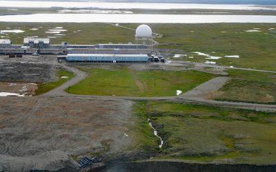
North Warning System, Barter Island
The North Warning System at Barter Island is a long-range radar facility on the Beaufort Sea coast, situated between Arey Lagoon to the west and Kaktovik Lagoon to the east and adjacent to the village of Kaktovik, about 273 miles (440 km) northwest of Inuvik, Northwest Territories, and 112 miles (180 km) east of Deadhorse, Alaska.
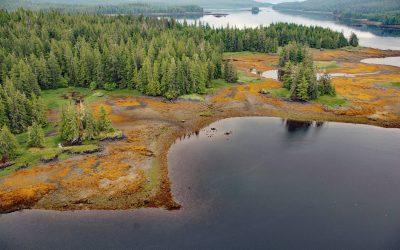
Whale Passage, Prince of Wales Island
Whale Passage is a waterway about 10 miles (16 km) long and the site of a historic logging camp, situated between Thorne Island to the east and Prince of Wales Island to the west, about 40 miles (65 km) southwest of Wrangell and 11 miles (18 km) west-northwest of Coffman Cove, Alaska.
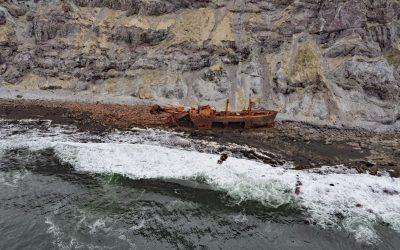
Cape Pankof, Ikatan Peninsula
Cape Pankof is a point of land situated at the eastern tip of the lkatan Peninsula on Unimak Island and the site of the shipwrecked SS Oduna, about 148 miles (239 km) northeast of Dutch Harbor and 18 miles (29 km) southeast of False Pass, Alaska.
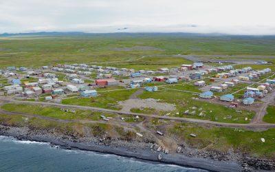
Savoonga, Saint Lawrence Island
Savoonga is a Siberian Yupik community situated on the north flank of the Kookooligit Mountains at Savoonga Point on the north coast of Saint Lawrence Island in the Bering Sea, about 164 miles (265 km) southwest of Nome and 39 miles (63 km) east of Gambell, Alaska.

Año Nuevo Island, Año Nuevo State Park
Año Nuevo Island is the site of a historic light tower and fog signal on about 9 acres (3.6 ha) and separated from Point Año Nuevo by a shallow channel encompassed by Año Nuevo State Park, about 21 miles (34 km) northwest of Santa Cruz and 11 miles (18 km) south-southeast of Pescadero, California.
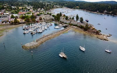
Ganges Harbour, Salt Spring Island
Ganges Harbour is an embayment on the eastern coast of Salt Spring Island that extends 5 miles northwest from Captain Passage, about 35 miles (57 km) southwest of Vancouver, and 15 miles (24 km) north-northwest of Sidney, British Columbia.
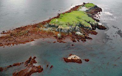
Flat Islands, Kachemak Bay
Flat Islands are situated about 0.8 miles (1.3 km) offshore and 1 mile (1.6 km) north of Point Bede on the Kenai Peninsula along the southern shore of Kachemak Bay in southern Cook Inlet, about 31 miles (50 km) south of Anchor Point and 3 miles (5 km) southwest of Nanwalek, Alaska.
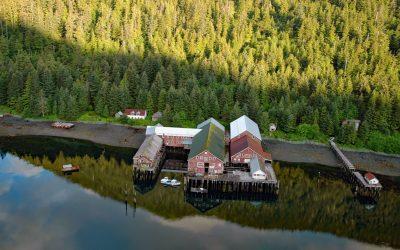
Steamboat Bay, Noyes Island
Steamboat Bay is the site of a historic salmon cannery on the north coast of Noyes Island, part of the Prince of Wales Archipelago in the Gulf of Esquibel of Southeast Alaska, about 122 miles (197 km) southeast of Sitka and 77 miles (124 km) west-northwest of Ketchikan, Alaska.

Five Fingers, Stephens Passage
Five Fingers is a group of islets and the site of a historic lighthouse situated at the southern entrance to Stephens Passage, about 67 miles (108 km) east-northeast of Sitka and 41 miles (66 km) northwest of Petersburg, Alaska.
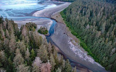
Roller Bay, Noyes Island
Roller Bay is located on the west coast of Noyes Island near a prehistoric rock shelter on Cape Addington to the south, and Cape Ulitka to the north, about 122 miles (196 km) southeast of Sitka and 24 miles (39 km) west of Craig, Alaska.
About the background graphic
This ‘warming stripe’ graphic is a visual representation of the change in global temperature from 1850 (top) to 2019 (bottom). Each stripe represents the average global temperature for one year. The average temperature from 1971-2000 is set as the boundary between blue and red. The colour scale goes from -0.7°C to +0.7°C. The data are from the UK Met Office HadCRUT4.6 dataset.
Click here for more information about the #warmingstripes.