Islands
Recent Articles
More Articles
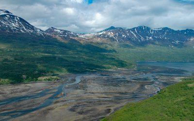
Terror Bay, Kodiak National Wildlife Refuge
Terror Bay is on the northern coast of Kodiak Island and extends about 7 miles (11 km) south from Uganik Passage to the mouth of Terror River in Kodiak National Wildlife Refuge, about 32 miles (52 km) east-northeast of Larsen Bay and 30 miles (48 km) west-southwest of Kodiak, Alaska.

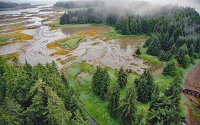
Elfin Cove, Chichagof Island
Elfin Cove is an embayment that extends south from Cross Sound for 1 mile (1.6 km) and narrows to just over 100 feet (30 m) on the western shore of the Inian Peninsula at the northern end of Chichagof Island in Tongass National Forest, about 80 miles (129 km) west of Juneau and 34 miles (55 km) northwest of Hoonah, Alaska.
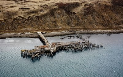
Mutton Cove, Chernofski Harbor
Mutton Cove is an embayment on Unalaska Island about 0.3 miles (0.5 km) across situated on the northern shore of Chernofski Harbor and protected by Observatory Point to the west, about 64 miles (103 km) northeast of Nikolski and 53 miles (85 km) southwest of Dutch Harbor, Alaska.

Lime Kiln Lighthouse, San Juan Island
Lime Kiln Light was established in 1919 on Lime Kiln Point, a day-use park of 36 acres (15 ha) overlooking Deadman Bay to the south and Haro Strait to the west on the west coast of San Juan Island, about 12 miles (19 km) northeast of Victoria and 6.4 miles (10 km) west-southwest of Friday Harbor, Washington.

Staines Point, Trial Islands
Staines Point is the southern tip of the Trial Islands which comprise two islets separated by a narrow channel situated in the Strait of Juan de Fuca about 0.5 miles (0.8 km) offshore from the southern end of Vancouver Island at McNeill Bay, about 3.5 miles (5.6 km) southeast of Victoria and 2 miles (3.2 km) south-southeast of Oak Bay, British Columbia.

SS Yukon, Sanak Island
The steamship Yukon, bound from Goodnews Bay on the Kuskokwim River to Seattle in 1913, ran aground in fog and became a total loss on the northwest end of Sanak Island on what is now called Yukon Reef, about 156 miles (252 km) east-northeast of Dutch Harbor and 48 miles (77 km) south-southwest of King Cove, Alaska.

Point Elrington, Elrington Island
Point Elrington is a tied island connected by a gravel isthmus to the southwestern tip of Elrington Island in the Gulf of Alaska, about 96 miles (155 km) southwest of Cordova and 43 miles (69 km) east-southeast of Seward, Alaska.
Treadwell Mine, Douglas Island
Treadwell is a historical gold mine on the eastern coast of Douglas Island on Gastineau Channel, about 1.2 miles (1.9 km) southeast of the community of Douglas and 3 miles (4.8 km) southeast of Juneau, Alaska.
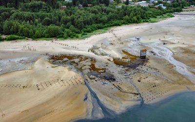
Tyee, Murder Cove
Tyee is the site of a historical cannery and shore whaling station in Murder Cove, an embayment about 0.7 miles (1.2 km) across at the southern tip of Admiralty Island, about 24 miles (39 km) west of Kake and 11 miles (18 km) southeast of Baranof, Alaska.
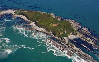
Destruction Island, Quillayute Needles National Wildlife Refuge
Destruction Island is part of the Quillayute Needles National Wildlife Refuge, located 3.5 miles (6 km) offshore from the Olympic Peninsula, about 56 miles (90 km) southwest of Port Angeles and 17 miles (27 km) south-southeast of La Push, Washington.
About the background graphic
This ‘warming stripe’ graphic is a visual representation of the change in global temperature from 1850 (top) to 2019 (bottom). Each stripe represents the average global temperature for one year. The average temperature from 1971-2000 is set as the boundary between blue and red. The colour scale goes from -0.7°C to +0.7°C. The data are from the UK Met Office HadCRUT4.6 dataset.
Click here for more information about the #warmingstripes.