
LAST MONTH

Peter Iredale, Clatsop Spit
Peter Iredale was a British four-masted bark-rigged sailing ship with a length of 275 feet (84 m) that ran aground in 1906 and wrecked on Clatsop Spit, about 7 miles (11 km) west of Astoria and 2 miles ( km) southwest of Hammond, Oregon.
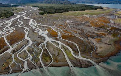
Grewingk Creek, Kachemak Bay
Grewingk Creek drains a glaciated watershed of 29,138 acres (11,792 ha) and flows generally northwest for 3.5 miles (5.6 km) from the terminus lake of the retreating Grewingk Glacier to the southeastern shore of Kachemak Bay, about 24 miles (39 km) northeast of Seldovia and 13 miles (21 km) east of Homer, Alaska.
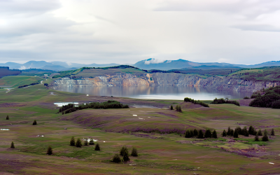
Island Copper Mine, Rupert Inlet
Island Copper was an open pit mine located at the northern end of Vancouver Island on Rupert Inlet at the head of Quatsino Sound, about 4.6 miles (7.4 km) east of Coal Harbour and 8.5 miles (14 km) south of Port Hardy, British Columbia.
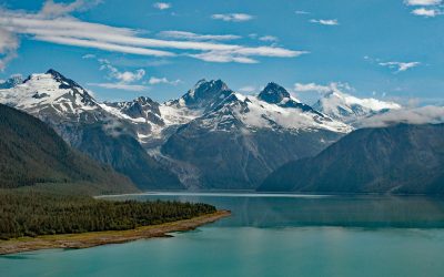
Lituya Bay, Glacier Bay National Park and Preserve
Lituya Bay is a fjord located in Glacier Bay National Park and Preserve on the outer coast of Southeast Alaska, about 97 miles (156 km) southeast of Yakutat and 70 miles (113 km) west-northwest of Gustavus, Alaska.
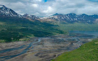
Terror Bay, Kodiak National Wildlife Refuge
Terror Bay is on the northern coast of Kodiak Island and extends about 7 miles (11 km) south from Uganik Passage to the mouth of Terror River in Kodiak National Wildlife Refuge, about 32 miles (52 km) east-northeast of Larsen Bay and 30 miles (48 km) west-southwest of Kodiak, Alaska.

Tennessee Cove, Golden Gate National Recreation Area
Tennessee Cove is an embayment with a sandy beach about 600 feet (180 m) long on the Pacific Ocean between Pirates Cove to the north and Rodeo Cove to the south in Golden Gate National Recreation Area about 10 miles (16 km) northwest of San Francisco and 3.6 miles (5.8 km) southwest of Mill Valley, California.

Elfin Cove, Chichagof Island
Elfin Cove is an embayment that extends south from Cross Sound for 1 mile (1.6 km) and narrows to just over 100 feet (30 m) on the western shore of the Inian Peninsula at the northern end of Chichagof Island in Tongass National Forest, about 80 miles (129 km) west of Juneau and 34 miles (55 km) northwest of Hoonah, Alaska.
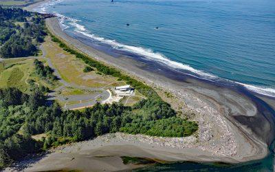
Winchuk River, Crissey Field
Winchuck River starts at an elevation of about 2,000 feet (610 m) and flows generally southwest for 19 miles (31 km) through the Rogue River–Siskiyou National Forest to the Pacific Ocean at Crissey Field, about 17 miles (27 km) north of Crescent City and 4.8 miles (7.7 km) southeast of Brookings, Oregon.

Dangerous Cape, Port Graham
Dangerous Cape is a headland with an elevation of 66 feet (20 m) on the southern Kenai Peninsula, at the northern entrance of Port Graham near the mouth of Kachemak Bay, about 22 miles (35 km) southwest of Homer and 4 miles (6.5 km) northwest of the community of Port Graham, Alaska.

Pachena Point Lighthouse, Pacific Rim National Park Reserve
Pachena Point Light Station is located on the west coast of Vancouver Island in Pacific Rim National Park Reserve, about 82 miles (132 km) northwest of Victoria and 8 miles (13 km) south-southeast of Bamfield, British Columbia.
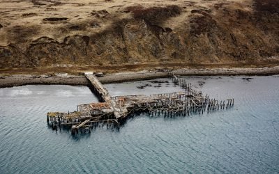
Mutton Cove, Chernofski Harbor
Mutton Cove is an embayment on Unalaska Island about 0.3 miles (0.5 km) across situated on the northern shore of Chernofski Harbor and protected by Observatory Point to the west, about 64 miles (103 km) northeast of Nikolski and 53 miles (85 km) southwest of Dutch Harbor, Alaska.
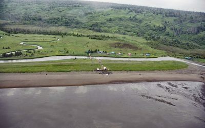
Polly Creek, Cook Inlet
Polly Creek and Little Polly Creek drain a combined watershed of 16,113 acres (6,521 ha), on the southern flank of an unnamed ridge that extends southeast from the summit of Mount Redoubt, and flow generally south for 9 miles (14.5 km) and 8 miles (12.8 km) respectively to the western shore of Cook Inlet, about 56 miles (90 km) northwest of Homer and 46 miles (74 km) southwest of Kenai, Alaska.