Rivers
Recent Articles
More Articles
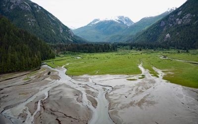
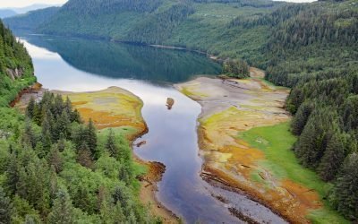
Kowesas River, Chief Mathews Bay
Kowesas River flows generally north for 22 miles (35 km), draining a watershed of 101,807 acres (41,200 ha) in the Coast Mountains before emptying into the head of Chief Mathews Bay, about 112 miles (180 km) southeast of Prince Rupert and 17 miles (27 km) south-southwest of Kemano, British Columbia.

McNeil Canyon, Kachemak Bay
McNeil Canyon is on the Kenai Peninsula and the northern shore of Kachemak Bay and trends south for about 2 miles (3.2 km) following the lower course of McNeil Creek, about 57 miles (92 km) south of Kenai and 12 miles (19 km) northeast of Homer, Alaska.
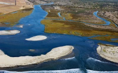
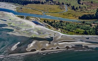
Tijuana River, Imperial Beach
Tijuana River drains a 1.1‑million‑acre (450,000 ha) watershed that originates in the Sierra de Juárez in northern Baja California and flows west‑northwest for 120 miles to the Pacific at the southern edge of Imperial Beach, about 11 miles south of San Diego and 5 miles northwest of Tijuana, Mexico.
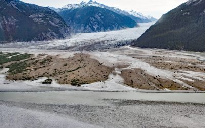
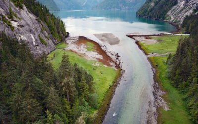
Baird Glacier, Thomas Bay
Baird Glacier starts in the Stikine Icefield in the Boundary Ranges of the Coast Mountains near the Alaska-British Columbia border, and flows generally southwest for 24 miles (39 km) to its terminus at an outwash plain 2 miles (3.2 km) north of the head of Thomas Bay, about 100 miles (162 km) southeast of Juneau and 22 miles (35 km) north-northeast of Petersburg, Alaska.
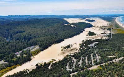
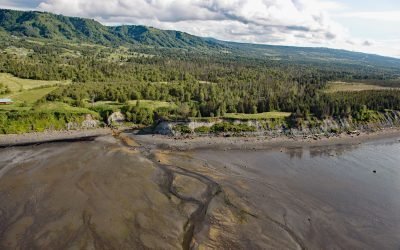
Umpqua River, Winchester Bay
Umpqua River flows generally west-northwest for 111 miles (179 km), draining a watershed of 2.4 million acres (1 million ha), from the Cascade Mountains through the Coast Range to Winchester Bay in the Oregon Dunes, about 20 miles (32 km) north of Coos Bay and 5.5 miles (9 km) southwest of Reedsport, Oregon.
Triumph Bay, Gardner Canal
Triumph Bay is a long narrow embayment located on the south side of Alan Reach in Gardner Canal, British Columbia.
Pysht River, Pillar Point
Pysht River originates near Ellis Mountain on the Olympic Peninsula and flows generally northeast for 16 miles (26 km), draining a watershed of 29,632 acres (11,992 ha), to the Strait of Juan de Fuca at Pillar Point, about 31 miles (50 km) west-northwest of Port Angeles and 26 miles (42 km) southeast of Neah Bay, Washington.
Brim River Hot Springs, Gardner Canal
Brim River Hot Springs and adjoining Owyacumish River Park protect 2,488 acres (1,007 ha) at the head of Owyacumish Bay on the north shore of Gardner Canal, about 96 miles (155 km) southwest of Prince Rupert and 40 miles (64 km) south-southwest of Kitimat, British Columbia.
Fritz Creek, Kachemak Bay
Fritz Creek is a stream on the Kenai Peninsula that starts from a watershed divide between Lookout Mountain to the south and Bald Mountain to the north and flows generally south for 7 miles (11 km) to the north shore of Kachemak Bay, about 17 miles (27 km) southeast of Anchor Point and 6 miles (10 km) northeast of Homer, Alaska.
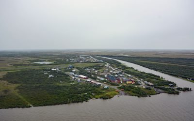
Napakiak, Kuskokwim River
Napakiak is a village located on an island situated between the Kuskokwim River to the south and Johnson Slough to the north, about 167 miles (269 km) southeast of Emmonak and 10 miles (16 km) southwest of Bethel, Alaska.
About the background graphic
This ‘warming stripe’ graphic is a visual representation of the change in global temperature from 1850 (top) to 2019 (bottom). Each stripe represents the average global temperature for one year. The average temperature from 1971-2000 is set as the boundary between blue and red. The colour scale goes from -0.7°C to +0.7°C. The data are from the UK Met Office HadCRUT4.6 dataset.
Click here for more information about the #warmingstripes.