
Alaska
Recent Articles
More Articles
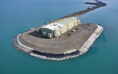
West Dock Causeway, Prudhoe Bay
West Dock Causeway was constructed in the Beaufort Sea between Gwydyr Bay to the west and Prudhoe Bay to the east in support of oil exploration and to access a seawater treatment facility 2.5 miles (4.3 km) north from the mainland, about 59 miles (95 km) northeast of Nuiqsut and 15 miles (24 km) north of Deadhorse, Alaska.

Guyot Glacier, Icy Bay
Guyot Glacier starts from an elevation of about 6,700 feet (2,042 m) on the eastern flank of Yaga Peak in the Robinson Mountains and flows generally east-southeast for 34 miles (55 km) to its terminus just south of the Guyot Hills on the western shore of Icy Bay in Wrangell-Saint Elias National Park and Preserve, about 146 miles (235 km) east-southeast of Cordova and 76 miles (123 km) northwest of Yakutat, Alaska.

Sumdum Glacier, Powers Creek
Sumdum Glacier starts on the south flank of Mount Sumdum with a summit elevation of 6,666 feet (2,032 m) and flows southwest to a hanging terminus at 2,100 feet (640 m) and the start of Powers Creek that flows 2 miles (3.2 km) to the eastern shore of Endicott Arm, about 89 miles (144 km) northeast of Sitka and 50 miles (81 km) southeast of Juneau, Alaska.
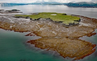
Nordyke Island, Kamishak Bay
Nordyke Island is about 35 feet (11 m) high, flat topped and grass covered, and located in Kamishak Bay, about 115 miles (186 km) northwest of Kodiak and 96 miles (155 km) southwest of Homer, Alaska.
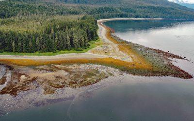
Sumdum, Endicott Arm
Sumdum is a historical Tlingit village of the S’awdaan Kwáan located north of Powers Creek at the northern end of Endicott Arm where it meets Holkham Bay in Tracy Arm-Fords Terror Wilderness, about 70 miles (113 km) north-northwest of Petersburg and 49 miles (79 km) southeast of Juneau, Alaska.
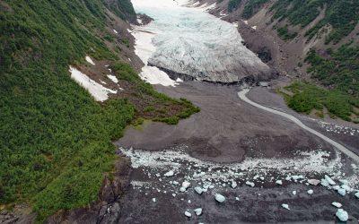
Tigertail Glacier, Nassau Fjord
Tigertail Glacier starts at an elevation of about 2,850 feet (869 m) in the Sargent Icefield on the Kenai Peninsula and flows generally northeast for 3.3 miles (5.3 km) and terminates 0.2 miles (0.3 km) from the western shore of Nassau Fjord, which is a northern arm of Icy Bay in western Prince William Sound, about 36 miles (58 km) east-northeast of Seward and 36 miles (58 km) south-southeast of Whittier, Alaska.

Main Bay, Prince William Sound
Main Bay is an estuary on the Kenai Peninsula fed by a watershed of 3,795 acres (1,536 ha) mostly draining from an unnamed lake at an elevation of 205 feet (62 m) on the northern flank of Eshamy Peak in Prince William Sound, between Port Nellie Juan to the west and Knight Island Passage to the east, about 81 miles (131 km) west of Cordova and 28 miles (45 km) southeast of Whittier, Alaska.
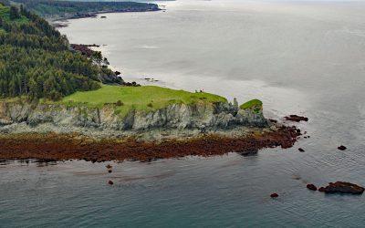
Point Pogibshi, Kachemak Bay
Point Pogibshi is a prominent flat-topped grassy headland with rocky sides about 50 feet (15 m) high on the southern shore of Kachemak Bay, about 20 miles (23 km) southwest of Homer, and 5 miles (8 km) north-northeast of Nanwalek, Alaska.
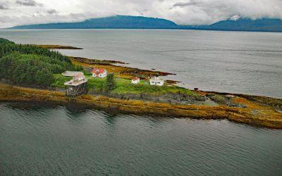
Point Retreat, Admiralty Island
Point Retreat is a headland with a historic lighthouse on the Mansfield Peninsula at the northern tip of Admiralty Island, between Lynn Canal to the west and Saginaw Channel of Stephens Passage to the east, about 60 miles (97 km) south-southeast of Haines and 20 miles (32 km) northwest of Juneau, Alaska.
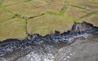
Drew Point, Smith Bay
Drew Point is located at the eastern entrance to Smith Bay on the Beaufort Sea and is formed by rapidly eroding permafrost and ice wedges at the edge of the Arctic Coastal Plain, about 81 miles (131 km) northwest of Nuiqsut and 70 miles (113 km) southeast of Utqiaġvik, Alaska.
About the background graphic
This ‘warming stripe’ graphic is a visual representation of the change in global temperature from 1850 (top) to 2019 (bottom). Each stripe represents the average global temperature for one year. The average temperature from 1971-2000 is set as the boundary between blue and red. The colour scale goes from -0.7°C to +0.7°C. The data are from the UK Met Office HadCRUT4.6 dataset.
Click here for more information about the #warmingstripes.