Beaches
Recent Articles
More Articles

Mad River, McKinleyville
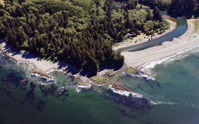
Mad River starts in the Coast Range at an elevation of 4,845 ft (1,477 m) and flows generally northwest for 113 miles (182 km), draining a watershed of 318,080 acres (128,722 ha), and enters the Pacific Ocean about 12 miles (19 km) north of Eureka and 1.8 miles (3 km) northwest of McKinleyville, California.

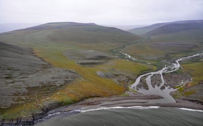
Point Barrow, Elson Lagoon
Point Barrow is a spit that extends northeast from the mainland for 4 miles (6.4 km) into the Arctic Ocean forming Elson Lagoon to the southeast, about 150 miles (242 km) northwest of Nuiqsut and 9.8 miles (16 km) northeast of Utqiaġvik, Alaska.

Point Robinson, Maury Island
Point Robinson is the eastern point of Maury Island in Puget Sound and the site of a historic lighthouse, about 15 miles (24 km) south of Seattle and 10 miles (16 km) north-northeast of Tacoma, Washington.

Ivanof Bay, Alaska Peninsula
Ivanof Bay is a community on the Alaska Peninsula at the head of Ivanof Bay, an estuary of the Ivanof River that starts at an elevation of roughly 1000 feet (305 m) on the south flank of the Alaska Peninsula and flows generally southwest for 9 miles (15 km) draining a watershed of 15,545 acres (6,291 ha), about 57 miles (92 km) northeast of Sand Point and 13 miles (21 km) west of Perryville, Alaska.
Hoko River, Kydaka Point
Hoko River starts in the foothills of the Olympic Mountains at an elevation of roughly 1150 feet (351 m) and flows generally north for 25 miles (40 km), draining a rugged heavily logged watershed of 48,000 acres (19,425 ha) to Kydaka Point on the Strait of Juan de Fuca, about 13 miles (21 km) southeast of Neah Bay and 3.3 miles (5 km) northwest of Sekiu, Washington.
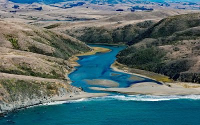
Estero Americano, Bodega Bay
Estero Americano is an estuary about 4 miles (6.5 km) long that connects to Bodega Bay and is fed by Americano Creek that starts at an elevation of roughly 250 feet (76 m) in the coastal hills of Sonoma and Marin Counties and flows west for 11 miles (18 km) draining a watershed of 24,277 acres (9,825 ha), about 19 miles (31 km) southwest of Santa Rosa and 3.7 miles (6 km) northwest of Dillion Beach, California.
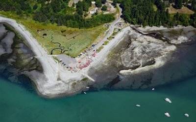
Little Boston, Point Julia
Little Boston is a community at the base of Point Julia on the east side entrance of Port Gamble, an inlet on the Kitsap Peninsula near the entrance to Hood Canal, about 21 miles (34 km) northwest of Seattle and 20 miles (32 km) southeast of Port Townsend, Washington.
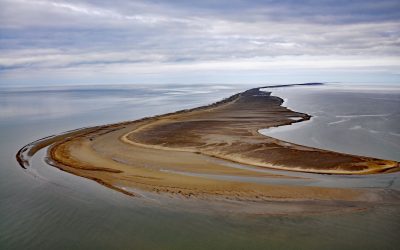
Solivik Island, Utukok Pass
Solivik Island is an Arctic barrier island that extends southwest for 16.5 miles (27 km) from Icy Cape Pass in the north to Utukok Pass in the south and forms the northern portion of Kasegaluk Lagoon, about 69 miles (111 km) southwest of Wainwright and 28 miles (45 km) north-northeast of Point Lay, Alaska.
Kapaloak Creek, Cape Dyer
Kapaloak Creek starts from an elevation of roughly 1200 feet (366 m) in the Lisburne Hills and flows generally west for 8.5 miles (14 km) to Cape Dyer on the Chukchi Sea and the site of a historical Iñupiat village, about 110 miles (177 km) southwest of Point Lay and 25 miles (40 km) north-northeast of Point Hope, Alaska.
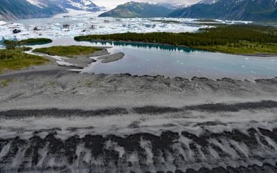
Bear Glacier, Aialik Peninsula
Bear Glacier starts from an elevation of roughly 4,000 feet (1,219 m) on the eastern flank of the Harding Icefield in Kenai Fjords National Park and descends generally southeast for 17 miles (27 km) to a proglacial lake dammed by a terminal moraine between Bear Glacier Point on the Aialik Peninsula to the south and Callisto Head to the north, about 72 miles (116 km) east-northeast of Homer and 13 miles (21 km) south of Seward, Alaska.
About the background graphic
This ‘warming stripe’ graphic is a visual representation of the change in global temperature from 1850 (top) to 2019 (bottom). Each stripe represents the average global temperature for one year. The average temperature from 1971-2000 is set as the boundary between blue and red. The colour scale goes from -0.7°C to +0.7°C. The data are from the UK Met Office HadCRUT4.6 dataset.
Click here for more information about the #warmingstripes.