Beaches
Recent Articles
More Articles
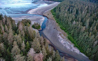
Roller Bay, Noyes Island
Roller Bay is located on the west coast of Noyes Island near a prehistoric rock shelter on Cape Addington to the south, and Cape Ulitka to the north, about 122 miles (196 km) southeast of Sitka and 24 miles (39 km) west of Craig, Alaska.
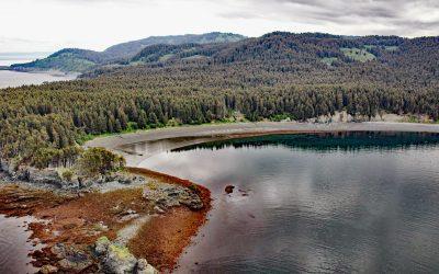
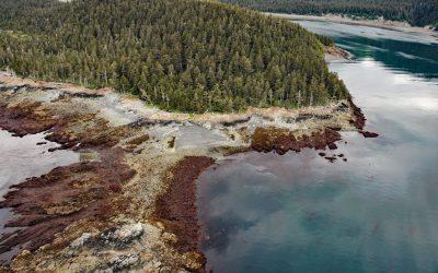
Coal Cove, Port Graham
Coal Cove is the site of a historic Russian coal mine at Dangerous Cape on the north shore entrance to Port Graham near the southern end of the Kenai Peninsula, about 7 miles (11 km) southwest of Seldovia and 3 miles (5 km) north-northeast of Nanwalek, Alaska.
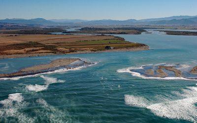
Eel River Delta, Eel River
A delta of 33,000 acres (13,355 ha) is formed by the Eel River, which starts at an elevation of 6,245 feet (1,903 m) on the southern flank of Bald Mountain in Mendocino National Forest and flows generally northwest for 196 miles (315 km) draining a watershed of 2,357,761 acres (954,152 ha) in the California Coast Ranges, about 13 miles (21 km) south-southwest of Eureka and 5 miles (8 km) northwest of Ferndale, California.
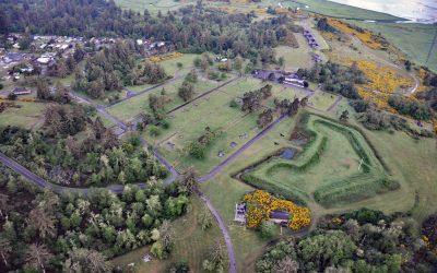
Fort Stevens, Point Adams
Fort Stevens was constructed during the American Civil War as an earthwork battery on the south shore at the mouth of the Columbia River on Point Adams, about 15 miles (24 km) north of Seaside and 6 miles (10 km) west-northwest of Astoria, Oregon.
Claim Point, Chrome Bay
Claim Point forms the western shore of Chrome Bay at the northern entrance to Port Chatham on the Kenai Peninsula, the site of a historical chromite mine, about 100 miles (162 km) north-northwest of Kodiak and 33 miles (53 km) south-southwest of Homer, Alaska.
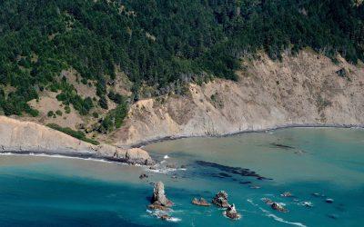
Cluster Cone Rocks, Bear Harbor
Cluster Cone Rocks are at Bear Harbor, the site of a historical lumber wharf built over the rocky point that protects a small south-facing embayment with a sandy beach in Sinkyone Wilderness State Park on the Mendocino coast, about 21 miles (34 km) north-northwest of Westport and 12 miles (19 km) west-northwest of Leggett, California.
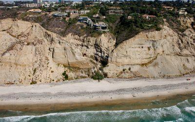
Black’s Beach, Torrey Pines
Black’s Beach is the secluded southern section of Torrey Pines State Beach, which starts at the mouth of Los Peñasquitos Lagoon to the north and extends south for about 4.5 miles (7.2 km) to Scripps Beach, about 10 miles (16 km) south of Encinitas and 4 miles (6.5 km) north-northeast of La Jolla, California.
Lily Point, Boundary Bay
Lily Point Marine Reserve is a park located on Boundary Bay at the southeastern tip of Point Roberts, an exclave of the United States on the southern coast of the Tsawwassen Peninsula, about 22 miles (35 km) south-southeast of Vancouver and 30 miles (48 km) northwest of Bellingham, Washington.
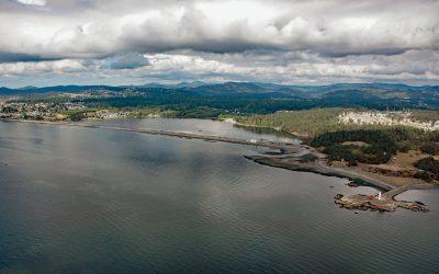
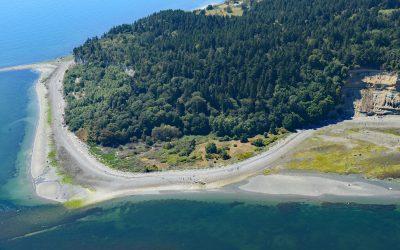
Esquimalt Lagoon, Royal Roads
Esquimalt Lagoon is formed by the Coburg Peninsula, a sand and gravel barrier spit 1.2 miles (1.9 km) long at Royal Roads on Vancouver Island, about 4.4 miles (7.3 km) west of Victoria in the city of Colwood, British Columbia.
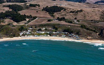
Martins Beach, Half Moon Bay
Martins Beach is a public beach adjacent to a private gated community protected from erosion by a seawall, about 6 miles (10 km) south of the community of Half Moon Bay and 0.7 miles (1.1 km) southwest of Lobitos, California.
About the background graphic
This ‘warming stripe’ graphic is a visual representation of the change in global temperature from 1850 (top) to 2019 (bottom). Each stripe represents the average global temperature for one year. The average temperature from 1971-2000 is set as the boundary between blue and red. The colour scale goes from -0.7°C to +0.7°C. The data are from the UK Met Office HadCRUT4.6 dataset.
Click here for more information about the #warmingstripes.