
California
Recent Articles
More Articles

Stinson Beach, Bolinas Bay
Stinson Beach is a community on Bolinas Bay developed on a crescent-shaped sand spit partially enclosing Bolinas Lagoon between Duxbury Point to the northwest and Rocky Point to the south, about 15 miles (24 km) northwest of San Francisco and 14 miles (23 km) south-southeast of Point Reyes Station, California.

Mad River, McKinleyville
Mad River starts in the Coast Range at an elevation of 4,845 ft (1,477 m) and flows generally northwest for 113 miles (182 km), draining a watershed of 318,080 acres (128,722 ha), and enters the Pacific Ocean about 12 miles (19 km) north of Eureka and 1.8 miles (3 km) northwest of McKinleyville, California.

Devil’s Punchbowl, Russian Gulch State Park
Devil’s Punchbowl is a sinkhole formed by a collapsed sea cave over 70 feet (21 m) deep and 100 feet (30 m) in diameter near the mouth of Russian Gulch Creek in Russian Gulch State Park, about 8 miles (13 km) south of Fort Bragg and 1.6 miles (2.6 km) north-northwest of Mendocino, California.

Pitkins Curve Bridge and Rock Shed, Big Sur
Pitkins Curve Bridge and Rock Shed are currently one of the most active landslide sites on the Big Sur Coast Highway situated just north of Limekiln State Park, about 45 miles (73 km) southeast of Monterey and 1.5 miles (2.4 km) south of Lucia, California.
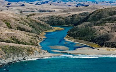
Estero Americano, Bodega Bay
Estero Americano is an estuary about 4 miles (6.5 km) long that connects to Bodega Bay and is fed by Americano Creek that starts at an elevation of roughly 250 feet (76 m) in the coastal hills of Sonoma and Marin Counties and flows west for 11 miles (18 km) draining a watershed of 24,277 acres (9,825 ha), about 19 miles (31 km) southwest of Santa Rosa and 3.7 miles (6 km) northwest of Dillion Beach, California.
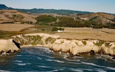
KFS High-Frequency Receiver, Half Moon Bay
KFS WebSDR is co-located with the KFS Kiwi high-frequency radio receiver station near the mouth of Lobitos Creek, about 5.5 miles (9 km) south of Half Moon Bay and 0.8 miles (1.3 km) west of Lobitos, California.
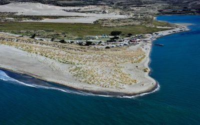
Lawson’s Landing, Sand Point
Lawson’s Landing is a recreational area and campground on 75 acres (30 ha) in the Tomales Dunes Complex on Tomales Bay at Sand Point, about 20 miles (32 km) southwest of Santa Rosa and 1 mile (1.6 km) south of Dillion Beach, California.

Fort Miley, Lands End
The Marine Exchange Lookout Station is on Fort Miley at Lands End in the Golden Gate National Recreation Area, about 6 miles (10 km) west of downtown San Francisco and 2.7 miles (4.4 km) southwest of the Presidio at the Golden Gate, California.
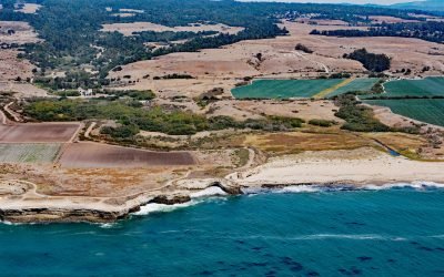
Wilder Ranch State Park, Natural Bridges State Marine Reserve
Wilder Ranch is a California State Park bordered by the Natural Bridges State Marine Reserve, located about 59 miles (95 km) south-southeast of San Francisco and 3 miles (5 km) southwest of Santa Cruz, California.
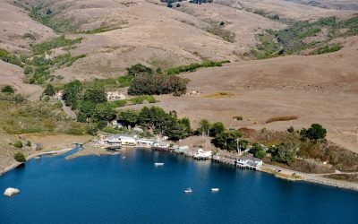
Marshall, Tomales Bay
Marshall is on the northeast shore of Tomales Bay, about 15 miles (24 km) southeast of Bodega Bay and 6 miles (9.7 km) south of Tomales, California.
About the background graphic
This ‘warming stripe’ graphic is a visual representation of the change in global temperature from 1850 (top) to 2019 (bottom). Each stripe represents the average global temperature for one year. The average temperature from 1971-2000 is set as the boundary between blue and red. The colour scale goes from -0.7°C to +0.7°C. The data are from the UK Met Office HadCRUT4.6 dataset.
Click here for more information about the #warmingstripes.