
Climate Change
Recent Articles
More Articles
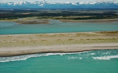
Situk River, Johnson Slough
Situk River starts at Situk Lake and flows southwest for about 18 miles (29 km) through the Yakutat Forelands in Tongass National Forest to Johnson Slough on the Gulf of Alaska, about 200 miles (322 km) northwest of Juneau and 9 miles (15 km) southeast of Yakutat, Alaska.
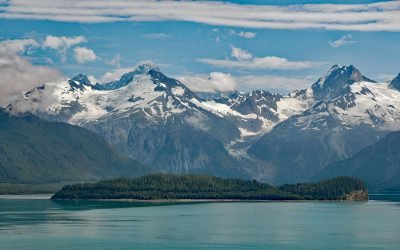
Cenotaph Island, Lituya Bay
Cenotaph Island is approximately in the middle of Lituya Bay, a fjord formed primarily by the Crillon and Lituya glaciers in Glacier Bay National Park and Preserve, about 117 miles (189 km) west-northwest of Juneau and 97 miles (156 km) southeast of Yakutat, Alaska.

Mendenhall Glacier, Juneau Icefield
Mendenhall Glacier starts from an ice divide in the Juneau Icefield at an elevation of 4,300 feet (1,311 m) and flows generally southwest for 15 miles (24 km) to a proglacial lake between McGinnis Mountain to the west and Bullard Mountain to the east, about 11 miles (18 km) north-northwest of Juneau and 5 miles (8 km) northeast of Auke Bay, Alaska.

North Crillon Glacier, Lituya Bay
North Crillon Glacier starts from a cirque at an elevation near 6,200 feet (1,890 m) on the west flank of Mount Crillon in the Fairweather Range, and flows generally southwest for 9 miles (15 km) and then makes an abrupt turn to the north and continues for another 3 miles (5 km) to the head of Lituya Bay, about 100 miles (161 km) southeast of Yakutat and 65 miles (105 km) west-northwest of Gustavus, Alaska.

Cascade Glacier, Lituya Bay
Cascade Glacier starts from the western slope of Peak 7788 (2,374 m) in the Fairweather Range and flows generally west for 2.6 miles (4 km) to the head of Lituya Bay in Glacier Bay National Park and Preserve, about 97 miles (156 km) southeast of Yakutat and 67 miles (108 km) northwest of Gustavus, Alaska.

Lawrence Glacier, Blackstone Bay
Lawrence Glacier starts from several cirques situated at the northern extent of the Kenai Mountains at an elevation of roughly 3,000 feet (915 m) and flows generally northwest for 2.4 miles (4 km) to within a few hundred feet of tidewater at the south end of Willard Island in Blackstone Bay, about 84 miles (135 km) west-southwest of Valdez and 7 miles (11 km) south-southeast of Whittier, Alaska.

Pedersen Lagoon, Aialik Bay
Pedersen Lagoon receives freshwater from proglacial lakes of the Addison and Pedersen glaciers that descend from the Harding Icefield in Kenai Fjords National Park on the western shore of Aialik Bay, about 64 miles (103 km) east-northeast of Homer and 19 miles (31 km) south-southwest of Seward, Alaska.

Bodfish Island, Simpson Lagoon
Bodfish Island is part of the Jones Island barrier chain between Cottle Island to the east and Bertoncini Island to the west, separating Simpson Lagoon from the Beaufort Sea, about 178 miles (286 km) southeast of Utqiagvik and 30 miles (48 km) northwest of Deadhorse, Alaska.

Shoup Glacier, Port Valdez
Shoup Glacier starts at an elevation of roughly 6,800 feet (2,073 m) in the Chugach Mountains between Mount Shouplina to the west and Mount Logan to the east, and flows 16 miles (26 km) generally south-southwest to Shoup Bay on the northwest shore of Port Valdez in Prince William Sound, about 74 miles (119 km) east-northeast of Whittier and 9 miles (15 km) west of Valdez, Alaska.

Toke Point, Willapa Bay
Toke Point is at the end of Tokeland Spit that projects southeast for 3 miles (5 km) from the northern shore of Willapa Bay, a large estuary formed by several streams, the largest being Willapa River, about 55 miles (89 km) southwest of Olympia and 15 miles (24 km) south-southeast of Westport, Washington.
About the background graphic
This ‘warming stripe’ graphic is a visual representation of the change in global temperature from 1850 (top) to 2019 (bottom). Each stripe represents the average global temperature for one year. The average temperature from 1971-2000 is set as the boundary between blue and red. The colour scale goes from -0.7°C to +0.7°C. The data are from the UK Met Office HadCRUT4.6 dataset.
Click here for more information about the #warmingstripes.