
Glaciers
Recent Articles
More Articles

McBride Glacier, Muir Inlet
McBride Glacier starts from a series of cirques at elevations near 5500 feet (1676 m) on the southern flank of the Takhinsha Mountains in Glacier Bay National Park and Preserve and flows generally south for roughly 10 miles (16 km) to McBride Inlet which connects to Muir Inlet, about 46 miles (74 km) north-northwest of Gustavus and 25 miles (40 km) southwest of Haines, Alaska.

Bering River, Controller Bay
Bering River starts from a series of ice-marginal lakes and streams draining from the Martin River, Steller, and Bering glaciers, and flows generally south-southwest for 18 miles ( km) to Controller Bay on the Gulf of Alaska, about 63 miles (102 km) west of Cape Yakutaga and 58 miles (94 km) southeast of Cordova, Alaska.
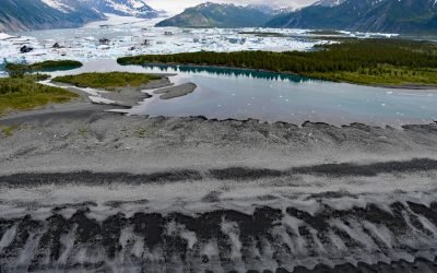
Bear Glacier, Aialik Peninsula
Bear Glacier starts from an elevation of roughly 4,000 feet (1,219 m) on the eastern flank of the Harding Icefield in Kenai Fjords National Park and descends generally southeast for 17 miles (27 km) to a proglacial lake dammed by a terminal moraine between Bear Glacier Point on the Aialik Peninsula to the south and Callisto Head to the north, about 72 miles (116 km) east-northeast of Homer and 13 miles (21 km) south of Seward, Alaska.

Margerie Glacier, Tarr Inlet
Margerie Glacier starts at an elevation of 9,860 feet (3,005 m) on the international border of the United States and Canada between Mount Root to the north and Mount Fairweather to the south and flows generally east for 21 miles (34 km) to tidewater at Tarr Inlet in Glacier Bay National Park and Preserve, about 101 miles (163 km) southeast of Yakutat and 66 miles (107 km) northwest of Gustavus, Alaska.
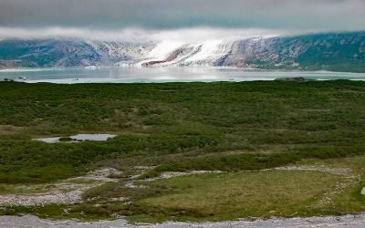
Fourpeaked Glacier, Shelikof Strait
Fourpeaked Glacier starts from the eastern flank of Fourpeaked Mountain with a summit elevation of 6771 feet (2,064 m) and flows generally east for 6 miles (10 km) to a proglacial lake about 2.5 miles (4 km) long that is drained by a river that flows another 0.8 miles (1.3 km) to Shelikof Strait in Katmai National Park and Preserve, about 90 miles (145 km) southwest of Homer and 77 miles (124 km) northwest of Kodiak, Alaska.

South Sawyer Glacier, Tracy Arm
South Sawyer Glacier starts in British Columbia and flows northwest for 31 miles (50 km) to the head of Tracy Arm, about 73 miles (118 km) north of Petersburg and 56 miles (90 km) southeast of Juneau, Alaska.
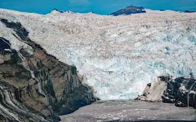
Tsaa Glacier, Icy Bay
Tsaa Glacier flows about 8 miles (13 km) southeast from the northeast flank of the Robinson Mountains and terminates in Tsaa Fjord, on the western coast of Icy Bay, about 147 miles (237 km) east-southeast of Cordova and 75 miles (121 km) northwest of Yakutat, Alaska.
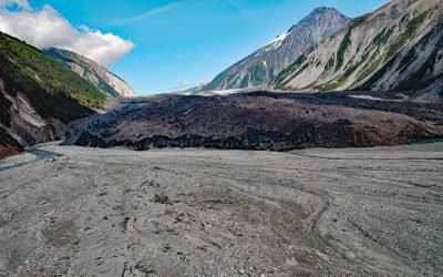
Lituya Glacier, Gilbert Inlet
Lituya Glacier starts on the south flank of Mount Wilbur in the Fairweather Range and flows west for 8 miles (13 km) to the Desolation Valley, and then turns southeast and flows for 2.6 miles (4 km) to Gilbert Inlet, about 100 miles southeast of Yakutat and 68 miles (110 km) northwest of Gustavus, Alaska.
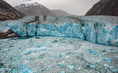
Dawes Glacier, Endicott Arm
Dawes Glacier originates from the Stikine Icefield near the Alaska-Canada boundary and flows northwest for 20 miles (32 km) to tidewater in Endicott Arm, about 100 miles (161 km) northeast of Sitka and 80 miles (129 km) southeast of Juneau, Alaska.
About the background graphic
This ‘warming stripe’ graphic is a visual representation of the change in global temperature from 1850 (top) to 2019 (bottom). Each stripe represents the average global temperature for one year. The average temperature from 1971-2000 is set as the boundary between blue and red. The colour scale goes from -0.7°C to +0.7°C. The data are from the UK Met Office HadCRUT4.6 dataset.
Click here for more information about the #warmingstripes.