Shipwrecks
Recent Articles
More Articles
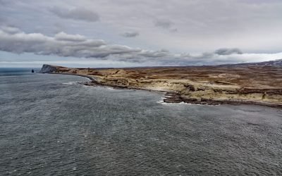
Scotch Cap Light, Unimak Pass
Scotch Cap Light is located on the southwest corner of Unimak Island, and the eastern shore of Unimak Pass, about 714 miles (1151 km) southwest of Anchorage and 81 miles (131 km) northeast of Dutch Harbor, Alaska.
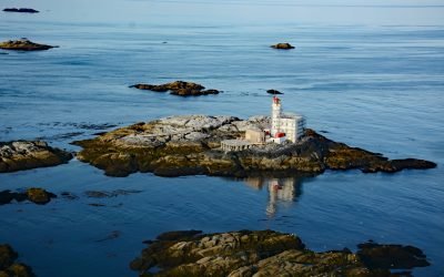
Triple Island, Brown Passage
Triple Island is the site of a large manned light station in Brown Passage, about 83 miles (134 km) south-southeast of Ketchikan and 22 miles (35 km) west-southwest of Prince Rupert, British Columbia.
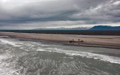
Kaliakh River, Malaspina Coastal Plain
Kaliakh River drains Hanna Lake and flows generally south through the Malaspina Coastal Plain for 24 miles (39 km) to the Gulf of Alaska, about 13 miles (21 km) northwest of Cape Yakataga and 106 miles (171 km) southeast of Cordova, Alaska.
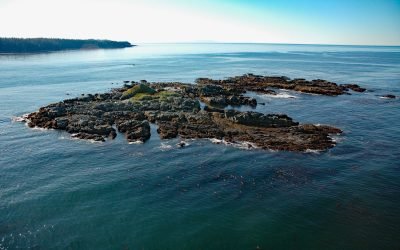
Seabird Rocks, Pacific Rim National Park Reserve
Seabird Rocks are located near the mouth of Pachena Bay in Pacific Rim National Park Reserve, about 35 miles (56 km) northwest of Port Renfrew and 6 miles (10 km) south of Bamfield, British Columbia.
McIver Bight, Unalaska Island
McIver Bight is a cove on the southwestern coast of Unalaska Island, 825 miles (1,330 km) southwest of Anchorage and 38 miles (62 km) southwest of Dutch Harbor, Alaska.
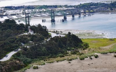
Yaquina Bay Light, Newport
Yaquina Bay Light is located on the north shore of the entrance to Yaquina Bay, about 40 miles (65 km) west of Corvallis and 1 mile (1.6 km) southwest of Newport, Oregon.

Stardust Bay, Sedanka Island
Stardust Bay is situated on the southeast coast of Sedanka Island, which is separated from Unalaska Island by Udagak Strait to the west and Beaver Inlet to the north, about 780 miles (1258 km) southwest of Anchorage and 16 miles (26 km) southeast of Dutch Harbor, Alaska.

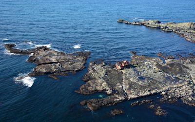
Cape Tanak, Umnak Island
Cape Tanak is a headland on the north coast of Umnak Island in the Eastern Aleutian Islands between Cape Idak to the east and Ashishik Point to the west, about 64 miles (103 km) southwest of Dutch Harbor and 56 miles (90 km) northeast of Nikolski, Alaska.

Teahwhit Head, La Push
Teahwhit Head is a rocky headland with a natural sea arch and the site of a historical shipwreck on the coast of Olympic National Park in the Olympic Coast National Marine Sanctuary, about 12 miles (19 km) southwest of Forks and 2.8 miles (4.5 km) south-southeast of La Push, Washington.

The Hulks, Powell River
The Hulks is a floating breakwater consisting of ship hulls anchored off the mouth of Powell River originally to protect a log pond for a pulp and paper mill, about 28 miles (45 km) southeast of Campbell River and 2 miles (3.2 km) north-northwest of the community of Powell River, British Columbia.
About the background graphic
This ‘warming stripe’ graphic is a visual representation of the change in global temperature from 1850 (top) to 2019 (bottom). Each stripe represents the average global temperature for one year. The average temperature from 1971-2000 is set as the boundary between blue and red. The colour scale goes from -0.7°C to +0.7°C. The data are from the UK Met Office HadCRUT4.6 dataset.
Click here for more information about the #warmingstripes.