Waterfalls
Recent Articles
More Articles
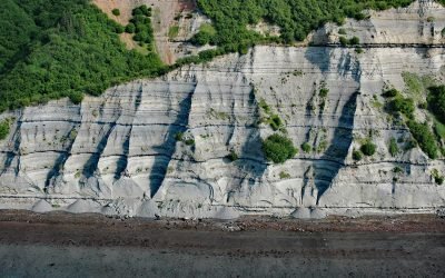
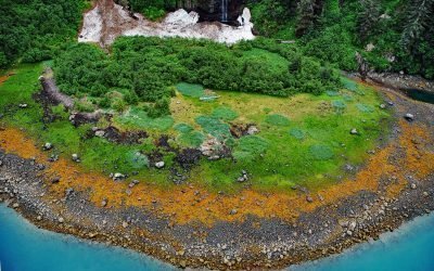
Falls Creek, Kachemak Bay
Falls Creek is located on the Kenai Peninsula, flowing generally south for 3.2 miles (5 km) to the northwestern shore of Kachemak Bay, approximately 17 miles (27 km) northeast of Homer and 2.5 miles (4 km) southwest of Kachemak Selo, Alaska.
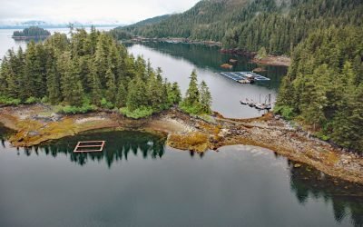
Hidden Falls Hatchery, Kasnyku Bay
The Hidden Falls Fish Hatchery is located in Tongass National Forest on the northeast coast of Baranof Island, at the head of Kasnyku Bay off Chatham Strait, about 22 miles (35 km) south-southeast of Angoon and 21 miles (34 km) northeast of Sitka, Alaska.
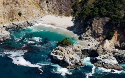
McWay Creek, Julia Pfeiffer Burns State Park
McWay Creek drains a watershed of approximately 1,730 acres (700 ha) and flows southwest for 2.5 miles (4 km) through Julia Pfeiffer Burns State Park and McWay Canyon one Big Sur coast, about 30 miles (48 km) south-southeast of Carmel and 12 miles (19 km) northwest of Lucia, California.
Triumph Bay, Gardner Canal
Triumph Bay is a long narrow embayment located on the south side of Alan Reach in Gardner Canal, British Columbia.
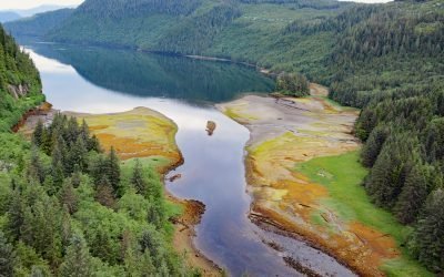
Whale Bay, Prince William Sound
Whale Bay lies on the northeastern coast of the Kenai Peninsula in Prince William Sound, extending 4 miles (6.5 km) northeast to the southern end of Knight Island Passage, about 88 miles (141 km) west-southwest of Cordova and 45 miles (73 km) east of Seward, Alaska.
Rookery Falls, Passage Canal
Rookery Falls is on the northern shore of Passage Canal in Prince William Sound, about 50 miles (80 km) southeast of Anchorage and 1.7 miles (1.9 km) north-northeast of Whittier, Alaska.

Ultramarine Glacier, Blue Fjord
Ultramarine Glacier is located at the head of Blue Fjord, a glacial estuary that trends generally north for 4.5 miles (7.3 km) to Port Nellie Juan in western Prince William Sound on the east coast of the Kenai Peninsula, about 87 miles (140 km) west of Cordova and 26 miles (42 km) southeast of Whittier, Alaska.

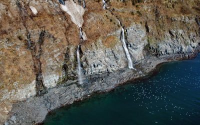
Big Port Walter, Baranof Island
Port Walter is a fjord 3.7 miles (6 km) long that opens into Chatham Strait on the southeast coast of Baranof Island, about 91 miles (146 km) west of Wrangell and 51 miles (82 km) south-southeast of Sitka, Alaska.

Rudyerd Bay, Misty Fjords National Monument
Rudyerd Bay is a deglaciated fjord in the Coast Range of Southeast Alaska in Misty Fjords National Monument, about 89 miles (143 km) north-northwest of Prince Rupert and 39 miles (63 km) northeast of Ketchikan, Alaska.

Beloit Glacier, Blackstone Bay
Beloit Glacier flows northeast for about 2 miles (3.2 km) from an unnamed ice field on the Kenai Peninsula to Blackstone Bay in Prince William Sound, about 86 miles (138 km) southwest of Valdez and 9 miles (15 km) south of Whittier, Alaska.
About the background graphic
This ‘warming stripe’ graphic is a visual representation of the change in global temperature from 1850 (top) to 2019 (bottom). Each stripe represents the average global temperature for one year. The average temperature from 1971-2000 is set as the boundary between blue and red. The colour scale goes from -0.7°C to +0.7°C. The data are from the UK Met Office HadCRUT4.6 dataset.
Click here for more information about the #warmingstripes.