Rivers
Recent Articles
More Articles
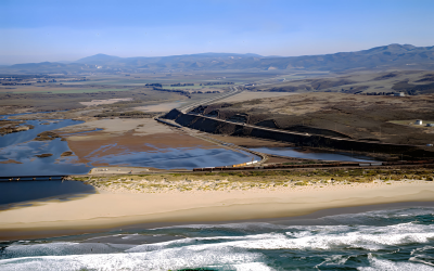
Surf Beach, Santa Ynez River
Surf Beach is within Vandenberg Space Force Base and extends south-southwest for about 4.5 miles (7.3 km) from the mouth of the Santa Ynez River estuary to Spring Canyon, about 31 miles (50 km) south of Pismo Beach and 9 miles (14.5 km) west-northwest of Lompoc, California.
Mary D. Hume, Rogue River
Mary D. Hume sank in 1984 on the south bank of the Rogue River during a restoration effort to convert the vessel to a museum ship for the Curry County Historical Society and now rests on the bottom in shallow water with a portion of the hull and superstructure exposed at low tide near Gold Beach, Oregon.
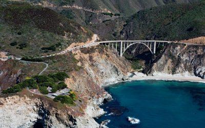
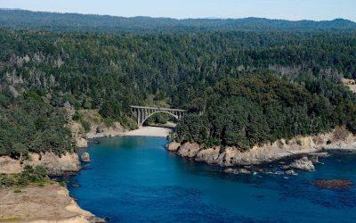
Bixby Creek, Big Sur
Bixby Creek starts at the confluence of Mill Creek and Turner Creek that flow from an elevation of 2,500 feet (762 m) on the west flank of Skinner Ridge for a total run of about 7 miles (11 km) through the Santa Lucia Mountains to the Big Sur coast, between Hurricane Point to the south and Division Knoll to the north, about 16 miles (26 km) south of Monterey and 9 miles (15 km) northwest of the community of Big Sur, California.
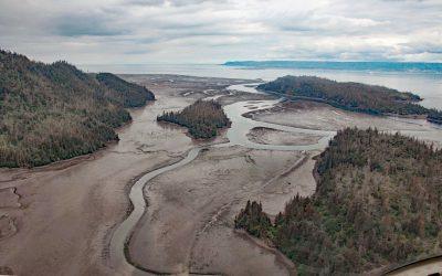
China Poot Creek, Kachemak Bay
China Poot Creek starts at an elevation of about 3,500 feet (1,067 m) on the western flank of the Kenai Mountains and flows for 5.6 miles (9 km) to China Poot Lake, also called Leisure Lake, at an elevation of 168 feet (51 m), and then for another 0.9 miles (1.5 km) to China Poot Bay on the southeastern shore of Kachemak Bay, about 19 miles (31 km) northeast of Seldovia and 13 miles (21 km) southeast of Homer, Alaska.
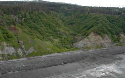
Russian Gulch, Mendocino Coast
Russian Gulch is a river that starts at an elevation of about 800 feet (244 m) on the northwestern flank of Hi Chute Ridge in the California Coast Ranges and flows generally northwest for 5 miles (8 km) to the Pacific Ocean, draining a watershed of 2,456 acres (994 ha) in Russian Gulch State Park, about 2 miles (3.3 km) north of Mendocino and 7 miles (11 km) south of Fort Bragg, California.
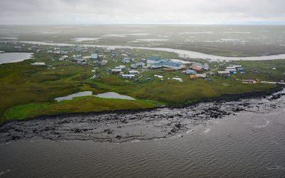
Newtok, Yukon-Kuskokwim Delta
Newtok is a Central Yup’ik community located between the Ningaluk River to the south and a tidal slough to the north, 19 miles (31 km) upstream from the Bering Sea in the Yukon-Kuskokwim Delta, about 125 miles (202 km) south of Emmonak and 96 miles (155 km) west of Bethel, Alaska.
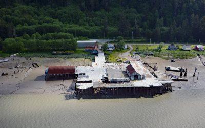
Cassiar Cannery, Skeena River
Cassiar is a historic salmon cannery situated on the northern shoreline of Inverness Passage at the mouth of the Skeena River, about 67 miles (18 km) southwest of Terrace and 11 miles (18 km) southeast of Prince Rupert, British Columbia.
Diamond Creek, Kachemak Bay
Diamond Creek starts at an elevation of about 1,000 feet (305 m) on the southern Kenai Peninsula and drains a watershed of 3,424 acres (1,386 ha) while flowing generally west for about 5 miles (8 km) from Diamond Ridge to the northern shore of Kachemak Bay, about 10 miles (16 km) southeast of Anchor Point and 6 miles (10 km) west-northwest of Homer, Alaska.
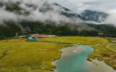
Speel Arm, Port Snettisham
Speel Arm extends generally northeast for 9 miles (14.5 km) from the head of Port Snettisham to the mouth of the Speel River, and is the site of a hydroelectric facility powered by water from Crater Lake and Long Lake, about 95 miles (153 km) northeast of Sitka and 30 miles (48 km) southeast of Juneau, Alaska.
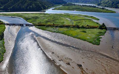
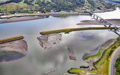
Blacks Island, Smith River
Blacks Island is situated at the confluence of the Smith River and the Umpqua River, on the historic spur line of the Southern Pacific Railroad connecting Eugene with Coos Bay, about 1.7 miles (2.7 km) southeast of Gardiner and 1 mile (1.6 km) northeast of Reedsport, Oregon.
About the background graphic
This ‘warming stripe’ graphic is a visual representation of the change in global temperature from 1850 (top) to 2019 (bottom). Each stripe represents the average global temperature for one year. The average temperature from 1971-2000 is set as the boundary between blue and red. The colour scale goes from -0.7°C to +0.7°C. The data are from the UK Met Office HadCRUT4.6 dataset.
Click here for more information about the #warmingstripes.