Canneries
Recent Articles
More Articles

Carlisle Cannery, Skeena River
Carlisle is a historical remote salmon cannery on the east bank at the mouth of the Skeena River, about 66 miles (106 km) southwest of Terrace and 17 miles (27 km) southeast of Prince Rupert, British Columbia.
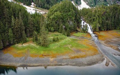
Cliff Falls, Deep Cove
Cliff Falls is the outlet for Cliff Lake, located at the head of Deep Cove, approximately 1.1 miles (1.8 km) west of Patterson Point, about 41 miles (66 km) south-southeast of Sitka, and 17.5 miles (28 km) north-northwest of Port Armstrong, Alaska.

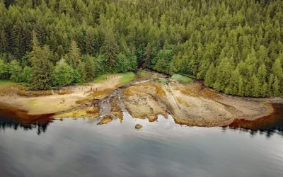
Mush Bay, East Arm Uganik Bay
Mush Bay is a local name for a shallow embayment on the western shore of the East Arm of Uganik Bay on Kodiak Island’s west coast, about 22 miles (35 km) northeast of Larsen Bay and 40 miles (65 km) west-southwest of Kodiak, Alaska.

Humpback Bay, Porcher Island
Humpback Bay is an embayment on the north coast of Porcher Island off Malacca Passage, about 15 miles (24 km) south of Prince Rupert, British Columbia.

Chip Cove Cannery, Moser Bay
Chip Cove is an embayment between Luchek Mountain to the south and Peak 2001 to the north, and the site of a historical salmon cannery on the western shore of Moser Bay near Olga Narrows on the southwestern coast of Kodiak Island, about 83 miles (131 km) southwest of Kodiak and 6 miles (10 km) north of Akhiok, Alaska.

Copper Harbor, Hetta Inlet
Copper Harbor is an embayment on Prince of Wales Island on the eastern shore of Hetta Inlet, near the historical Coppermount mine, about 38 miles (61 km) west-southwest of Ketchikan and 8.6 miles (14 km) east-northeast of Hydaburg, Alaska.

Ford Arm, Chichagof Island
Ford Arm is an embayment approximately 0.3 miles (483 m) wide and 4 miles (6.5 km) long on the west coast of Chichagof Island, about 44 miles (71 km) north-northwest of Sitka and 28 miles (44 km) south-southeast of Pelican, Alaska.

MacDonald Spit, Kasitsna Bay
MacDonald Spit forms the northwestern shore of Kasitsna Bay on the southern coast of Kachemak Bay, approximately 11 miles (18 km) south of Homer and 5 miles (8 km) northeast of Seldovia, Alaska.

Lindenberger Cannery, Craig Island
The Lindenberger Packing Company is a historical salmon cannery on Craig Island, located in the present-day community of Craig, about 58 miles (93 km) west-northwest of Ketchikan and 6 miles (10 km) south-southwest of Klawock, Alaska.
Cape Fox Packing Company Cannery, Boca de Quadra
The Cape Fox Packing Company operated a cannery from 1883 to 1886 on the north shore of Boca de Quadra, a fjord on the Portland Peninsula, about 59 miles (95 km) north-northwest of Prince Rupert and 36 miles (58 km) southeast of Ketchikan, Alaska.
About the background graphic
This ‘warming stripe’ graphic is a visual representation of the change in global temperature from 1850 (top) to 2019 (bottom). Each stripe represents the average global temperature for one year. The average temperature from 1971-2000 is set as the boundary between blue and red. The colour scale goes from -0.7°C to +0.7°C. The data are from the UK Met Office HadCRUT4.6 dataset.
Click here for more information about the #warmingstripes.