Historical Sites
Recent Articles
More Articles
Fort Nisqually, Sequalitchew Creek
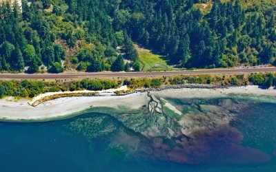
Fort Nisqually was a historical trading post established by the Hudson’s Bay Company in 1833 on Sequalitchew Creek, 1.3 miles (2.1 km) east of South Puget Sound at an elevation of 220 feet (67 m), about 14 miles (22.5 km) southwest of Tacoma and 2 miles (3.2 km) northwest of Dupont, Washington.

Lawson Harbour, Lewis Island
Lawson Harbour was a historical community on Lewis Island between Chismore Passage to the west and Arthur Passage to the east near the mouth of the Skeena River, about 75 miles (121 km) southwest of Terrace and 20 miles (32 km) south of Prince Rupert, British Columbia.

Stebbins, Saint Michael Island
Stebbins is a community in southern Norton Sound situated on a small sand spit along the northern shore of Saint Michael Island at Cape Stephens, which is in the lee of Stuart Island to the northwest and separated by a channel 1 mile (1.6 km) wide named Stephens Pass, about 117 miles (188 km) southeast of Nome and 52 miles (84 km) southwest of Unalakleet, Alaska.
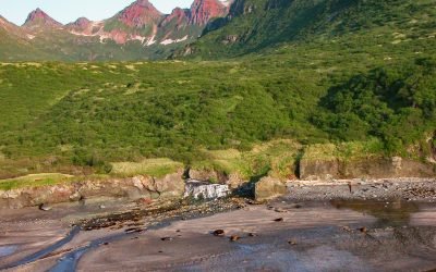
Kaflia Bay, Katmai National Park and Preserve
Kaflia Bay is a funnel-shaped embayment that extends west for 4 miles (6.5 km) from the coast of Shelikof Strait between Cape Ugyak to the north and Cape Gull to the south in Katmai National Park and Preserve, about 93 miles (150 km) southeast of King Salmon and 75 miles (121 km) northwest of Kodiak, Alaska.

Hoonah, Port Frederick
Hoonah is a community situated on the eastern shore of Port Frederick on the northeastern coast of Chichagof Island in the Alexander Archipelago of Southeast Alaska, about 40 miles (64 km) west-southwest of Juneau and 24 miles (39 km) south-southeast of Gustavus, Alaska.

Fort Tongass, Nakat Bay
Tongass Island is the historical site of Fort Tongass located near the southern extent of the Alexander Archipelago in Southeast Alaska about 4.5 miles (7 km) north of the Canadian Border, bounded by Nakat Bay to the west and a channel called Port Tongass to the east, about 19 miles (31 km) northwest of Lax Kw’alaams, British Columbia and 54 miles (87 km) southeast of Ketchikan, Alaska.

Telegraph Point, Skeena River
Telegraph Point is the historical site of a telegraph station on the north bank of the Skeena River, about 48 miles (77 km) southwest of Terrace and 28 miles (45 km) southeast of Prince Rupert, British Columbia.

Nunagiak, Point Belcher
Nunagiak is an abandoned village at Point Belcher that dates to the prehistorical Thule culture, located about 78 miles (126 km) southwest of Utquiagvik and 15 miles (24 km) northeast of Wainwright, Alaska.

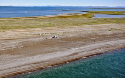
Dutton, Cottonwood Bay
Dutton is a historical mining camp at the mouth of Ptarmigan Creek at the head of Cottonwood Bay, about 78 miles (126 km) west of Homer and 18 miles (29 km) southeast of Pedro Bay, Alaska.
Jabbertown, Point Hope
Jabbertown is a historical shore whaling station on the Chukchi Sea coast, about 150 miles (242 km) northwest of Kotzebue and 2.5 miles (4 km) southeast of Point Hope, also known as Tikiġaq or Tigara, Alaska.
About the background graphic
This ‘warming stripe’ graphic is a visual representation of the change in global temperature from 1850 (top) to 2019 (bottom). Each stripe represents the average global temperature for one year. The average temperature from 1971-2000 is set as the boundary between blue and red. The colour scale goes from -0.7°C to +0.7°C. The data are from the UK Met Office HadCRUT4.6 dataset.
Click here for more information about the #warmingstripes.