Islands
Recent Articles
More Articles
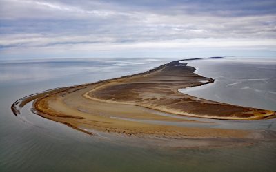
Solivik Island, Utukok Pass
Solivik Island is an Arctic barrier island that extends southwest for 16.5 miles (27 km) from Icy Cape Pass in the north to Utukok Pass in the south and forms the northern portion of Kasegaluk Lagoon, about 69 miles (111 km) southwest of Wainwright and 28 miles (45 km) north-northeast of Point Lay, Alaska.

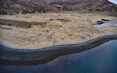
Cape Kookoolik, Saint Lawrence Island
Kookoolik is a historical community, also known as Kukulik, located on Cape Kookoolik on the northern coast of Saint Lawrence Island, about 160 miles (258 km) southwest of Nome and 4 miles (6.5 km) east of Savoonga, Alaska.

Washington Bay, Kuiu Island
Washington Bay trends east for 2 miles (3.2 km) on the northwest coast of Kuiu Island and is the site of a historical herring reduction facility near the head of the bay that is flanked by steep mountains rising abruptly to 2,800 feet (853 m) on the north and 2,200 feet (671 m) on the south, about 143 miles (230 km) northwest of Ketchikan and 24 miles (39 km) southwest of Kake, Alaska.

Blubber Bay, Texada Island
Blubber Bay is a community and an embayment on the northern tip of Texada Island, between the Strait of Georgia to the west and Malaspina Strait to the east, and the site of a historical shore whaling station and present-day limestone mine, about 76 miles (122 km) northwest of Vancouver and 5 miles (8 km) southwest of Powell River, British Columbia.
Ikatan Peninsula, Unimak Island
Ikatan Peninsula is connected to the northeastern tip of Unimak Island by a sand spit or tombolo separating Ikatan Bay to the north from Otter Cove to the south and is the site of the historical community of Ikatan, about 143 miles (230 km) northeast of Unalaska and 8 miles (13 km) south-southeast of False Pass, Alaska.
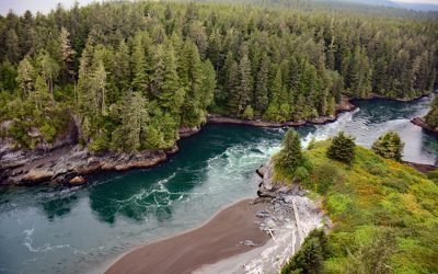
Whyac, Nitinat Narrows
Whyac is a historical Ditidaht First Nation village on the southern shore beside Nitinat Narrows, a tidal channel about 1.9 miles (3 km) long that connects Nitinat Lake to the Pacific Ocean on the north shore of the Strait of Juan de Fuca on Vancouver Island, about 22 miles (35 km) northwest of Port Renfrew and 17 miles (27 km) southeast of Bamfield, British Columbia.

Hunter Bay, Prince of Wales Island
Hunter Bay is the estuary for several watersheds that support important sockeyes salmon populations and the site of a historical salmon cannery on the west coast of Prince of Wales Island near the abandoned village of Klinkwan, about 89 miles (143 km) northwest of Prince Rupert, British Columbia, and 42 miles (68 km) southwest of Ketchikan, Alaska.
Naukati Bay, Prince of Wales Island
Naukati Bay is a community at the site of a former logging camp and log transfer facility situated on a peninsula on the western coast of Prince of Wales Island between Little Naukati Bay to the northwest, Kaikli Cove to the northeast, Naukati Bay to the east, and across Tuxekan Passage from Tuxekan Island to the west, about 71 miles (114 km) northwest of Ketchikan and 18 miles (29 km) southwest of Coffman Cove, Alaska.

Calder, Shakan Strait
Calder is a mining camp for a historic marble quarry and present-day limestone mine situated at the mouth of Marble Creek on Shakan Strait near the entrance to El Capitan Passage on Prince of Wales Island, about 92 miles (148 km) northwest of Ketchikan and 12 miles (19 km) south-southeast of Port Protection, Alaska.

Cape Pole, Kosciusko Island
Cape Pole is a historical logging community at Cape Pole on the eastern shore of Fishermans Harbor on Kosciusko Island, about 92 miles (148 km) northwest of Ketchikan and 6.7 miles (11 km) west of Edna Bay, Alaska.
About the background graphic
This ‘warming stripe’ graphic is a visual representation of the change in global temperature from 1850 (top) to 2019 (bottom). Each stripe represents the average global temperature for one year. The average temperature from 1971-2000 is set as the boundary between blue and red. The colour scale goes from -0.7°C to +0.7°C. The data are from the UK Met Office HadCRUT4.6 dataset.
Click here for more information about the #warmingstripes.