Islands
Recent Articles
More Articles
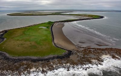
Cape Etolin, Nunivak Island
Cape Etolin is a point of land extending about 4.6 miles (7.4 km) north into the Bering Sea on the northern coast of Nunivak Island, about 50 miles (80 km) west of Nightmute on the mainland and 4 miles (6 km) north-northeast of Mekoryuk, Alaska.
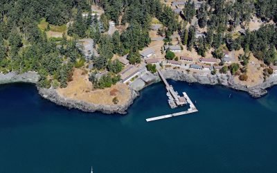
Friday Harbor Laboratories, San Juan Island
Friday Harbor Laboratories is a marine biology field station of the University of Washington situated on the northern shore of Friday Harbor, an embayment on the eastern coast of San Juan Island, about 72 miles (116 km) northwest of Seattle and 18 miles (29 km) west of Anacortes, Washington.
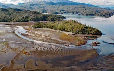
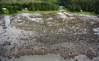
Chugachik Island, Kachemak Bay
Chugachik Island lies between Bear Cove to the south and Martin River to the north on the Kenai Peninsula, about 18 miles (29 km) northeast of Homer and 3.3 miles (5.3 km) south-southeast of Kachemak Selo, Alaska.
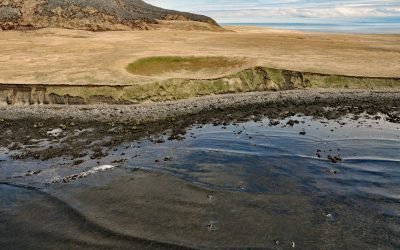
Amak Island, Bering Sea
Amak is a volcanic island situated in the Bering Sea that measures about 2 miles (3.2 km) wide and nearly 3 miles (4.8 km) longitudinally, about 172 miles (277 km) northeast of Dutch Harbor and 22 miles (35 km) northwest of Cold Bay, Alaska.

Anacortes Ferry Terminal, Guemes Channel
Anacortes ferry terminal is located at Ship Harbor, an embayment on the northwestern shore of Fidalgo Island and the southern shore of Guemes Channel, about 85 miles (137 km) north of Seattle and 3.7 miles (6 km) west of the community of Anacortes, Washington.
Osland, Smith Island
Osland was once an active fishing and boatbuilding community on the east coast of Smith Island at the mouth of the Skeena River, about 68 miles (109 km) southwest of Terrace and 14 miles (23 km) south-southeast of Prince Rupert, British Columbia.
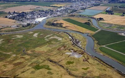
Leque Island, South Pass Stillaguamish River
Leque Island is located at the mouth of the Stillaguamish River on South Pass channel that separates Camano Island from the mainland, about 43 miles (69 km) north of Seattle and 0.6 miles (1 km) southwest of Stanwood, Washington.
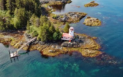
Sitka Lighthouse, Galankin Islands
Sitka Lighthouse is privately owned and located at the northwestern end of Galankin Island in Sitka Sound between the Beardslee Islands to the west and Ball Islets to the east, about 43 miles (69 km) southwest of Angoon and 1 mile (1.6 km) south-southwest of Sitka, Alaska.

Cape Elizabeth, Chugach Islands
Cape Elizabeth forms the western shore of Elizabeth Island and is located on the north side of Kennedy Entrance, about 96 miles (155 km) north-northeast of Kodiak and 36 miles (58 km) south-southwest of Homer, Alaska.
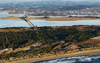
Tuluwat Island, Humboldt Bay
Tuluwat Island, also known as Gunther Island or Indian Island, is the largest of three islands in Humboldt Bay, along with Woodley and Dalby Islands, approximately 5.5 miles (8.8 km) south-southwest of Arcata and within the city limits of Eureka, California.
About the background graphic
This ‘warming stripe’ graphic is a visual representation of the change in global temperature from 1850 (top) to 2019 (bottom). Each stripe represents the average global temperature for one year. The average temperature from 1971-2000 is set as the boundary between blue and red. The colour scale goes from -0.7°C to +0.7°C. The data are from the UK Met Office HadCRUT4.6 dataset.
Click here for more information about the #warmingstripes.