
Alaska
Recent Articles
More Articles

Chignik Lagoon, Alaska Peninsula
Chignik Lagoon is an embayment that trends southwest for 8.5 miles (14 km) from the head of Chignik Bay to the mouth of Chignik River on the Gulf of Alaska coast of the Alaska Peninsula, about 45 miles (73 km) south of Port Heiden and 5 miles (8 km) west-northwest of the community of Chignik, Alaska.

Swanson River, Number Three Bay
Swanson River starts at an elevation of 224 feet (68 m) at the outlet of Gene Lake in the Swan Lake district on the Kenai Peninsula and flows generally southwest for 40 miles (64 km), draining a watershed of 162,496 acres (65,760 ha), to Number Three Bay on the southeastern shore of Cook Inlet, about 47 miles (76 km) southwest of Anchorage and 19 miles (31 km) north-northeast of Kenai, Alaska.

Kupigruak Channel, Colville River Delta
Kupigruak Channel is one of two main distributaries in the Colville River Delta located about halfway between Utqiagvik at Point Barrow to the west and Kaktovik on Barter Island to the east, about 52 miles (84 km) west-northwest of Deadhorse and 18 miles (29 km) north-northwest of Nuiqsut, Alaska.

Ivanof Bay, Alaska Peninsula
Ivanof Bay is a community on the Alaska Peninsula at the head of Ivanof Bay, an estuary of the Ivanof River that starts at an elevation of roughly 1000 feet (305 m) on the south flank of the Alaska Peninsula and flows generally southwest for 9 miles (15 km) draining a watershed of 15,545 acres (6,291 ha), about 57 miles (92 km) northeast of Sand Point and 13 miles (21 km) west of Perryville, Alaska.

Deep Bay, Peril Strait
Deep Bay is an estuary about 0.5 miles (0.8 km) across, located on the western shore of Peril Strait, on the southern coast of Chichagof Island, about 74 miles (119 km) southwest of Juneau and 29 miles (47 km) northwest of Sitka, Alaska.

Paint River, Akjemguiga Cove
Paint River starts at the confluence of the Middle and South Forks and flows generally east for 17 miles (27 km), draining a watershed of 40,854 acres (16,533 ha), to Akjemguiga Cove in Kamishak Bay between McNeil Cove to the south and Amakdedulia Cove to the north, about 101 miles (163 km) southwest of Homer and 94 miles (152 km) northeast of King Salmon, Alaska.

Point Lay Village, Kokolik River
Point Lay Village is a community at the mouth of the Kokolik River on Kasegaluk Lagoon, about 94 miles (152 km) southwest of Wainwright and 134 miles (216 km) northeast of Point Hope, Alaska.
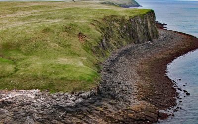
Kiukpalik Island, Shelikof Strait
Kiukpalik Island is 1.3 miles (2 km) long and 0.6 miles (1 km) wide and is part of Katmai National Park and Preserve, but situated 2 miles (3.2 km) offshore from the Alaska Peninsula in Shelikof Strait, about 112 miles (181 km) east of King Salmon and 72 miles (116 km) northwest of Kodiak, Alaska.
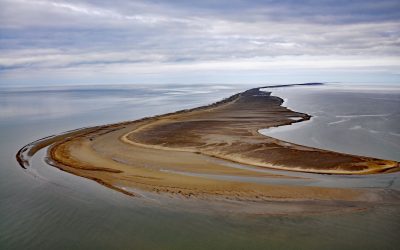
Solivik Island, Utukok Pass
Solivik Island is an Arctic barrier island that extends southwest for 16.5 miles (27 km) from Icy Cape Pass in the north to Utukok Pass in the south and forms the northern portion of Kasegaluk Lagoon, about 69 miles (111 km) southwest of Wainwright and 28 miles (45 km) north-northeast of Point Lay, Alaska.
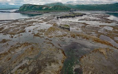
Amakdedulia Cove, Kamishak Bay
Amakdedulia Cove is an embayment about 2 miles (3.2 km) across on the western shore of Kamishak Bay in southwestern Cook Inlet, about 98 miles (158 km) northeast of King Salmon and 98 miles (158 km) southwest of Homer, Alaska.
About the background graphic
This ‘warming stripe’ graphic is a visual representation of the change in global temperature from 1850 (top) to 2019 (bottom). Each stripe represents the average global temperature for one year. The average temperature from 1971-2000 is set as the boundary between blue and red. The colour scale goes from -0.7°C to +0.7°C. The data are from the UK Met Office HadCRUT4.6 dataset.
Click here for more information about the #warmingstripes.