Beaches
Recent Articles
More Articles

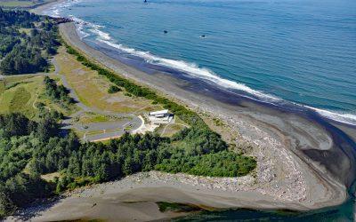
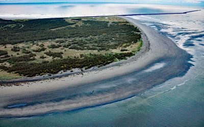
Coal Point, Homer Spit
Coal Point forms the tip of the Homer Spit in Kachemak Bay on the southern Kenai Peninsula, about 15 miles (24 km) northeast of Seldovia and 5.7 miles (9 km) southeast of Homer, Alaska.
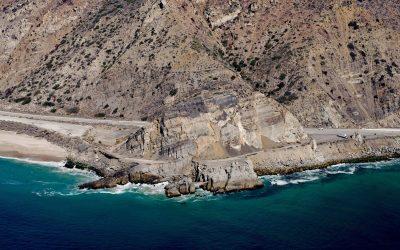
Mugu Rock, Point Mugu State Park
Mugu Rock is a distinctive feature at Point Mugu, a headland in Point Mugu State Park, situated between Thornhill Broome Beach to the east and Mugu Beach to the west in Santa Monica National Recreation Area, about 17 miles (27 km) west-northwest of Malibu, and 9 miles (14.5 km) southeast of Port Hueneme, California.

Peter Iredale, Clatsop Spit
Peter Iredale was a British four-masted bark-rigged sailing ship with a length of 275 feet (84 m) that ran aground in 1906 and wrecked on Clatsop Spit, about 7 miles (11 km) west of Astoria and 2 miles ( km) southwest of Hammond, Oregon.
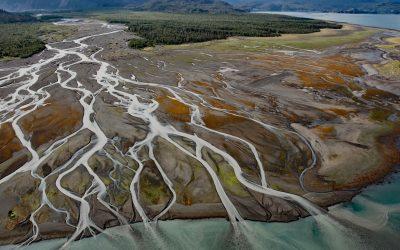
Grewingk Creek, Kachemak Bay
Grewingk Creek drains a glaciated watershed of 29,138 acres (11,792 ha) and flows generally northwest for 3.5 miles (5.6 km) from the terminus lake of the retreating Grewingk Glacier to the southeastern shore of Kachemak Bay, about 24 miles (39 km) northeast of Seldovia and 13 miles (21 km) east of Homer, Alaska.

Tennessee Cove, Golden Gate National Recreation Area
Tennessee Cove is an embayment with a sandy beach about 600 feet (180 m) long on the Pacific Ocean between Pirates Cove to the north and Rodeo Cove to the south in Golden Gate National Recreation Area about 10 miles (16 km) northwest of San Francisco and 3.6 miles (5.8 km) southwest of Mill Valley, California.
Winchuk River, Crissey Field
Winchuck River starts at an elevation of about 2,000 feet (610 m) and flows generally southwest for 19 miles (31 km) through the Rogue River–Siskiyou National Forest to the Pacific Ocean at Crissey Field, about 17 miles (27 km) north of Crescent City and 4.8 miles (7.7 km) southeast of Brookings, Oregon.
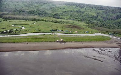
Polly Creek, Cook Inlet
Polly Creek and Little Polly Creek drain a combined watershed of 16,113 acres (6,521 ha), on the southern flank of an unnamed ridge that extends southeast from the summit of Mount Redoubt, and flow generally south for 9 miles (14.5 km) and 8 miles (12.8 km) respectively to the western shore of Cook Inlet, about 56 miles (90 km) northwest of Homer and 46 miles (74 km) southwest of Kenai, Alaska.

King Philip, Ocean Beach
King Philip was a clipper ship that wrecked in 1878 on Ocean Beach, on the west coast of the San Francisco Peninsula in the Sunset District, about 1 mile (1.6 km) south of Golden Gate Park and 7 miles (11 km) west-southwest of downtown San Francisco, California.

La Jenelle, Silver Strand
La Jenelle was a passenger ship that went aground and wrecked in 1970 on Silver Strand at Port Hueneme, a sandy beach created partly from dredged harbor sand about 1 mile (1.6 km) long and 450 feet(140 m) wide, about 33 miles (53 km) southeast of Santa Barbara and 3.3 miles (5.3 km) south of Oxnard, California.
Clatsop Spit, Columbia River Bar
Clatsop Spit is part of Fort Stevens State Park that projects north from the south bank of the Columbia River and the submerged portion forms the Columbia River Bar, about 80 miles (129 km) northwest of Portland and 9 miles (15 km) west-northwest of Astoria, Oregon.
About the background graphic
This ‘warming stripe’ graphic is a visual representation of the change in global temperature from 1850 (top) to 2019 (bottom). Each stripe represents the average global temperature for one year. The average temperature from 1971-2000 is set as the boundary between blue and red. The colour scale goes from -0.7°C to +0.7°C. The data are from the UK Met Office HadCRUT4.6 dataset.
Click here for more information about the #warmingstripes.