Beaches
Recent Articles
More Articles
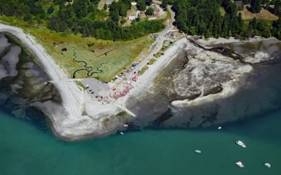
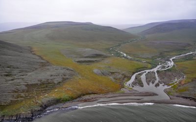
Hoko River, Kydaka Point
Hoko River starts in the foothills of the Olympic Mountains at an elevation of roughly 1150 feet (351 m) and flows generally north for 25 miles (40 km), draining a rugged heavily logged watershed of 48,000 acres (19,425 ha) to Kydaka Point on the Strait of Juan de Fuca, about 13 miles (21 km) southeast of Neah Bay and 3.3 miles (5 km) northwest of Sekiu, Washington.
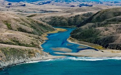
Estero Americano, Bodega Bay
Estero Americano is an estuary about 4 miles (6.5 km) long that connects to Bodega Bay and is fed by Americano Creek that starts at an elevation of roughly 250 feet (76 m) in the coastal hills of Sonoma and Marin Counties and flows west for 11 miles (18 km) draining a watershed of 24,277 acres (9,825 ha), about 19 miles (31 km) southwest of Santa Rosa and 3.7 miles (6 km) northwest of Dillion Beach, California.
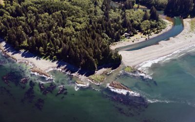
Little Boston, Point Julia
Little Boston is a community at the base of Point Julia on the east side entrance of Port Gamble, an inlet on the Kitsap Peninsula near the entrance to Hood Canal, about 21 miles (34 km) northwest of Seattle and 20 miles (32 km) southeast of Port Townsend, Washington.
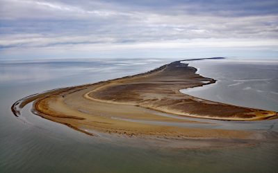
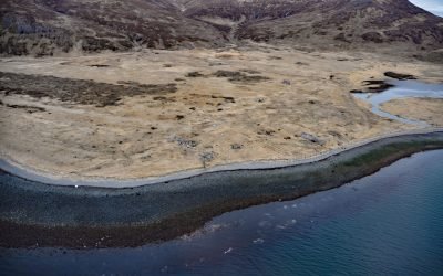
Solivik Island, Utukok Pass
Solivik Island is an Arctic barrier island that extends southwest for 16.5 miles (27 km) from Icy Cape Pass in the north to Utukok Pass in the south and forms the northern portion of Kasegaluk Lagoon, about 69 miles (111 km) southwest of Wainwright and 28 miles (45 km) north-northeast of Point Lay, Alaska.
Kapaloak Creek, Cape Dyer
Kapaloak Creek starts from an elevation of roughly 1200 feet (366 m) in the Lisburne Hills and flows generally west for 8.5 miles (14 km) to Cape Dyer on the Chukchi Sea and the site of a historical Iñupiat village, about 110 miles (177 km) southwest of Point Lay and 25 miles (40 km) north-northeast of Point Hope, Alaska.
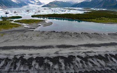
Bear Glacier, Aialik Peninsula
Bear Glacier starts from an elevation of roughly 4,000 feet (1,219 m) on the eastern flank of the Harding Icefield in Kenai Fjords National Park and descends generally southeast for 17 miles (27 km) to a proglacial lake dammed by a terminal moraine between Bear Glacier Point on the Aialik Peninsula to the south and Callisto Head to the north, about 72 miles (116 km) east-northeast of Homer and 13 miles (21 km) south of Seward, Alaska.
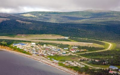
Elim, Norton Bay
Elim is a mixed Central Yup’ik and Iñupiaq community situated on the Iditarod Trail at the mouth of Elim Creek on the Seward Peninsula and the north shore of Norton Bay, about 39 miles (63 km) southwest of Koyuk and 24 miles (38 km) east-northeast of Golovin, Alaska.
Ikatan Peninsula, Unimak Island
Ikatan Peninsula is connected to the northeastern tip of Unimak Island by a sand spit or tombolo separating Ikatan Bay to the north from Otter Cove to the south and is the site of the historical community of Ikatan, about 143 miles (230 km) northeast of Unalaska and 8 miles (13 km) south-southeast of False Pass, Alaska.
Kenai, Cook Inlet
Kenai is a community situated at the site of Shk’ituk’t, a historical Dena’ina village located on the west coast of the Kenai Peninsula, on the eastern shore of Cook Inlet at the mouth of the Kenai River, about 65 miles (15 km) southwest of Anchorage and 64 miles (103 km) north of Homer, Alaska.
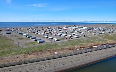
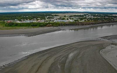
Point Hope, Marryat Inlet
Point Hope is an Iñupiaq whaling community also known as Tikiġaq or Tigara, situated on a barrier spit that extends northwest from Cape Thompson and joins another spit that extends southwest from the Lisburne Peninsula to enclose several lagoons including Marryat Inlet and forms the Tigara Peninsula, about 228 miles (367 km) southwest of Wainwright and 73 miles (118 km) northwest of Kivalina, Alaska.
About the background graphic
This ‘warming stripe’ graphic is a visual representation of the change in global temperature from 1850 (top) to 2019 (bottom). Each stripe represents the average global temperature for one year. The average temperature from 1971-2000 is set as the boundary between blue and red. The colour scale goes from -0.7°C to +0.7°C. The data are from the UK Met Office HadCRUT4.6 dataset.
Click here for more information about the #warmingstripes.