
by CoastView | Aug 2, 2025 | 2025, Alaska, Climate Change, Coastal Features, Glaciers, Historical, Kachemak, Natural History, Parks, Rivers
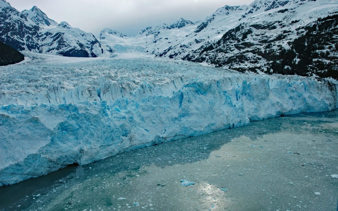
Listen to the article here https://coastview.org/wp-content/uploads/2025/06/Grewingk-Glacier.mp3 Grewingk Glacier originates from an icefield in the Kenai Mountains and flows northwest to the southern shore of Kachemak Bay, about 25 miles (40 km) northeast of Seldovia...

by CoastView | Jul 26, 2025 | 2025, Alaska, Biodiversity, Climate Change, Coastal Features, Embayments, Historical, Kachemak, Natural History, Rivers
Listen to the article here https://coastview.org/wp-content/uploads/2025/06/Travers-Creek.mp3 Travers Creek flows generally west-southwest to the north shore of Kachemak Bay, approximately 3.5 miles (5.5 km) south of Anchor Point and 12 miles (19 km) northwest of...

by CoastView | Jul 3, 2025 | 2025, Alaska, Climate Change, Coastal Features, Embayments, Historical, Land Use, Natural History, Rivers
Listen to the article here https://coastview.org/wp-content/uploads/2025/05/Fish-Creek.mp3 Fish Creek flows generally northeast for approximately 110 miles (177 km) to Harrison Bay at the western edge of the Colville River Delta, about 141 miles (230 km) southeast of...

by CoastView | Jun 26, 2025 | 2025, Alaska, Climate Change, Coastal Features, Embayments, Glaciers, Historical, Natural History, Parks
Listen to the article here https://coastview.org/wp-content/uploads/2025/05/Valerie-Glacier.mp3 Valerie Glacier is formed by several tributary glaciers that merge and flow southeast for about 14 miles (22.5 km) to join the Hubbard Glacier and terminate in...
by CoastView | Jun 10, 2025 | 2025, Alaska, Climate Change, Coastal Features, Embayments, Glaciers, Historical, Natural History
Listen to the article here https://coastview.org/wp-content/uploads/2025/05/Meares-Glacier.mp3 Meares Glacier starts at an elevation of about 7200 feet (2195 m) in the Chugach Mountains between Mount Michelson to the north and Columbia Peak to the south and trends...

by CoastView | Jun 3, 2025 | 2025, Alaska, Chemical Pollution, Climate Change, Coastal Features, Developments, Historical, Land Use, Natural History
Listen to the article here https://coastview.org/wp-content/uploads/2025/05/Point-Lonely.mp3 Originally a Cold War Distant Early Warning facility, Lonely was decommissioned in 2018 and is now an unattended airstrip on the Beaufort Sea coast at Pitt Point, about 83...