Islands
Recent Articles
More Articles
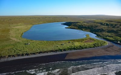
Nash Harbor, Nunivak Island
Nash Harbor is a historic settlement situated at the outlet of a lagoon on the south shore of an embayment also named Nash Harbor bounded by Cape Algonquin to the west and Chingeeruk Point to the east, on the north coast of Nunivak Island, about 96 miles (155 km) south-southwest of Hooper Bay and 30 miles (48 km) southwest of Mekoryuk, Alaska.
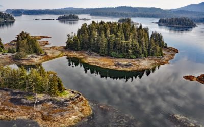
Christmas Island, Security Bay
Christmas Island is the largest of several small reefs and islets on the western coastline and near the entrance to Security Bay on Kuiu Island, about 45 miles (72 km) south of Angoon and 18 miles (29 km) southwest of Kake, Alaska.
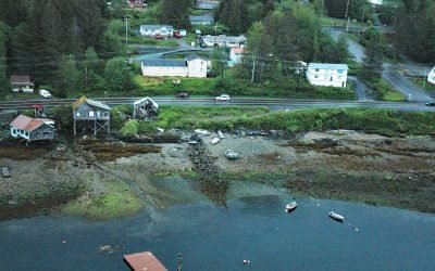
Saxman, Revillagigedo Island
Saxman is a community on the west coast of Revillagigedo Island on Tongass Narrows across from Pennock Island, about 86 miles (138 km) northwest of Prince Rupert and 3 miles (5 km) southwest of Ketchikan, Alaska.

Squaw Harbor, Unga Island
Squaw Harbor is a historical cannery and fishing village situated on the north shore of Baralof Bay on the east coast of Unga Island in the Shumagin Islands, about 258 miles (415 km) east-northeast of Unalaska and 7 miles (11 km) south-southwest of Sand Point, Alaska.

Lawson Harbour, Lewis Island
Lawson Harbour was a historical community on Lewis Island between Chismore Passage to the west and Arthur Passage to the east near the mouth of the Skeena River, about 75 miles (121 km) southwest of Terrace and 20 miles (32 km) south of Prince Rupert, British Columbia.

Stebbins, Saint Michael Island
Stebbins is a community in southern Norton Sound situated on a small sand spit along the northern shore of Saint Michael Island at Cape Stephens, which is in the lee of Stuart Island to the northwest and separated by a channel 1 mile (1.6 km) wide named Stephens Pass, about 117 miles (188 km) southeast of Nome and 52 miles (84 km) southwest of Unalakleet, Alaska.
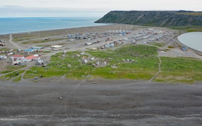
Gambell, Saint Lawrence Island
Gambell is a community on Saint Lawrence Island at Northwest Cape in the northern Bering Sea on a broad, shallow-water continental shelf that extends from western Alaska to northeastern Russia, about 196 miles (316 km) southwest of Nome, Alaska, and 62 miles (100 km) southeast of Provideniya, Russia.

Karluk Village, Kodiak Island
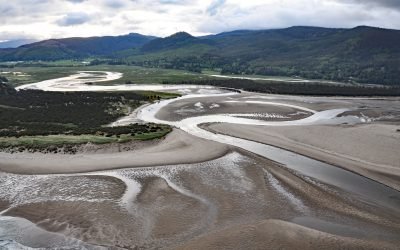
Karluk Village is situated on the southern shore of Karluk Lagoon, an embayment formed by a barrier spit that partially encloses the mouth of the Karluk River, on the Shelikof Strait coast of Kodiak Island, about 77 miles (124 km) west-southwest of Kodiak and 44 miles (71 km) north-northwest of Akhiok, Alaska.

Tununak, Nelson Island
Tununak is a traditional Central Yup’ik community located on the northwest coast of Nelson Island on a narrow barrier spit between the Bering Sea and the mouth of the Tununak River, about 119 miles (192 km) west-southwest of Bethel and 71 miles (114 km) south-southeast of Hooper Bay, Alaska.
Whalen Island, Sand Lake
Whalen Island is located in Sand Lake which is the estuary of Sand Creek that starts at an elevation of 770 feet (235 m) in the Oregon Coast Range and flows generally south-southwest for 8 miles (13 km) to the Pacific Ocean draining a watershed of 10,880 acres (4,403 ha), about 13 miles (21 km) south-southwest of Tillamook and 5 miles (8 km) north of Pacific City, Oregon.
About the background graphic
This ‘warming stripe’ graphic is a visual representation of the change in global temperature from 1850 (top) to 2019 (bottom). Each stripe represents the average global temperature for one year. The average temperature from 1971-2000 is set as the boundary between blue and red. The colour scale goes from -0.7°C to +0.7°C. The data are from the UK Met Office HadCRUT4.6 dataset.
Click here for more information about the #warmingstripes.