Communities
Recent Articles
More Articles
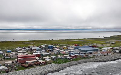
Shishmaref, Sarichef Island
Shishmaref is an Iñupiat community situated on Sarichef Island, a barrier island between Shishmaref Inlet to the south and the Chukchi Sea to the north, on the northern coast of the Seward Peninsula in the Bering Land Bridge National Preserve, about 105 miles (169 km) southwest of Kotzebue and 73 miles (117 km) northeast of Wales, Alaska.
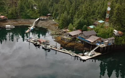
Port Protection, Wooden Wheel Cove
Port Protection is a community situated on Wooden Wheel Cove, at the northern tip of Prince of Wales Island in Tongass National Forest, about 140 miles (225 km) south-southwest of Juneau and 48 miles (77 km) west-northwest of Wrangell, Alaska.
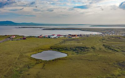
Saint Michael, Norton Sound
Saint Michael is a community situated on the eastern coast of Saint Michael Island, on Saint Michael Bay which is on the southern coast of Norton Sound, about 47 miles (76 km) southwest of Unalakleet and 8 miles (13 km) east-southeast of Stebbins, Alaska.
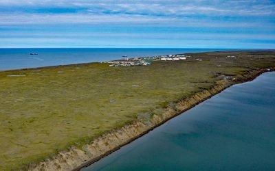
Wainwright, Kuk River
Wainwright is an Iñupiat community on the Chukchi Sea coastline situated on a barrier beach adjacent to Wainwright Inlet and the Kuk River, about 94 miles (151 km) northeast of Point Lay and 86 miles (138 km) southwest of Utqiaġvik, Alaska.
Graveyard Point, Skeena River
Graveyard Point is a historical steamboat landing and telegraph station near the confluence of the Shames River and the Skeena River, about 58 miles (94 km) east of Prince Rupert and 14 miles (23 km) southwest of Terrace, British Columbia.

Nikolski, Umnak Island
Nikolski is a community located near the southwest end of Umnak Island, one of the Fox Islands in the eastern Aleutian Islands, about 910 miles (1,468 km) southwest of Anchorage and 116 miles (187 km) southwest of Dutch Harbor, Alaska.

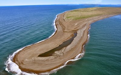
Klamath River, Requa
Klamath River flows for 257 miles (415 km) from a broad patchwork of lakes and marshes at the edge of the Oregon high desert, through the Cascade Range and the Klamath Mountains, and enters the Pacific Ocean at the community of Requa, about 52 miles (84 km) north of Eureka and 16 miles (26 km) south-southeast of Crescent City, California.
Tigara Peninsula, Chukchi Sea
Tigara Peninsula is a prominent point of land extending west for 13 miles (21 km) from the mouth of the Kukpuk River on the Cape Lisburne peninsula into the Chukchi Sea, about 320 miles (516 km) southwest of Utqiaġvik and 151 miles (244 km) northwest of Kotzebue, Alaska.
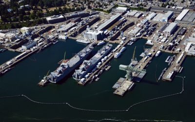
Puget Sound Naval Shipyard, Sinclair Inlet
Puget Sound Naval Shipyard is a U.S Navy facility on 179 acres (72.4 ha) on the north shore of Sinclair Inlet at Bremerton, about 23 miles (37 km) northwest of Tacoma and 15 miles (24 km) west of Seattle, Washington.
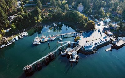
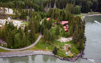
Fulford Harbour, Salt Spring Island
Fulford Harbour is an embayment and a small community on the southeast coast of Salt Spring Island, about 39 miles (63 km) southwest of Vancouver and 9 miles (14.5 km) north-northwest of Sidney, British Columbia.
About the background graphic
This ‘warming stripe’ graphic is a visual representation of the change in global temperature from 1850 (top) to 2019 (bottom). Each stripe represents the average global temperature for one year. The average temperature from 1971-2000 is set as the boundary between blue and red. The colour scale goes from -0.7°C to +0.7°C. The data are from the UK Met Office HadCRUT4.6 dataset.
Click here for more information about the #warmingstripes.