Historical Sites
Recent Articles
More Articles
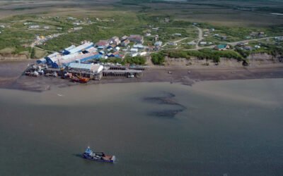
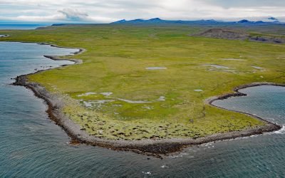
Diamond NN Cannery, South Naknek
Diamond NN is a historic cannery in South Naknek at the mouth of the Naknek River that flows into Kvichak Bay, an arm of Bristol Bay, about 56 miles (90 km) southeast of Dillingham and 13 miles (21 km) west of King Salmon, Alaska.
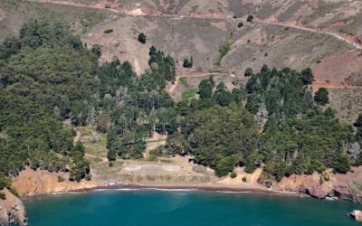
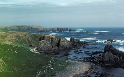
Kirby Cove, Marin Headlands
Kirby Cove is an embayment in the Marin Headlands on the northern shore of the Golden Gate in the Golden Gate National Recreation Area, and the site of a historic military installation, about 5.5 miles (9 km) northwest of downtown San Francisco and 2.3 miles (4 km) south of Sausalito, California.
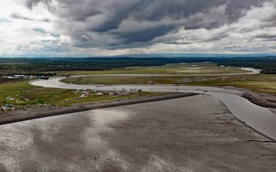
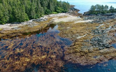
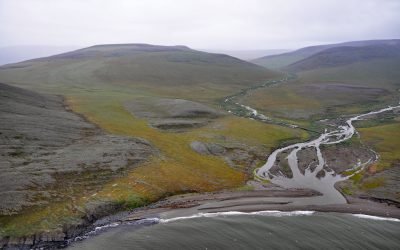
Kasilof River, Kenai Peninsula
Kasilof River starts at the outlet of Tustumena Lake on the Kenai Peninsula and flows generally northwest for 17 miles (27 km) through the Kenai Lowland to Cook Inlet, draining a watershed of 93,275 acres (37,747 ha), about 51 miles (82 km) north-northeast of Homer and 13 miles (21 km) south-southwest of Kenai, Alaska.
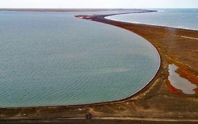
Leffingwell Camp, Flaxman Island
Leffingwell Camp is situated on Flaxman Island, a shape-shifting barrier island separating the Beaufort Sea to the north and Lion Bay to the south, about 58 miles (94 km) east of Deadhorse and 58 miles (94 km) west of Kaktovik, Alaska.
Makarius Bay, Amchitka Island
Makarius Bay is on the southeastern coast of Amchitka Island, the southernmost of the Rat Islands group in the Aleutian Islands of Southwest Alaska, bounded by the Bering Sea to the north and the Pacific Ocean to the south, about 2500 miles (4024 km) north-northwest of Honolulu and 182 miles (293 km) west-southwest of Adak, Alaska.
Kaigani Point, Long Island
Kaigani Point is at the southwest tip of Long Island between Kaigani Strait to the west and Cordova Bay to the east, about 100 miles (161 km) northwest of Prince Rupert and 56 miles (90 km) southwest of Ketchikan, Alaska.
Point Barrow, Elson Lagoon
Point Barrow is a spit that extends northeast from the mainland for 4 miles (6.4 km) into the Arctic Ocean forming Elson Lagoon to the southeast, about 150 miles (242 km) northwest of Nuiqsut and 9.8 miles (16 km) northeast of Utqiaġvik, Alaska.
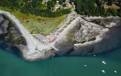
Little Boston, Point Julia
Little Boston is a community at the base of Point Julia on the east side entrance of Port Gamble, an inlet on the Kitsap Peninsula near the entrance to Hood Canal, about 21 miles (34 km) northwest of Seattle and 20 miles (32 km) southeast of Port Townsend, Washington.
Cape Kookoolik, Saint Lawrence Island
Kookoolik is a historical community, also known as Kukulik, located on Cape Kookoolik on the northern coast of Saint Lawrence Island, about 160 miles (258 km) southwest of Nome and 4 miles (6.5 km) east of Savoonga, Alaska.
Kapaloak Creek, Cape Dyer
Kapaloak Creek starts from an elevation of roughly 1200 feet (366 m) in the Lisburne Hills and flows generally west for 8.5 miles (14 km) to Cape Dyer on the Chukchi Sea and the site of a historical Iñupiat village, about 110 miles (177 km) southwest of Point Lay and 25 miles (40 km) north-northeast of Point Hope, Alaska.
About the background graphic
This ‘warming stripe’ graphic is a visual representation of the change in global temperature from 1850 (top) to 2019 (bottom). Each stripe represents the average global temperature for one year. The average temperature from 1971-2000 is set as the boundary between blue and red. The colour scale goes from -0.7°C to +0.7°C. The data are from the UK Met Office HadCRUT4.6 dataset.
Click here for more information about the #warmingstripes.